GAF AG |
|
GAF AG WMS SERVER


| Service health Now: |
|---|
- Interface
- Web Service, OGC Web Map Service 1.3.0
- Keywords
- GAF AG, EUFODOS, ENVIRONMENT, GEOSCIENTIFIC INFORMATION
- Fees
- FREE FOR PRIVATE USE ONLY!
- Access constraints
- Some restrictions may apply
- Supported languages
- No INSPIRE Extended Capabilities (including service language support) given. See INSPIRE Technical Guidance - View Services for more information.
- Data provider
-
GAF AG (unverified)
Contact information:
Webmaster
GAF AG
Arnulfstr. 199, 80634 Munich, Germany
Email:
- Service metadata
- No INSPIRE Extended Capabilities (including service metadata) given. See INSPIRE Technical Guidance - View Services for more information.
Ads by Google
This WMS belongs to GAF AG, Munich. It provides public layers and restricted layers that may only be accessible by authorized users. Layers in the public namespace are free for private use only!
Available map layers (30)
Titel (public:ingeosat_base)
Abstract
public:world_basemap (public:world_basemap)
Layer-Group type layer: public:world_basemap
10m-lakes (public:10m-lakes)
10m-urban-area (public:10m-urban-area)
10m_bathymetry_F_5000 (public:10m_bathymetry_F_5000)
10m_bathymetry_G_4000 (public:10m_bathymetry_G_4000)
10m_bathymetry_H_3000 (public:10m_bathymetry_H_3000)
10m_bathymetry_I_2000 (public:10m_bathymetry_I_2000)
10m_bathymetry_J_1000 (public:10m_bathymetry_J_1000)
10m_bathymetry_K_200 (public:10m_bathymetry_K_200)
10m_ocean (public:10m_ocean)
10m_populated_places (public:10m_populated_places)
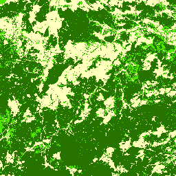
Forest Type Map (eufodos:CORE-Forest-Types_v1_6_w_3classes)
A High Resolution Forest Type Map for the reference year 2009 has been produced based on Image 2009 (IRS LISS-III, Spot 4 and 5). Herein continuous broadleave fraction values (0% to 100%) have been mapped on a pixel basis. The values below 51% have been aggregated to the class Coniferous Forest whereas the values above have been aggregated to Broadleave Forest. According to the product definition, all pixels below 10% Tree Cover Density have been excluded and a Minimum Mapping Unit has been applied for the final map product. The product provides a geometric accuracy of 20m RMS determined for the ortho-rectified images. The verification of the classes has been done using available LUCAS data.
Tree Cover Density (eufodos:CORE-Tree-Cover-Density_1_3)
A High Resolution Tree Cover Density layer for the reference year 2009 has been produced based on Image 2009 (IRS LISS-III, Spot 4 and 5). Herein continuous tree cover density values (0% to 100%) on a pixel basis have been mapped. The product provides a geometric accuracy of 20m RMS determined for the ortho-rectified images. The verification of the continuous values is not foreseen in the framework conditions of the GIO Land project.
DE_1K.shp (sec_ingeosat:DE_1K.shp)
Reference Grid 1km Germany
Spruce Map (eufodos:DS-Spruce-Map_1_3)
The Map of Spruce Stands for the reference year 2009 has been produced based on Image 2009 (IRS LISS-III, Spot 4 and 5) and the HR Forest Core Layer on Forest Types. The thematic classes are Non-Forest, Spruce stands and other forest stands) mapped ona pixel basis. The product provides a geometric accuracy of 20m RMS determined for the ortho-rectified images. The verification of the Map on Spruce stands will be done by the user Thüringen Forst in the begin of EUFODOS phase 2.
Tree Cover Change Leutenberg (eufodos:DS-Tree-Cover-Change_Neuhaus-Gehren-Leutenberg_1_0)
The Change Map on Forest Operations and Damages between the reference years 2009 and 2011 has been produced based on Image 2009 (IRS LISS-III, Spot 4 and 5), the HR Forest Core Layers and RapidEye data from 2010/2011. The product only includes the class ”Potential Change” mapped on a segment basis. The product provides a geometric accuracy of 5m RMS determined for the ortho-rectified images. The verification of the Change Map on Forest Operations and Damages will be done by the user Thüringen Forst in the begin of EUFODOS phase 2. Internal documentation on forest processes are allowing them to compare the classified changes directly with the forest operations mainly based on thinning, felling and damages caused by snow and insects.
Tree Cover Change Stadtroda (eufodos:DS-Tree-Cover-Change_Stadtroda_1_0)
The Change Map on Forest Operations and Damages between the reference years 2009 and 2011 has been produced based on Image 2009 (IRS LISS-III, Spot 4 and 5), the HR Forest Core Layers and RapidEye data from 2010/2011. The product only includes the class ”Potential Change” mapped on a segment basis. The product provides a geometric accuracy of 5m RMS determined for the ortho-rectified images. The verification of the Change Map on Forest Operations and Damages will be done by the user Thüringen Forst in the begin of EUFODOS phase 2. Internal documentation on forest processes are allowing them to compare the classified changes directly with the forest operations mainly based on thinning, felling and damages caused by snow and insects.
Tree Cover Map (eufodos:DS-Tree-Cover-Map_1_2)
The Tree Cover Map is not an official GIO HR Forest Core Layer but can be derived from the Tree Cover Density. The Tree Cover Map is a thematic layer which represents the classes Tree or No Tree on a pixel basis (no MMU). No forest definition is applied. With reference to the Tree Cover Density product, the map has been produced based on IMAGE 2009. The product provides a geometric accuracy of 20m RMS determined for the ortho-rectified images. The verification of the classes has been done using available LUCAS data.
NUTSV9_LEAC.shp (sec_ingeosat:NUTSV9_LEAC.shp)
NUTS Level
dem_world_dd_mosaic_hs_8bit_lut (public:dem_world_dd_mosaic_hs_8bit_lut)
Euromaps Landcover Bayern (public:emlc_bayern)
Euro-Maps Land Cover ist ein neues Produkt der Euro-Maps Produktfamilie. Es liefert flächendeckende, präzise und hochaktuelle Landnutzungs- und Bedeckungsdaten der Bundesrepublik Deutschland. Die herausragende Qualität resultiert aus kontinuierlich optimierten Arbeitsabläufen und der Erfahrung aus 2 Mio. km² ausgewerteter Fläche im Maßstab 1:50.000 und 1:25.000. Die thematische Genauigkeit wird durch visuelle Kontrollen für jedes einzelne Objekt und durch die Verwendung von Zusatzinformationen aus Euro-Maps 2D, Stadtplänen oder topographischen Karten bei der Interpretation garantiert.
Euromaps Landcover Muenchen (public:emlc_muc)
Euro-Maps Land Cover ist ein neues Produkt der Euro-Maps Produktfamilie. Es liefert flächendeckende, präzise und hochaktuelle Landnutzungs- und Bedeckungsdaten der Bundesrepublik Deutschland. Die herausragende Qualität resultiert aus kontinuierlich optimierten Arbeitsabläufen und der Erfahrung aus 2 Mio. km² ausgewerteter Fläche im Maßstab 1:50.000 und 1:25.000. Die thematische Genauigkeit wird durch visuelle Kontrollen für jedes einzelne Objekt und durch die Verwendung von Zusatzinformationen aus Euro-Maps 2D, Stadtplänen oder topographischen Karten bei der Interpretation garantiert.
forest_area_ETRS89.shp (sec_ingeosat:forest_area_ETRS89.shp)
forest complete ETRS89 GC2 (sec_ingeosat:forest_complete_ETRS89)
ing_bg_basiskarte_2006_geotif (sec_prjingeosat:ing_bg_basiskarte_2006_geotif)
ing_bg_windwurf_2007 (sec_prjingeosat:ing_bg_windwurf_2007)
irs_p6_liss-iii_20060613_vor_kyrill (sec_prjingeosat:irs_p6_liss-iii_20060613_vor_kyrill)
irs_p6_liss-iii_20070421_nach_kyrill (sec_prjingeosat:irs_p6_liss-iii_20070421_nach_kyrill)
ne_10m_rivers_lake_centerlines_scale_ranks (public:ne_10m_rivers_lake_centerlines_scale_ranks)
There are currently no notifications for the service, click the feed icon to subscribe.