Polish Geological Institute - National… |
|
Geological map of Poland in 1:1 000 000 scale

| Service health Now: |
|---|
- Interface
- Web Service, OGC Web Map Service 1.3.0
- Keywords
- geology, harmonized geology, infoMapAccessService, ONEGEOLOGY, stratigraphy, lithology
- Fees
- unknown
- Access constraints
- unknown
- Supported languages
- No INSPIRE Extended Capabilities (including service language support) given. See INSPIRE Technical Guidance - View Services for more information.
- Data provider
-
Polish Geological Institute - National Research Institute (unverified)
Contact information:
Urszula Stepien
Polish Geological Institute - National Research Institute
postal:
Rakowiecka 4, 00-975 Warsaw, PolskaEmail:
Phone: +48224592000
- Service metadata
- No INSPIRE Extended Capabilities (including service metadata) given. See INSPIRE Technical Guidance - View Services for more information.
Ads by Google
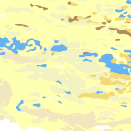
The map depicts the superficial geology of Poland at 1:1000 000 scale, using the Coordinate System WGS84. It includes the following thematic layers: Geological units, Tectonics, Limits of Glaciation and basic topographic layers (administrative boundaries, drainage, settlements). The map was compiled as a contribution to the OneGeology Europe Project. The map was created under the direction of the Ministry of the Environment and funded by the National Fund for Environmental Protection and Water Management.
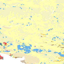
Available map layers (8)
Geological map of Poland in 1:1 000 000 scale (onegeology)
The map depicts the superficial geology of Poland at 1:1000 000 scale, using the Coordinate System WGS84. It includes the following thematic layers: Geological units, Tectonics, Limits of Glaciation and basic topographic layers (administrative boundaries, drainage, settlements). The map was compiled as a contribution to the OneGeology Europe Project. The map was created under the direction of the Ministry of the Environment and funded by the National Fund for Environmental Protection and Water Management.
POL PGI 1:1M Geological units (POL_PGI_1M_GeoUnits)
POL PGI 1:1M Lakes (POL_PGI_1M_Lakes)
POL PGI 1:1M Glaciation limits (POL_PGI_1M_Glacial)
POL PGI 1:1M Geological boundaries, National boundaries (POL_PGI_1M_ContType)
POL PGI 1:1M Faults, Overthrust (POL_PGI_1M_Faults)
POL PGI 1:1M Rivers, Waters boundaries (POL_PGI_1M_Rivers)
POL PGI 1:1M Boundary (POL_PGI_1M_Boundary)
There are currently no notifications for the service, click the feed icon to subscribe.