MINES ParisTech |
|
Webservice-Energy (WMS)
http://geoserver.webservice-energy.org/geoserver/energeo/ows
| Service health Now: |
|---|
- Interface
- Web Service, OGC Web Map Service 1.3.0
- Keywords
- WFS, WMS, GEOSERVER
- Fees
- NONE
- Access constraints
- NONE
- Supported languages
- No INSPIRE Extended Capabilities (including service language support) given. See INSPIRE Technical Guidance - View Services for more information.
- Data provider
-
MINES ParisTech (unverified)
Contact information:
Lionel MENARD
MINES ParisTech
Work:
1, rue Claude Daunesse - CS 10207, 06904 SOPHIA ANTIPOLIS, FRANCEEmail:
- Service metadata
- No INSPIRE Extended Capabilities (including service metadata) given. See INSPIRE Technical Guidance - View Services for more information.
Ads by Google
A compliant implementation of WMS plus most of the SLD extension (dynamic styling). Can also generate PDF, SVG, KML, GeoRSS
Available map layers (147)
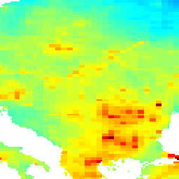
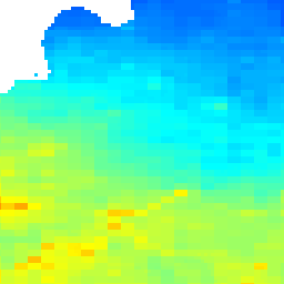
LLE_vs_TNO_2008_layer_08 (LLE_vs_TNO_2008_layer_08)
Total_PM_2.5_from_TNO_2008 (Total_PM_2.5_from_TNO_2008)
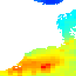
Lost of life expectancy for cohorts 30 to 95 years old. Total PM 2.5 from TNO 2008
cc_15_30_hOM_bfond_hFR_Lo (cc_15_30_hOM_bfond_hFR_Lo)
Legend for understanding map title names and their related configuration eg: cc_15_50_lOM_bfond_hFR_Lo_geo Each parameter is separated with an underscore (_) (1) Impact category: cc= climate change, res= resources, daly= daly, eco= ecosystem (2) Life time: 15 years vs 20 years vs 25 years (3) Number of wind turbines per farm: 30 vs 40 vs 50 (max.capacity : 50 wind turbines per farm) (4) Maintenance scenario: low Operating Maintenance (lOM) or high Operating Maintenance (hOM) (5) Foundation type: only fixed (xfond) vs floating & fixed (both: bfond) (6) Failure rate: low Failure Rate (lFR) or high Failure Rate (hFR) (7) Electricity loss: 4 % electricity loss included (Lo) vs non-included electricity loss (NoLo) (8) geo: GeoTIFF file
cc_15_30_hOM_bfond_lFR_Lo (cc_15_30_hOM_bfond_lFR_Lo)
Legend for understanding map title names and their related configuration eg: cc_15_50_lOM_bfond_hFR_Lo_geo Each parameter is separated with an underscore (_) (1) Impact category: cc= climate change, res= resources, daly= daly, eco= ecosystem (2) Life time: 15 years vs 20 years vs 25 years (3) Number of wind turbines per farm: 30 vs 40 vs 50 (max.capacity : 50 wind turbines per farm) (4) Maintenance scenario: low Operating Maintenance (lOM) or high Operating Maintenance (hOM) (5) Foundation type: only fixed (xfond) vs floating & fixed (both: bfond) (6) Failure rate: low Failure Rate (lFR) or high Failure Rate (hFR) (7) Electricity loss: 4 % electricity loss included (Lo) vs non-included electricity loss (NoLo) (8) geo: GeoTIFF file
cc_15_30_lOM_bfond_hFR_Lo (cc_15_30_lOM_bfond_hFR_Lo)
Legend for understanding map title names and their related configuration eg: cc_15_50_lOM_bfond_hFR_Lo_geo Each parameter is separated with an underscore (_) (1) Impact category: cc= climate change, res= resources, daly= daly, eco= ecosystem (2) Life time: 15 years vs 20 years vs 25 years (3) Number of wind turbines per farm: 30 vs 40 vs 50 (max.capacity : 50 wind turbines per farm) (4) Maintenance scenario: low Operating Maintenance (lOM) or high Operating Maintenance (hOM) (5) Foundation type: only fixed (xfond) vs floating & fixed (both: bfond) (6) Failure rate: low Failure Rate (lFR) or high Failure Rate (hFR) (7) Electricity loss: 4 % electricity loss included (Lo) vs non-included electricity loss (NoLo) (8) geo: GeoTIFF file
cc_15_30_lOM_bfond_lFR_Lo (cc_15_30_lOM_bfond_lFR_Lo)
Legend for understanding map title names and their related configuration eg: cc_15_50_lOM_bfond_hFR_Lo_geo Each parameter is separated with an underscore (_) (1) Impact category: cc= climate change, res= resources, daly= daly, eco= ecosystem (2) Life time: 15 years vs 20 years vs 25 years (3) Number of wind turbines per farm: 30 vs 40 vs 50 (max.capacity : 50 wind turbines per farm) (4) Maintenance scenario: low Operating Maintenance (lOM) or high Operating Maintenance (hOM) (5) Foundation type: only fixed (xfond) vs floating & fixed (both: bfond) (6) Failure rate: low Failure Rate (lFR) or high Failure Rate (hFR) (7) Electricity loss: 4 % electricity loss included (Lo) vs non-included electricity loss (NoLo) (8) geo: GeoTIFF file
cc_15_40_hOM_bfond_hFR_Lo (cc_15_40_hOM_bfond_hFR_Lo)
Legend for understanding map title names and their related configuration eg: cc_15_50_lOM_bfond_hFR_Lo_geo Each parameter is separated with an underscore (_) (1) Impact category: cc= climate change, res= resources, daly= daly, eco= ecosystem (2) Life time: 15 years vs 20 years vs 25 years (3) Number of wind turbines per farm: 30 vs 40 vs 50 (max.capacity : 50 wind turbines per farm) (4) Maintenance scenario: low Operating Maintenance (lOM) or high Operating Maintenance (hOM) (5) Foundation type: only fixed (xfond) vs floating & fixed (both: bfond) (6) Failure rate: low Failure Rate (lFR) or high Failure Rate (hFR) (7) Electricity loss: 4 % electricity loss included (Lo) vs non-included electricity loss (NoLo) (8) geo: GeoTIFF file
cc_15_40_hOM_bfond_lFR_Lo (cc_15_40_hOM_bfond_lFR_Lo)
Legend for understanding map title names and their related configuration eg: cc_15_50_lOM_bfond_hFR_Lo_geo Each parameter is separated with an underscore (_) (1) Impact category: cc= climate change, res= resources, daly= daly, eco= ecosystem (2) Life time: 15 years vs 20 years vs 25 years (3) Number of wind turbines per farm: 30 vs 40 vs 50 (max.capacity : 50 wind turbines per farm) (4) Maintenance scenario: low Operating Maintenance (lOM) or high Operating Maintenance (hOM) (5) Foundation type: only fixed (xfond) vs floating & fixed (both: bfond) (6) Failure rate: low Failure Rate (lFR) or high Failure Rate (hFR) (7) Electricity loss: 4 % electricity loss included (Lo) vs non-included electricity loss (NoLo) (8) geo: GeoTIFF file
cc_15_40_lOM_bfond_hFR_Lo (cc_15_40_lOM_bfond_hFR_Lo)
Legend for understanding map title names and their related configuration eg: cc_15_50_lOM_bfond_hFR_Lo_geo Each parameter is separated with an underscore (_) (1) Impact category: cc= climate change, res= resources, daly= daly, eco= ecosystem (2) Life time: 15 years vs 20 years vs 25 years (3) Number of wind turbines per farm: 30 vs 40 vs 50 (max.capacity : 50 wind turbines per farm) (4) Maintenance scenario: low Operating Maintenance (lOM) or high Operating Maintenance (hOM) (5) Foundation type: only fixed (xfond) vs floating & fixed (both: bfond) (6) Failure rate: low Failure Rate (lFR) or high Failure Rate (hFR) (7) Electricity loss: 4 % electricity loss included (Lo) vs non-included electricity loss (NoLo) (8) geo: GeoTIFF file
cc_15_40_lOM_bfond_lFR_Lo (cc_15_40_lOM_bfond_lFR_Lo)
Legend for understanding map title names and their related configuration eg: cc_15_50_lOM_bfond_hFR_Lo_geo Each parameter is separated with an underscore (_) (1) Impact category: cc= climate change, res= resources, daly= daly, eco= ecosystem (2) Life time: 15 years vs 20 years vs 25 years (3) Number of wind turbines per farm: 30 vs 40 vs 50 (max.capacity : 50 wind turbines per farm) (4) Maintenance scenario: low Operating Maintenance (lOM) or high Operating Maintenance (hOM) (5) Foundation type: only fixed (xfond) vs floating & fixed (both: bfond) (6) Failure rate: low Failure Rate (lFR) or high Failure Rate (hFR) (7) Electricity loss: 4 % electricity loss included (Lo) vs non-included electricity loss (NoLo) (8) geo: GeoTIFF file
cc_15_50_hOM_bfond_hFR_Lo (cc_15_50_hOM_bfond_hFR_Lo)
Legend for understanding map title names and their related configuration eg: cc_15_50_lOM_bfond_hFR_Lo_geo Each parameter is separated with an underscore (_) (1) Impact category: cc= climate change, res= resources, daly= daly, eco= ecosystem (2) Life time: 15 years vs 20 years vs 25 years (3) Number of wind turbines per farm: 30 vs 40 vs 50 (max.capacity : 50 wind turbines per farm) (4) Maintenance scenario: low Operating Maintenance (lOM) or high Operating Maintenance (hOM) (5) Foundation type: only fixed (xfond) vs floating & fixed (both: bfond) (6) Failure rate: low Failure Rate (lFR) or high Failure Rate (hFR) (7) Electricity loss: 4 % electricity loss included (Lo) vs non-included electricity loss (NoLo) (8) geo: GeoTIFF file
cc_15_50_hOM_bfond_lFR_Lo (cc_15_50_hOM_bfond_lFR_Lo)
Legend for understanding map title names and their related configuration eg: cc_15_50_lOM_bfond_hFR_Lo_geo Each parameter is separated with an underscore (_) (1) Impact category: cc= climate change, res= resources, daly= daly, eco= ecosystem (2) Life time: 15 years vs 20 years vs 25 years (3) Number of wind turbines per farm: 30 vs 40 vs 50 (max.capacity : 50 wind turbines per farm) (4) Maintenance scenario: low Operating Maintenance (lOM) or high Operating Maintenance (hOM) (5) Foundation type: only fixed (xfond) vs floating & fixed (both: bfond) (6) Failure rate: low Failure Rate (lFR) or high Failure Rate (hFR) (7) Electricity loss: 4 % electricity loss included (Lo) vs non-included electricity loss (NoLo) (8) geo: GeoTIFF file
cc_15_50_lOM_bfond_hFR_Lo (cc_15_50_lOM_bfond_hFR_Lo)
Legend for understanding map title names and their related configuration eg: cc_15_50_lOM_bfond_hFR_Lo_geo Each parameter is separated with an underscore (_) (1) Impact category: cc= climate change, res= resources, daly= daly, eco= ecosystem (2) Life time: 15 years vs 20 years vs 25 years (3) Number of wind turbines per farm: 30 vs 40 vs 50 (max.capacity : 50 wind turbines per farm) (4) Maintenance scenario: low Operating Maintenance (lOM) or high Operating Maintenance (hOM) (5) Foundation type: only fixed (xfond) vs floating & fixed (both: bfond) (6) Failure rate: low Failure Rate (lFR) or high Failure Rate (hFR) (7) Electricity loss: 4 % electricity loss included (Lo) vs non-included electricity loss (NoLo) (8) geo: GeoTIFF file
cc_15_50_lOM_bfond_lFR_Lo (cc_15_50_lOM_bfond_lFR_Lo)
Legend for understanding map title names and their related configuration eg: cc_15_50_lOM_bfond_hFR_Lo_geo Each parameter is separated with an underscore (_) (1) Impact category: cc= climate change, res= resources, daly= daly, eco= ecosystem (2) Life time: 15 years vs 20 years vs 25 years (3) Number of wind turbines per farm: 30 vs 40 vs 50 (max.capacity : 50 wind turbines per farm) (4) Maintenance scenario: low Operating Maintenance (lOM) or high Operating Maintenance (hOM) (5) Foundation type: only fixed (xfond) vs floating & fixed (both: bfond) (6) Failure rate: low Failure Rate (lFR) or high Failure Rate (hFR) (7) Electricity loss: 4 % electricity loss included (Lo) vs non-included electricity loss (NoLo) (8) geo: GeoTIFF file
cc_20_30_hOM_bfond_hFR_Lo (cc_20_30_hOM_bfond_hFR_Lo)
Legend for understanding map title names and their related configuration eg: cc_15_50_lOM_bfond_hFR_Lo_geo Each parameter is separated with an underscore (_) (1) Impact category: cc= climate change, res= resources, daly= daly, eco= ecosystem (2) Life time: 15 years vs 20 years vs 25 years (3) Number of wind turbines per farm: 30 vs 40 vs 50 (max.capacity : 50 wind turbines per farm) (4) Maintenance scenario: low Operating Maintenance (lOM) or high Operating Maintenance (hOM) (5) Foundation type: only fixed (xfond) vs floating & fixed (both: bfond) (6) Failure rate: low Failure Rate (lFR) or high Failure Rate (hFR) (7) Electricity loss: 4 % electricity loss included (Lo) vs non-included electricity loss (NoLo) (8) geo: GeoTIFF file
cc_20_30_hOM_bfond_lFR_Lo (cc_20_30_hOM_bfond_lFR_Lo)
Legend for understanding map title names and their related configuration eg: cc_15_50_lOM_bfond_hFR_Lo_geo Each parameter is separated with an underscore (_) (1) Impact category: cc= climate change, res= resources, daly= daly, eco= ecosystem (2) Life time: 15 years vs 20 years vs 25 years (3) Number of wind turbines per farm: 30 vs 40 vs 50 (max.capacity : 50 wind turbines per farm) (4) Maintenance scenario: low Operating Maintenance (lOM) or high Operating Maintenance (hOM) (5) Foundation type: only fixed (xfond) vs floating & fixed (both: bfond) (6) Failure rate: low Failure Rate (lFR) or high Failure Rate (hFR) (7) Electricity loss: 4 % electricity loss included (Lo) vs non-included electricity loss (NoLo) (8) geo: GeoTIFF file
cc_20_30_lOM_bfond_hFR_Lo (cc_20_30_lOM_bfond_hFR_Lo)
Legend for understanding map title names and their related configuration eg: cc_15_50_lOM_bfond_hFR_Lo_geo Each parameter is separated with an underscore (_) (1) Impact category: cc= climate change, res= resources, daly= daly, eco= ecosystem (2) Life time: 15 years vs 20 years vs 25 years (3) Number of wind turbines per farm: 30 vs 40 vs 50 (max.capacity : 50 wind turbines per farm) (4) Maintenance scenario: low Operating Maintenance (lOM) or high Operating Maintenance (hOM) (5) Foundation type: only fixed (xfond) vs floating & fixed (both: bfond) (6) Failure rate: low Failure Rate (lFR) or high Failure Rate (hFR) (7) Electricity loss: 4 % electricity loss included (Lo) vs non-included electricity loss (NoLo) (8) geo: GeoTIFF file
cc_20_30_lOM_bfond_lFR_Lo (cc_20_30_lOM_bfond_lFR_Lo)
Legend for understanding map title names and their related configuration eg: cc_15_50_lOM_bfond_hFR_Lo_geo Each parameter is separated with an underscore (_) (1) Impact category: cc= climate change, res= resources, daly= daly, eco= ecosystem (2) Life time: 15 years vs 20 years vs 25 years (3) Number of wind turbines per farm: 30 vs 40 vs 50 (max.capacity : 50 wind turbines per farm) (4) Maintenance scenario: low Operating Maintenance (lOM) or high Operating Maintenance (hOM) (5) Foundation type: only fixed (xfond) vs floating & fixed (both: bfond) (6) Failure rate: low Failure Rate (lFR) or high Failure Rate (hFR) (7) Electricity loss: 4 % electricity loss included (Lo) vs non-included electricity loss (NoLo) (8) geo: GeoTIFF file
cc_20_40_hOM_bfond_hFR_Lo (cc_20_40_hOM_bfond_hFR_Lo)
Legend for understanding map title names and their related configuration eg: cc_15_50_lOM_bfond_hFR_Lo_geo Each parameter is separated with an underscore (_) (1) Impact category: cc= climate change, res= resources, daly= daly, eco= ecosystem (2) Life time: 15 years vs 20 years vs 25 years (3) Number of wind turbines per farm: 30 vs 40 vs 50 (max.capacity : 50 wind turbines per farm) (4) Maintenance scenario: low Operating Maintenance (lOM) or high Operating Maintenance (hOM) (5) Foundation type: only fixed (xfond) vs floating & fixed (both: bfond) (6) Failure rate: low Failure Rate (lFR) or high Failure Rate (hFR) (7) Electricity loss: 4 % electricity loss included (Lo) vs non-included electricity loss (NoLo) (8) geo: GeoTIFF file
cc_20_40_hOM_bfond_lFR_Lo (cc_20_40_hOM_bfond_lFR_Lo)
Legend for understanding map title names and their related configuration eg: cc_15_50_lOM_bfond_hFR_Lo_geo Each parameter is separated with an underscore (_) (1) Impact category: cc= climate change, res= resources, daly= daly, eco= ecosystem (2) Life time: 15 years vs 20 years vs 25 years (3) Number of wind turbines per farm: 30 vs 40 vs 50 (max.capacity : 50 wind turbines per farm) (4) Maintenance scenario: low Operating Maintenance (lOM) or high Operating Maintenance (hOM) (5) Foundation type: only fixed (xfond) vs floating & fixed (both: bfond) (6) Failure rate: low Failure Rate (lFR) or high Failure Rate (hFR) (7) Electricity loss: 4 % electricity loss included (Lo) vs non-included electricity loss (NoLo) (8) geo: GeoTIFF file
cc_20_40_lOM_bfond_hFR_Lo (cc_20_40_lOM_bfond_hFR_Lo)
Legend for understanding map title names and their related configuration eg: cc_15_50_lOM_bfond_hFR_Lo_geo Each parameter is separated with an underscore (_) (1) Impact category: cc= climate change, res= resources, daly= daly, eco= ecosystem (2) Life time: 15 years vs 20 years vs 25 years (3) Number of wind turbines per farm: 30 vs 40 vs 50 (max.capacity : 50 wind turbines per farm) (4) Maintenance scenario: low Operating Maintenance (lOM) or high Operating Maintenance (hOM) (5) Foundation type: only fixed (xfond) vs floating & fixed (both: bfond) (6) Failure rate: low Failure Rate (lFR) or high Failure Rate (hFR) (7) Electricity loss: 4 % electricity loss included (Lo) vs non-included electricity loss (NoLo) (8) geo: GeoTIFF file
cc_20_40_lOM_bfond_lFR_Lo (cc_20_40_lOM_bfond_lFR_Lo)
Legend for understanding map title names and their related configuration eg: cc_15_50_lOM_bfond_hFR_Lo_geo Each parameter is separated with an underscore (_) (1) Impact category: cc= climate change, res= resources, daly= daly, eco= ecosystem (2) Life time: 15 years vs 20 years vs 25 years (3) Number of wind turbines per farm: 30 vs 40 vs 50 (max.capacity : 50 wind turbines per farm) (4) Maintenance scenario: low Operating Maintenance (lOM) or high Operating Maintenance (hOM) (5) Foundation type: only fixed (xfond) vs floating & fixed (both: bfond) (6) Failure rate: low Failure Rate (lFR) or high Failure Rate (hFR) (7) Electricity loss: 4 % electricity loss included (Lo) vs non-included electricity loss (NoLo) (8) geo: GeoTIFF file
cc_20_50_hOM_bfond_hFR_Lo (cc_20_50_hOM_bfond_hFR_Lo)
Legend for understanding map title names and their related configuration eg: cc_15_50_lOM_bfond_hFR_Lo_geo Each parameter is separated with an underscore (_) (1) Impact category: cc= climate change, res= resources, daly= daly, eco= ecosystem (2) Life time: 15 years vs 20 years vs 25 years (3) Number of wind turbines per farm: 30 vs 40 vs 50 (max.capacity : 50 wind turbines per farm) (4) Maintenance scenario: low Operating Maintenance (lOM) or high Operating Maintenance (hOM) (5) Foundation type: only fixed (xfond) vs floating & fixed (both: bfond) (6) Failure rate: low Failure Rate (lFR) or high Failure Rate (hFR) (7) Electricity loss: 4 % electricity loss included (Lo) vs non-included electricity loss (NoLo) (8) geo: GeoTIFF file
cc_20_50_hOM_bfond_lFR_Lo (cc_20_50_hOM_bfond_lFR_Lo)
Legend for understanding map title names and their related configuration eg: cc_15_50_lOM_bfond_hFR_Lo_geo Each parameter is separated with an underscore (_) (1) Impact category: cc= climate change, res= resources, daly= daly, eco= ecosystem (2) Life time: 15 years vs 20 years vs 25 years (3) Number of wind turbines per farm: 30 vs 40 vs 50 (max.capacity : 50 wind turbines per farm) (4) Maintenance scenario: low Operating Maintenance (lOM) or high Operating Maintenance (hOM) (5) Foundation type: only fixed (xfond) vs floating & fixed (both: bfond) (6) Failure rate: low Failure Rate (lFR) or high Failure Rate (hFR) (7) Electricity loss: 4 % electricity loss included (Lo) vs non-included electricity loss (NoLo) (8) geo: GeoTIFF file
cc_20_50_lOM_bfond_hFR_Lo (cc_20_50_lOM_bfond_hFR_Lo)
Legend for understanding map title names and their related configuration eg: cc_15_50_lOM_bfond_hFR_Lo_geo Each parameter is separated with an underscore (_) (1) Impact category: cc= climate change, res= resources, daly= daly, eco= ecosystem (2) Life time: 15 years vs 20 years vs 25 years (3) Number of wind turbines per farm: 30 vs 40 vs 50 (max.capacity : 50 wind turbines per farm) (4) Maintenance scenario: low Operating Maintenance (lOM) or high Operating Maintenance (hOM) (5) Foundation type: only fixed (xfond) vs floating & fixed (both: bfond) (6) Failure rate: low Failure Rate (lFR) or high Failure Rate (hFR) (7) Electricity loss: 4 % electricity loss included (Lo) vs non-included electricity loss (NoLo) (8) geo: GeoTIFF file
cc_20_50_lOM_bfond_lFR_Lo (cc_20_50_lOM_bfond_lFR_Lo)
Legend for understanding map title names and their related configuration eg: cc_15_50_lOM_bfond_hFR_Lo_geo Each parameter is separated with an underscore (_) (1) Impact category: cc= climate change, res= resources, daly= daly, eco= ecosystem (2) Life time: 15 years vs 20 years vs 25 years (3) Number of wind turbines per farm: 30 vs 40 vs 50 (max.capacity : 50 wind turbines per farm) (4) Maintenance scenario: low Operating Maintenance (lOM) or high Operating Maintenance (hOM) (5) Foundation type: only fixed (xfond) vs floating & fixed (both: bfond) (6) Failure rate: low Failure Rate (lFR) or high Failure Rate (hFR) (7) Electricity loss: 4 % electricity loss included (Lo) vs non-included electricity loss (NoLo) (8) geo: GeoTIFF file
cc_25_30_hOM_bfond_hFR_Lo (cc_25_30_hOM_bfond_hFR_Lo)
Legend for understanding map title names and their related configuration eg: cc_15_50_lOM_bfond_hFR_Lo_geo Each parameter is separated with an underscore (_) (1) Impact category: cc= climate change, res= resources, daly= daly, eco= ecosystem (2) Life time: 15 years vs 20 years vs 25 years (3) Number of wind turbines per farm: 30 vs 40 vs 50 (max.capacity : 50 wind turbines per farm) (4) Maintenance scenario: low Operating Maintenance (lOM) or high Operating Maintenance (hOM) (5) Foundation type: only fixed (xfond) vs floating & fixed (both: bfond) (6) Failure rate: low Failure Rate (lFR) or high Failure Rate (hFR) (7) Electricity loss: 4 % electricity loss included (Lo) vs non-included electricity loss (NoLo) (8) geo: GeoTIFF file
cc_25_30_hOM_bfond_lFR_Lo (cc_25_30_hOM_bfond_lFR_Lo)
Legend for understanding map title names and their related configuration eg: cc_15_50_lOM_bfond_hFR_Lo_geo Each parameter is separated with an underscore (_) (1) Impact category: cc= climate change, res= resources, daly= daly, eco= ecosystem (2) Life time: 15 years vs 20 years vs 25 years (3) Number of wind turbines per farm: 30 vs 40 vs 50 (max.capacity : 50 wind turbines per farm) (4) Maintenance scenario: low Operating Maintenance (lOM) or high Operating Maintenance (hOM) (5) Foundation type: only fixed (xfond) vs floating & fixed (both: bfond) (6) Failure rate: low Failure Rate (lFR) or high Failure Rate (hFR) (7) Electricity loss: 4 % electricity loss included (Lo) vs non-included electricity loss (NoLo) (8) geo: GeoTIFF file
cc_25_30_lOM_bfond_hFR_Lo (cc_25_30_lOM_bfond_hFR_Lo)
Legend for understanding map title names and their related configuration eg: cc_15_50_lOM_bfond_hFR_Lo_geo Each parameter is separated with an underscore (_) (1) Impact category: cc= climate change, res= resources, daly= daly, eco= ecosystem (2) Life time: 15 years vs 20 years vs 25 years (3) Number of wind turbines per farm: 30 vs 40 vs 50 (max.capacity : 50 wind turbines per farm) (4) Maintenance scenario: low Operating Maintenance (lOM) or high Operating Maintenance (hOM) (5) Foundation type: only fixed (xfond) vs floating & fixed (both: bfond) (6) Failure rate: low Failure Rate (lFR) or high Failure Rate (hFR) (7) Electricity loss: 4 % electricity loss included (Lo) vs non-included electricity loss (NoLo) (8) geo: GeoTIFF file
cc_25_30_lOM_bfond_lFR_Lo (cc_25_30_lOM_bfond_lFR_Lo)
Legend for understanding map title names and their related configuration eg: cc_15_50_lOM_bfond_hFR_Lo_geo Each parameter is separated with an underscore (_) (1) Impact category: cc= climate change, res= resources, daly= daly, eco= ecosystem (2) Life time: 15 years vs 20 years vs 25 years (3) Number of wind turbines per farm: 30 vs 40 vs 50 (max.capacity : 50 wind turbines per farm) (4) Maintenance scenario: low Operating Maintenance (lOM) or high Operating Maintenance (hOM) (5) Foundation type: only fixed (xfond) vs floating & fixed (both: bfond) (6) Failure rate: low Failure Rate (lFR) or high Failure Rate (hFR) (7) Electricity loss: 4 % electricity loss included (Lo) vs non-included electricity loss (NoLo) (8) geo: GeoTIFF file
cc_25_40_hOM_bfond_hFR_Lo (cc_25_40_hOM_bfond_hFR_Lo)
Legend for understanding map title names and their related configuration eg: cc_15_50_lOM_bfond_hFR_Lo_geo Each parameter is separated with an underscore (_) (1) Impact category: cc= climate change, res= resources, daly= daly, eco= ecosystem (2) Life time: 15 years vs 20 years vs 25 years (3) Number of wind turbines per farm: 30 vs 40 vs 50 (max.capacity : 50 wind turbines per farm) (4) Maintenance scenario: low Operating Maintenance (lOM) or high Operating Maintenance (hOM) (5) Foundation type: only fixed (xfond) vs floating & fixed (both: bfond) (6) Failure rate: low Failure Rate (lFR) or high Failure Rate (hFR) (7) Electricity loss: 4 % electricity loss included (Lo) vs non-included electricity loss (NoLo) (8) geo: GeoTIFF file
cc_25_40_hOM_bfond_lFR_Lo (cc_25_40_hOM_bfond_lFR_Lo)
Legend for understanding map title names and their related configuration eg: cc_15_50_lOM_bfond_hFR_Lo_geo Each parameter is separated with an underscore (_) (1) Impact category: cc= climate change, res= resources, daly= daly, eco= ecosystem (2) Life time: 15 years vs 20 years vs 25 years (3) Number of wind turbines per farm: 30 vs 40 vs 50 (max.capacity : 50 wind turbines per farm) (4) Maintenance scenario: low Operating Maintenance (lOM) or high Operating Maintenance (hOM) (5) Foundation type: only fixed (xfond) vs floating & fixed (both: bfond) (6) Failure rate: low Failure Rate (lFR) or high Failure Rate (hFR) (7) Electricity loss: 4 % electricity loss included (Lo) vs non-included electricity loss (NoLo) (8) geo: GeoTIFF file
cc_25_40_lOM_bfond_hFR_Lo (cc_25_40_lOM_bfond_hFR_Lo)
Legend for understanding map title names and their related configuration eg: cc_15_50_lOM_bfond_hFR_Lo_geo Each parameter is separated with an underscore (_) (1) Impact category: cc= climate change, res= resources, daly= daly, eco= ecosystem (2) Life time: 15 years vs 20 years vs 25 years (3) Number of wind turbines per farm: 30 vs 40 vs 50 (max.capacity : 50 wind turbines per farm) (4) Maintenance scenario: low Operating Maintenance (lOM) or high Operating Maintenance (hOM) (5) Foundation type: only fixed (xfond) vs floating & fixed (both: bfond) (6) Failure rate: low Failure Rate (lFR) or high Failure Rate (hFR) (7) Electricity loss: 4 % electricity loss included (Lo) vs non-included electricity loss (NoLo) (8) geo: GeoTIFF file
cc_25_40_lOM_bfond_lFR_Lo (cc_25_40_lOM_bfond_lFR_Lo)
Legend for understanding map title names and their related configuration eg: cc_15_50_lOM_bfond_hFR_Lo_geo Each parameter is separated with an underscore (_) (1) Impact category: cc= climate change, res= resources, daly= daly, eco= ecosystem (2) Life time: 15 years vs 20 years vs 25 years (3) Number of wind turbines per farm: 30 vs 40 vs 50 (max.capacity : 50 wind turbines per farm) (4) Maintenance scenario: low Operating Maintenance (lOM) or high Operating Maintenance (hOM) (5) Foundation type: only fixed (xfond) vs floating & fixed (both: bfond) (6) Failure rate: low Failure Rate (lFR) or high Failure Rate (hFR) (7) Electricity loss: 4 % electricity loss included (Lo) vs non-included electricity loss (NoLo) (8) geo: GeoTIFF file
cc_25_50_hOM_bfond_hFR_Lo (cc_25_50_hOM_bfond_hFR_Lo)
Legend for understanding map title names and their related configuration eg: cc_15_50_lOM_bfond_hFR_Lo_geo Each parameter is separated with an underscore (_) (1) Impact category: cc= climate change, res= resources, daly= daly, eco= ecosystem (2) Life time: 15 years vs 20 years vs 25 years (3) Number of wind turbines per farm: 30 vs 40 vs 50 (max.capacity : 50 wind turbines per farm) (4) Maintenance scenario: low Operating Maintenance (lOM) or high Operating Maintenance (hOM) (5) Foundation type: only fixed (xfond) vs floating & fixed (both: bfond) (6) Failure rate: low Failure Rate (lFR) or high Failure Rate (hFR) (7) Electricity loss: 4 % electricity loss included (Lo) vs non-included electricity loss (NoLo) (8) geo: GeoTIFF file
cc_25_50_hOM_bfond_lFR_Lo (cc_25_50_hOM_bfond_lFR_Lo)
Legend for understanding map title names and their related configuration eg: cc_15_50_lOM_bfond_hFR_Lo_geo Each parameter is separated with an underscore (_) (1) Impact category: cc= climate change, res= resources, daly= daly, eco= ecosystem (2) Life time: 15 years vs 20 years vs 25 years (3) Number of wind turbines per farm: 30 vs 40 vs 50 (max.capacity : 50 wind turbines per farm) (4) Maintenance scenario: low Operating Maintenance (lOM) or high Operating Maintenance (hOM) (5) Foundation type: only fixed (xfond) vs floating & fixed (both: bfond) (6) Failure rate: low Failure Rate (lFR) or high Failure Rate (hFR) (7) Electricity loss: 4 % electricity loss included (Lo) vs non-included electricity loss (NoLo) (8) geo: GeoTIFF file
cc_25_50_lOM_bfond_hFR_Lo (cc_25_50_lOM_bfond_hFR_Lo)
Legend for understanding map title names and their related configuration eg: cc_15_50_lOM_bfond_hFR_Lo_geo Each parameter is separated with an underscore (_) (1) Impact category: cc= climate change, res= resources, daly= daly, eco= ecosystem (2) Life time: 15 years vs 20 years vs 25 years (3) Number of wind turbines per farm: 30 vs 40 vs 50 (max.capacity : 50 wind turbines per farm) (4) Maintenance scenario: low Operating Maintenance (lOM) or high Operating Maintenance (hOM) (5) Foundation type: only fixed (xfond) vs floating & fixed (both: bfond) (6) Failure rate: low Failure Rate (lFR) or high Failure Rate (hFR) (7) Electricity loss: 4 % electricity loss included (Lo) vs non-included electricity loss (NoLo) (8) geo: GeoTIFF file
cc_25_50_lOM_bfond_lFR_Lo (cc_25_50_lOM_bfond_lFR_Lo)
Legend for understanding map title names and their related configuration eg: cc_15_50_lOM_bfond_hFR_Lo_geo Each parameter is separated with an underscore (_) (1) Impact category: cc= climate change, res= resources, daly= daly, eco= ecosystem (2) Life time: 15 years vs 20 years vs 25 years (3) Number of wind turbines per farm: 30 vs 40 vs 50 (max.capacity : 50 wind turbines per farm) (4) Maintenance scenario: low Operating Maintenance (lOM) or high Operating Maintenance (hOM) (5) Foundation type: only fixed (xfond) vs floating & fixed (both: bfond) (6) Failure rate: low Failure Rate (lFR) or high Failure Rate (hFR) (7) Electricity loss: 4 % electricity loss included (Lo) vs non-included electricity loss (NoLo) (8) geo: GeoTIFF file
daly_15_30_hOM_bfond_hFR_Lo (daly_15_30_hOM_bfond_hFR_Lo)
Legend for understanding map title names and their related configuration eg: cc_15_50_lOM_bfond_hFR_Lo_geo Each parameter is separated with an underscore (_) (1) Impact category: cc= climate change, res= resources, daly= daly, eco= ecosystem (2) Life time: 15 years vs 20 years vs 25 years (3) Number of wind turbines per farm: 30 vs 40 vs 50 (max.capacity : 50 wind turbines per farm) (4) Maintenance scenario: low Operating Maintenance (lOM) or high Operating Maintenance (hOM) (5) Foundation type: only fixed (xfond) vs floating & fixed (both: bfond) (6) Failure rate: low Failure Rate (lFR) or high Failure Rate (hFR) (7) Electricity loss: 4 % electricity loss included (Lo) vs non-included electricity loss (NoLo) (8) geo: GeoTIFF file
daly_15_30_hOM_bfond_lFR_Lo (daly_15_30_hOM_bfond_lFR_Lo)
Legend for understanding map title names and their related configuration eg: cc_15_50_lOM_bfond_hFR_Lo_geo Each parameter is separated with an underscore (_) (1) Impact category: cc= climate change, res= resources, daly= daly, eco= ecosystem (2) Life time: 15 years vs 20 years vs 25 years (3) Number of wind turbines per farm: 30 vs 40 vs 50 (max.capacity : 50 wind turbines per farm) (4) Maintenance scenario: low Operating Maintenance (lOM) or high Operating Maintenance (hOM) (5) Foundation type: only fixed (xfond) vs floating & fixed (both: bfond) (6) Failure rate: low Failure Rate (lFR) or high Failure Rate (hFR) (7) Electricity loss: 4 % electricity loss included (Lo) vs non-included electricity loss (NoLo) (8) geo: GeoTIFF file
daly_15_30_lOM_bfond_hFR_Lo (daly_15_30_lOM_bfond_hFR_Lo)
Legend for understanding map title names and their related configuration eg: cc_15_50_lOM_bfond_hFR_Lo_geo Each parameter is separated with an underscore (_) (1) Impact category: cc= climate change, res= resources, daly= daly, eco= ecosystem (2) Life time: 15 years vs 20 years vs 25 years (3) Number of wind turbines per farm: 30 vs 40 vs 50 (max.capacity : 50 wind turbines per farm) (4) Maintenance scenario: low Operating Maintenance (lOM) or high Operating Maintenance (hOM) (5) Foundation type: only fixed (xfond) vs floating & fixed (both: bfond) (6) Failure rate: low Failure Rate (lFR) or high Failure Rate (hFR) (7) Electricity loss: 4 % electricity loss included (Lo) vs non-included electricity loss (NoLo) (8) geo: GeoTIFF file
daly_15_30_lOM_bfond_lFR_Lo (daly_15_30_lOM_bfond_lFR_Lo)
Legend for understanding map title names and their related configuration eg: cc_15_50_lOM_bfond_hFR_Lo_geo Each parameter is separated with an underscore (_) (1) Impact category: cc= climate change, res= resources, daly= daly, eco= ecosystem (2) Life time: 15 years vs 20 years vs 25 years (3) Number of wind turbines per farm: 30 vs 40 vs 50 (max.capacity : 50 wind turbines per farm) (4) Maintenance scenario: low Operating Maintenance (lOM) or high Operating Maintenance (hOM) (5) Foundation type: only fixed (xfond) vs floating & fixed (both: bfond) (6) Failure rate: low Failure Rate (lFR) or high Failure Rate (hFR) (7) Electricity loss: 4 % electricity loss included (Lo) vs non-included electricity loss (NoLo) (8) geo: GeoTIFF file
daly_15_40_hOM_bfond_hFR_Lo (daly_15_40_hOM_bfond_hFR_Lo)
Legend for understanding map title names and their related configuration eg: cc_15_50_lOM_bfond_hFR_Lo_geo Each parameter is separated with an underscore (_) (1) Impact category: cc= climate change, res= resources, daly= daly, eco= ecosystem (2) Life time: 15 years vs 20 years vs 25 years (3) Number of wind turbines per farm: 30 vs 40 vs 50 (max.capacity : 50 wind turbines per farm) (4) Maintenance scenario: low Operating Maintenance (lOM) or high Operating Maintenance (hOM) (5) Foundation type: only fixed (xfond) vs floating & fixed (both: bfond) (6) Failure rate: low Failure Rate (lFR) or high Failure Rate (hFR) (7) Electricity loss: 4 % electricity loss included (Lo) vs non-included electricity loss (NoLo) (8) geo: GeoTIFF file
daly_15_40_hOM_bfond_lFR_Lo (daly_15_40_hOM_bfond_lFR_Lo)
Legend for understanding map title names and their related configuration eg: cc_15_50_lOM_bfond_hFR_Lo_geo Each parameter is separated with an underscore (_) (1) Impact category: cc= climate change, res= resources, daly= daly, eco= ecosystem (2) Life time: 15 years vs 20 years vs 25 years (3) Number of wind turbines per farm: 30 vs 40 vs 50 (max.capacity : 50 wind turbines per farm) (4) Maintenance scenario: low Operating Maintenance (lOM) or high Operating Maintenance (hOM) (5) Foundation type: only fixed (xfond) vs floating & fixed (both: bfond) (6) Failure rate: low Failure Rate (lFR) or high Failure Rate (hFR) (7) Electricity loss: 4 % electricity loss included (Lo) vs non-included electricity loss (NoLo) (8) geo: GeoTIFF file
daly_15_40_lOM_bfond_hFR_Lo (daly_15_40_lOM_bfond_hFR_Lo)
Legend for understanding map title names and their related configuration eg: cc_15_50_lOM_bfond_hFR_Lo_geo Each parameter is separated with an underscore (_) (1) Impact category: cc= climate change, res= resources, daly= daly, eco= ecosystem (2) Life time: 15 years vs 20 years vs 25 years (3) Number of wind turbines per farm: 30 vs 40 vs 50 (max.capacity : 50 wind turbines per farm) (4) Maintenance scenario: low Operating Maintenance (lOM) or high Operating Maintenance (hOM) (5) Foundation type: only fixed (xfond) vs floating & fixed (both: bfond) (6) Failure rate: low Failure Rate (lFR) or high Failure Rate (hFR) (7) Electricity loss: 4 % electricity loss included (Lo) vs non-included electricity loss (NoLo) (8) geo: GeoTIFF file
daly_15_40_lOM_bfond_lFR_Lo (daly_15_40_lOM_bfond_lFR_Lo)
Legend for understanding map title names and their related configuration eg: cc_15_50_lOM_bfond_hFR_Lo_geo Each parameter is separated with an underscore (_) (1) Impact category: cc= climate change, res= resources, daly= daly, eco= ecosystem (2) Life time: 15 years vs 20 years vs 25 years (3) Number of wind turbines per farm: 30 vs 40 vs 50 (max.capacity : 50 wind turbines per farm) (4) Maintenance scenario: low Operating Maintenance (lOM) or high Operating Maintenance (hOM) (5) Foundation type: only fixed (xfond) vs floating & fixed (both: bfond) (6) Failure rate: low Failure Rate (lFR) or high Failure Rate (hFR) (7) Electricity loss: 4 % electricity loss included (Lo) vs non-included electricity loss (NoLo) (8) geo: GeoTIFF file
daly_15_50_hOM_bfond_hFR_Lo (daly_15_50_hOM_bfond_hFR_Lo)
Legend for understanding map title names and their related configuration eg: cc_15_50_lOM_bfond_hFR_Lo_geo Each parameter is separated with an underscore (_) (1) Impact category: cc= climate change, res= resources, daly= daly, eco= ecosystem (2) Life time: 15 years vs 20 years vs 25 years (3) Number of wind turbines per farm: 30 vs 40 vs 50 (max.capacity : 50 wind turbines per farm) (4) Maintenance scenario: low Operating Maintenance (lOM) or high Operating Maintenance (hOM) (5) Foundation type: only fixed (xfond) vs floating & fixed (both: bfond) (6) Failure rate: low Failure Rate (lFR) or high Failure Rate (hFR) (7) Electricity loss: 4 % electricity loss included (Lo) vs non-included electricity loss (NoLo) (8) geo: GeoTIFF file
daly_15_50_hOM_bfond_lFR_Lo (daly_15_50_hOM_bfond_lFR_Lo)
Legend for understanding map title names and their related configuration eg: cc_15_50_lOM_bfond_hFR_Lo_geo Each parameter is separated with an underscore (_) (1) Impact category: cc= climate change, res= resources, daly= daly, eco= ecosystem (2) Life time: 15 years vs 20 years vs 25 years (3) Number of wind turbines per farm: 30 vs 40 vs 50 (max.capacity : 50 wind turbines per farm) (4) Maintenance scenario: low Operating Maintenance (lOM) or high Operating Maintenance (hOM) (5) Foundation type: only fixed (xfond) vs floating & fixed (both: bfond) (6) Failure rate: low Failure Rate (lFR) or high Failure Rate (hFR) (7) Electricity loss: 4 % electricity loss included (Lo) vs non-included electricity loss (NoLo) (8) geo: GeoTIFF file
daly_15_50_lOM_bfond_hFR_Lo (daly_15_50_lOM_bfond_hFR_Lo)
Legend for understanding map title names and their related configuration eg: cc_15_50_lOM_bfond_hFR_Lo_geo Each parameter is separated with an underscore (_) (1) Impact category: cc= climate change, res= resources, daly= daly, eco= ecosystem (2) Life time: 15 years vs 20 years vs 25 years (3) Number of wind turbines per farm: 30 vs 40 vs 50 (max.capacity : 50 wind turbines per farm) (4) Maintenance scenario: low Operating Maintenance (lOM) or high Operating Maintenance (hOM) (5) Foundation type: only fixed (xfond) vs floating & fixed (both: bfond) (6) Failure rate: low Failure Rate (lFR) or high Failure Rate (hFR) (7) Electricity loss: 4 % electricity loss included (Lo) vs non-included electricity loss (NoLo) (8) geo: GeoTIFF file
daly_15_50_lOM_bfond_lFR_Lo (daly_15_50_lOM_bfond_lFR_Lo)
Legend for understanding map title names and their related configuration eg: cc_15_50_lOM_bfond_hFR_Lo_geo Each parameter is separated with an underscore (_) (1) Impact category: cc= climate change, res= resources, daly= daly, eco= ecosystem (2) Life time: 15 years vs 20 years vs 25 years (3) Number of wind turbines per farm: 30 vs 40 vs 50 (max.capacity : 50 wind turbines per farm) (4) Maintenance scenario: low Operating Maintenance (lOM) or high Operating Maintenance (hOM) (5) Foundation type: only fixed (xfond) vs floating & fixed (both: bfond) (6) Failure rate: low Failure Rate (lFR) or high Failure Rate (hFR) (7) Electricity loss: 4 % electricity loss included (Lo) vs non-included electricity loss (NoLo) (8) geo: GeoTIFF file
daly_20_30_hOM_bfond_hFR_Lo (daly_20_30_hOM_bfond_hFR_Lo)
Legend for understanding map title names and their related configuration eg: cc_15_50_lOM_bfond_hFR_Lo_geo Each parameter is separated with an underscore (_) (1) Impact category: cc= climate change, res= resources, daly= daly, eco= ecosystem (2) Life time: 15 years vs 20 years vs 25 years (3) Number of wind turbines per farm: 30 vs 40 vs 50 (max.capacity : 50 wind turbines per farm) (4) Maintenance scenario: low Operating Maintenance (lOM) or high Operating Maintenance (hOM) (5) Foundation type: only fixed (xfond) vs floating & fixed (both: bfond) (6) Failure rate: low Failure Rate (lFR) or high Failure Rate (hFR) (7) Electricity loss: 4 % electricity loss included (Lo) vs non-included electricity loss (NoLo) (8) geo: GeoTIFF file
daly_20_30_hOM_bfond_lFR_Lo (daly_20_30_hOM_bfond_lFR_Lo)
Legend for understanding map title names and their related configuration eg: cc_15_50_lOM_bfond_hFR_Lo_geo Each parameter is separated with an underscore (_) (1) Impact category: cc= climate change, res= resources, daly= daly, eco= ecosystem (2) Life time: 15 years vs 20 years vs 25 years (3) Number of wind turbines per farm: 30 vs 40 vs 50 (max.capacity : 50 wind turbines per farm) (4) Maintenance scenario: low Operating Maintenance (lOM) or high Operating Maintenance (hOM) (5) Foundation type: only fixed (xfond) vs floating & fixed (both: bfond) (6) Failure rate: low Failure Rate (lFR) or high Failure Rate (hFR) (7) Electricity loss: 4 % electricity loss included (Lo) vs non-included electricity loss (NoLo) (8) geo: GeoTIFF file
daly_20_30_lOM_bfond_hFR_Lo (daly_20_30_lOM_bfond_hFR_Lo)
Legend for understanding map title names and their related configuration eg: cc_15_50_lOM_bfond_hFR_Lo_geo Each parameter is separated with an underscore (_) (1) Impact category: cc= climate change, res= resources, daly= daly, eco= ecosystem (2) Life time: 15 years vs 20 years vs 25 years (3) Number of wind turbines per farm: 30 vs 40 vs 50 (max.capacity : 50 wind turbines per farm) (4) Maintenance scenario: low Operating Maintenance (lOM) or high Operating Maintenance (hOM) (5) Foundation type: only fixed (xfond) vs floating & fixed (both: bfond) (6) Failure rate: low Failure Rate (lFR) or high Failure Rate (hFR) (7) Electricity loss: 4 % electricity loss included (Lo) vs non-included electricity loss (NoLo) (8) geo: GeoTIFF file
daly_20_30_lOM_bfond_lFR_Lo (daly_20_30_lOM_bfond_lFR_Lo)
Legend for understanding map title names and their related configuration eg: cc_15_50_lOM_bfond_hFR_Lo_geo Each parameter is separated with an underscore (_) (1) Impact category: cc= climate change, res= resources, daly= daly, eco= ecosystem (2) Life time: 15 years vs 20 years vs 25 years (3) Number of wind turbines per farm: 30 vs 40 vs 50 (max.capacity : 50 wind turbines per farm) (4) Maintenance scenario: low Operating Maintenance (lOM) or high Operating Maintenance (hOM) (5) Foundation type: only fixed (xfond) vs floating & fixed (both: bfond) (6) Failure rate: low Failure Rate (lFR) or high Failure Rate (hFR) (7) Electricity loss: 4 % electricity loss included (Lo) vs non-included electricity loss (NoLo) (8) geo: GeoTIFF file
daly_20_40_hOM_bfond_hFR_Lo (daly_20_40_hOM_bfond_hFR_Lo)
Legend for understanding map title names and their related configuration eg: cc_15_50_lOM_bfond_hFR_Lo_geo Each parameter is separated with an underscore (_) (1) Impact category: cc= climate change, res= resources, daly= daly, eco= ecosystem (2) Life time: 15 years vs 20 years vs 25 years (3) Number of wind turbines per farm: 30 vs 40 vs 50 (max.capacity : 50 wind turbines per farm) (4) Maintenance scenario: low Operating Maintenance (lOM) or high Operating Maintenance (hOM) (5) Foundation type: only fixed (xfond) vs floating & fixed (both: bfond) (6) Failure rate: low Failure Rate (lFR) or high Failure Rate (hFR) (7) Electricity loss: 4 % electricity loss included (Lo) vs non-included electricity loss (NoLo) (8) geo: GeoTIFF file
daly_20_40_hOM_bfond_lFR_Lo (daly_20_40_hOM_bfond_lFR_Lo)
Legend for understanding map title names and their related configuration eg: cc_15_50_lOM_bfond_hFR_Lo_geo Each parameter is separated with an underscore (_) (1) Impact category: cc= climate change, res= resources, daly= daly, eco= ecosystem (2) Life time: 15 years vs 20 years vs 25 years (3) Number of wind turbines per farm: 30 vs 40 vs 50 (max.capacity : 50 wind turbines per farm) (4) Maintenance scenario: low Operating Maintenance (lOM) or high Operating Maintenance (hOM) (5) Foundation type: only fixed (xfond) vs floating & fixed (both: bfond) (6) Failure rate: low Failure Rate (lFR) or high Failure Rate (hFR) (7) Electricity loss: 4 % electricity loss included (Lo) vs non-included electricity loss (NoLo) (8) geo: GeoTIFF file
daly_20_40_lOM_bfond_hFR_Lo (daly_20_40_lOM_bfond_hFR_Lo)
Legend for understanding map title names and their related configuration eg: cc_15_50_lOM_bfond_hFR_Lo_geo Each parameter is separated with an underscore (_) (1) Impact category: cc= climate change, res= resources, daly= daly, eco= ecosystem (2) Life time: 15 years vs 20 years vs 25 years (3) Number of wind turbines per farm: 30 vs 40 vs 50 (max.capacity : 50 wind turbines per farm) (4) Maintenance scenario: low Operating Maintenance (lOM) or high Operating Maintenance (hOM) (5) Foundation type: only fixed (xfond) vs floating & fixed (both: bfond) (6) Failure rate: low Failure Rate (lFR) or high Failure Rate (hFR) (7) Electricity loss: 4 % electricity loss included (Lo) vs non-included electricity loss (NoLo) (8) geo: GeoTIFF file
daly_20_40_lOM_bfond_lFR_Lo (daly_20_40_lOM_bfond_lFR_Lo)
Legend for understanding map title names and their related configuration eg: cc_15_50_lOM_bfond_hFR_Lo_geo Each parameter is separated with an underscore (_) (1) Impact category: cc= climate change, res= resources, daly= daly, eco= ecosystem (2) Life time: 15 years vs 20 years vs 25 years (3) Number of wind turbines per farm: 30 vs 40 vs 50 (max.capacity : 50 wind turbines per farm) (4) Maintenance scenario: low Operating Maintenance (lOM) or high Operating Maintenance (hOM) (5) Foundation type: only fixed (xfond) vs floating & fixed (both: bfond) (6) Failure rate: low Failure Rate (lFR) or high Failure Rate (hFR) (7) Electricity loss: 4 % electricity loss included (Lo) vs non-included electricity loss (NoLo) (8) geo: GeoTIFF file
daly_20_50_hOM_bfond_hFR_Lo (daly_20_50_hOM_bfond_hFR_Lo)
Legend for understanding map title names and their related configuration eg: cc_15_50_lOM_bfond_hFR_Lo_geo Each parameter is separated with an underscore (_) (1) Impact category: cc= climate change, res= resources, daly= daly, eco= ecosystem (2) Life time: 15 years vs 20 years vs 25 years (3) Number of wind turbines per farm: 30 vs 40 vs 50 (max.capacity : 50 wind turbines per farm) (4) Maintenance scenario: low Operating Maintenance (lOM) or high Operating Maintenance (hOM) (5) Foundation type: only fixed (xfond) vs floating & fixed (both: bfond) (6) Failure rate: low Failure Rate (lFR) or high Failure Rate (hFR) (7) Electricity loss: 4 % electricity loss included (Lo) vs non-included electricity loss (NoLo) (8) geo: GeoTIFF file
daly_20_50_hOM_bfond_lFR_Lo (daly_20_50_hOM_bfond_lFR_Lo)
Legend for understanding map title names and their related configuration eg: cc_15_50_lOM_bfond_hFR_Lo_geo Each parameter is separated with an underscore (_) (1) Impact category: cc= climate change, res= resources, daly= daly, eco= ecosystem (2) Life time: 15 years vs 20 years vs 25 years (3) Number of wind turbines per farm: 30 vs 40 vs 50 (max.capacity : 50 wind turbines per farm) (4) Maintenance scenario: low Operating Maintenance (lOM) or high Operating Maintenance (hOM) (5) Foundation type: only fixed (xfond) vs floating & fixed (both: bfond) (6) Failure rate: low Failure Rate (lFR) or high Failure Rate (hFR) (7) Electricity loss: 4 % electricity loss included (Lo) vs non-included electricity loss (NoLo) (8) geo: GeoTIFF file
daly_20_50_lOM_bfond_hFR_Lo (daly_20_50_lOM_bfond_hFR_Lo)
Legend for understanding map title names and their related configuration eg: cc_15_50_lOM_bfond_hFR_Lo_geo Each parameter is separated with an underscore (_) (1) Impact category: cc= climate change, res= resources, daly= daly, eco= ecosystem (2) Life time: 15 years vs 20 years vs 25 years (3) Number of wind turbines per farm: 30 vs 40 vs 50 (max.capacity : 50 wind turbines per farm) (4) Maintenance scenario: low Operating Maintenance (lOM) or high Operating Maintenance (hOM) (5) Foundation type: only fixed (xfond) vs floating & fixed (both: bfond) (6) Failure rate: low Failure Rate (lFR) or high Failure Rate (hFR) (7) Electricity loss: 4 % electricity loss included (Lo) vs non-included electricity loss (NoLo) (8) geo: GeoTIFF file
daly_20_50_lOM_bfond_lFR_Lo (daly_20_50_lOM_bfond_lFR_Lo)
Legend for understanding map title names and their related configuration eg: cc_15_50_lOM_bfond_hFR_Lo_geo Each parameter is separated with an underscore (_) (1) Impact category: cc= climate change, res= resources, daly= daly, eco= ecosystem (2) Life time: 15 years vs 20 years vs 25 years (3) Number of wind turbines per farm: 30 vs 40 vs 50 (max.capacity : 50 wind turbines per farm) (4) Maintenance scenario: low Operating Maintenance (lOM) or high Operating Maintenance (hOM) (5) Foundation type: only fixed (xfond) vs floating & fixed (both: bfond) (6) Failure rate: low Failure Rate (lFR) or high Failure Rate (hFR) (7) Electricity loss: 4 % electricity loss included (Lo) vs non-included electricity loss (NoLo) (8) geo: GeoTIFF file
daly_25_30_hOM_bfond_hFR_Lo (daly_25_30_hOM_bfond_hFR_Lo)
Legend for understanding map title names and their related configuration eg: cc_15_50_lOM_bfond_hFR_Lo_geo Each parameter is separated with an underscore (_) (1) Impact category: cc= climate change, res= resources, daly= daly, eco= ecosystem (2) Life time: 15 years vs 20 years vs 25 years (3) Number of wind turbines per farm: 30 vs 40 vs 50 (max.capacity : 50 wind turbines per farm) (4) Maintenance scenario: low Operating Maintenance (lOM) or high Operating Maintenance (hOM) (5) Foundation type: only fixed (xfond) vs floating & fixed (both: bfond) (6) Failure rate: low Failure Rate (lFR) or high Failure Rate (hFR) (7) Electricity loss: 4 % electricity loss included (Lo) vs non-included electricity loss (NoLo) (8) geo: GeoTIFF file
daly_25_30_hOM_bfond_lFR_Lo (daly_25_30_hOM_bfond_lFR_Lo)
Legend for understanding map title names and their related configuration eg: cc_15_50_lOM_bfond_hFR_Lo_geo Each parameter is separated with an underscore (_) (1) Impact category: cc= climate change, res= resources, daly= daly, eco= ecosystem (2) Life time: 15 years vs 20 years vs 25 years (3) Number of wind turbines per farm: 30 vs 40 vs 50 (max.capacity : 50 wind turbines per farm) (4) Maintenance scenario: low Operating Maintenance (lOM) or high Operating Maintenance (hOM) (5) Foundation type: only fixed (xfond) vs floating & fixed (both: bfond) (6) Failure rate: low Failure Rate (lFR) or high Failure Rate (hFR) (7) Electricity loss: 4 % electricity loss included (Lo) vs non-included electricity loss (NoLo) (8) geo: GeoTIFF file
daly_25_30_lOM_bfond_hFR_Lo (daly_25_30_lOM_bfond_hFR_Lo)
Legend for understanding map title names and their related configuration eg: cc_15_50_lOM_bfond_hFR_Lo_geo Each parameter is separated with an underscore (_) (1) Impact category: cc= climate change, res= resources, daly= daly, eco= ecosystem (2) Life time: 15 years vs 20 years vs 25 years (3) Number of wind turbines per farm: 30 vs 40 vs 50 (max.capacity : 50 wind turbines per farm) (4) Maintenance scenario: low Operating Maintenance (lOM) or high Operating Maintenance (hOM) (5) Foundation type: only fixed (xfond) vs floating & fixed (both: bfond) (6) Failure rate: low Failure Rate (lFR) or high Failure Rate (hFR) (7) Electricity loss: 4 % electricity loss included (Lo) vs non-included electricity loss (NoLo) (8) geo: GeoTIFF file
daly_25_30_lOM_bfond_lFR_Lo (daly_25_30_lOM_bfond_lFR_Lo)
Legend for understanding map title names and their related configuration eg: cc_15_50_lOM_bfond_hFR_Lo_geo Each parameter is separated with an underscore (_) (1) Impact category: cc= climate change, res= resources, daly= daly, eco= ecosystem (2) Life time: 15 years vs 20 years vs 25 years (3) Number of wind turbines per farm: 30 vs 40 vs 50 (max.capacity : 50 wind turbines per farm) (4) Maintenance scenario: low Operating Maintenance (lOM) or high Operating Maintenance (hOM) (5) Foundation type: only fixed (xfond) vs floating & fixed (both: bfond) (6) Failure rate: low Failure Rate (lFR) or high Failure Rate (hFR) (7) Electricity loss: 4 % electricity loss included (Lo) vs non-included electricity loss (NoLo) (8) geo: GeoTIFF file
daly_25_40_hOM_bfond_hFR_Lo (daly_25_40_hOM_bfond_hFR_Lo)
Legend for understanding map title names and their related configuration eg: cc_15_50_lOM_bfond_hFR_Lo_geo Each parameter is separated with an underscore (_) (1) Impact category: cc= climate change, res= resources, daly= daly, eco= ecosystem (2) Life time: 15 years vs 20 years vs 25 years (3) Number of wind turbines per farm: 30 vs 40 vs 50 (max.capacity : 50 wind turbines per farm) (4) Maintenance scenario: low Operating Maintenance (lOM) or high Operating Maintenance (hOM) (5) Foundation type: only fixed (xfond) vs floating & fixed (both: bfond) (6) Failure rate: low Failure Rate (lFR) or high Failure Rate (hFR) (7) Electricity loss: 4 % electricity loss included (Lo) vs non-included electricity loss (NoLo) (8) geo: GeoTIFF file
daly_25_40_hOM_bfond_lFR_Lo (daly_25_40_hOM_bfond_lFR_Lo)
Legend for understanding map title names and their related configuration eg: cc_15_50_lOM_bfond_hFR_Lo_geo Each parameter is separated with an underscore (_) (1) Impact category: cc= climate change, res= resources, daly= daly, eco= ecosystem (2) Life time: 15 years vs 20 years vs 25 years (3) Number of wind turbines per farm: 30 vs 40 vs 50 (max.capacity : 50 wind turbines per farm) (4) Maintenance scenario: low Operating Maintenance (lOM) or high Operating Maintenance (hOM) (5) Foundation type: only fixed (xfond) vs floating & fixed (both: bfond) (6) Failure rate: low Failure Rate (lFR) or high Failure Rate (hFR) (7) Electricity loss: 4 % electricity loss included (Lo) vs non-included electricity loss (NoLo) (8) geo: GeoTIFF file
daly_25_40_lOM_bfond_hFR_Lo (daly_25_40_lOM_bfond_hFR_Lo)
Legend for understanding map title names and their related configuration eg: cc_15_50_lOM_bfond_hFR_Lo_geo Each parameter is separated with an underscore (_) (1) Impact category: cc= climate change, res= resources, daly= daly, eco= ecosystem (2) Life time: 15 years vs 20 years vs 25 years (3) Number of wind turbines per farm: 30 vs 40 vs 50 (max.capacity : 50 wind turbines per farm) (4) Maintenance scenario: low Operating Maintenance (lOM) or high Operating Maintenance (hOM) (5) Foundation type: only fixed (xfond) vs floating & fixed (both: bfond) (6) Failure rate: low Failure Rate (lFR) or high Failure Rate (hFR) (7) Electricity loss: 4 % electricity loss included (Lo) vs non-included electricity loss (NoLo) (8) geo: GeoTIFF file
daly_25_40_lOM_bfond_lFR_Lo (daly_25_40_lOM_bfond_lFR_Lo)
Legend for understanding map title names and their related configuration eg: cc_15_50_lOM_bfond_hFR_Lo_geo Each parameter is separated with an underscore (_) (1) Impact category: cc= climate change, res= resources, daly= daly, eco= ecosystem (2) Life time: 15 years vs 20 years vs 25 years (3) Number of wind turbines per farm: 30 vs 40 vs 50 (max.capacity : 50 wind turbines per farm) (4) Maintenance scenario: low Operating Maintenance (lOM) or high Operating Maintenance (hOM) (5) Foundation type: only fixed (xfond) vs floating & fixed (both: bfond) (6) Failure rate: low Failure Rate (lFR) or high Failure Rate (hFR) (7) Electricity loss: 4 % electricity loss included (Lo) vs non-included electricity loss (NoLo) (8) geo: GeoTIFF file
daly_25_50_hOM_bfond_hFR_Lo (daly_25_50_hOM_bfond_hFR_Lo)
Legend for understanding map title names and their related configuration eg: cc_15_50_lOM_bfond_hFR_Lo_geo Each parameter is separated with an underscore (_) (1) Impact category: cc= climate change, res= resources, daly= daly, eco= ecosystem (2) Life time: 15 years vs 20 years vs 25 years (3) Number of wind turbines per farm: 30 vs 40 vs 50 (max.capacity : 50 wind turbines per farm) (4) Maintenance scenario: low Operating Maintenance (lOM) or high Operating Maintenance (hOM) (5) Foundation type: only fixed (xfond) vs floating & fixed (both: bfond) (6) Failure rate: low Failure Rate (lFR) or high Failure Rate (hFR) (7) Electricity loss: 4 % electricity loss included (Lo) vs non-included electricity loss (NoLo) (8) geo: GeoTIFF file
daly_25_50_hOM_bfond_lFR_Lo (daly_25_50_hOM_bfond_lFR_Lo)
Legend for understanding map title names and their related configuration eg: cc_15_50_lOM_bfond_hFR_Lo_geo Each parameter is separated with an underscore (_) (1) Impact category: cc= climate change, res= resources, daly= daly, eco= ecosystem (2) Life time: 15 years vs 20 years vs 25 years (3) Number of wind turbines per farm: 30 vs 40 vs 50 (max.capacity : 50 wind turbines per farm) (4) Maintenance scenario: low Operating Maintenance (lOM) or high Operating Maintenance (hOM) (5) Foundation type: only fixed (xfond) vs floating & fixed (both: bfond) (6) Failure rate: low Failure Rate (lFR) or high Failure Rate (hFR) (7) Electricity loss: 4 % electricity loss included (Lo) vs non-included electricity loss (NoLo) (8) geo: GeoTIFF file
daly_25_50_lOM_bfond_hFR_Lo (daly_25_50_lOM_bfond_hFR_Lo)
Legend for understanding map title names and their related configuration eg: cc_15_50_lOM_bfond_hFR_Lo_geo Each parameter is separated with an underscore (_) (1) Impact category: cc= climate change, res= resources, daly= daly, eco= ecosystem (2) Life time: 15 years vs 20 years vs 25 years (3) Number of wind turbines per farm: 30 vs 40 vs 50 (max.capacity : 50 wind turbines per farm) (4) Maintenance scenario: low Operating Maintenance (lOM) or high Operating Maintenance (hOM) (5) Foundation type: only fixed (xfond) vs floating & fixed (both: bfond) (6) Failure rate: low Failure Rate (lFR) or high Failure Rate (hFR) (7) Electricity loss: 4 % electricity loss included (Lo) vs non-included electricity loss (NoLo) (8) geo: GeoTIFF file
daly_25_50_lOM_bfond_lFR_Lo (daly_25_50_lOM_bfond_lFR_Lo)
Legend for understanding map title names and their related configuration eg: cc_15_50_lOM_bfond_hFR_Lo_geo Each parameter is separated with an underscore (_) (1) Impact category: cc= climate change, res= resources, daly= daly, eco= ecosystem (2) Life time: 15 years vs 20 years vs 25 years (3) Number of wind turbines per farm: 30 vs 40 vs 50 (max.capacity : 50 wind turbines per farm) (4) Maintenance scenario: low Operating Maintenance (lOM) or high Operating Maintenance (hOM) (5) Foundation type: only fixed (xfond) vs floating & fixed (both: bfond) (6) Failure rate: low Failure Rate (lFR) or high Failure Rate (hFR) (7) Electricity loss: 4 % electricity loss included (Lo) vs non-included electricity loss (NoLo) (8) geo: GeoTIFF file
eco_15_30_hOM_bfond_hFR_Lo (eco_15_30_hOM_bfond_hFR_Lo)
Legend for understanding map title names and their related configuration eg: cc_15_50_lOM_bfond_hFR_Lo_geo Each parameter is separated with an underscore (_) (1) Impact category: cc= climate change, res= resources, daly= daly, eco= ecosystem (2) Life time: 15 years vs 20 years vs 25 years (3) Number of wind turbines per farm: 30 vs 40 vs 50 (max.capacity : 50 wind turbines per farm) (4) Maintenance scenario: low Operating Maintenance (lOM) or high Operating Maintenance (hOM) (5) Foundation type: only fixed (xfond) vs floating & fixed (both: bfond) (6) Failure rate: low Failure Rate (lFR) or high Failure Rate (hFR) (7) Electricity loss: 4 % electricity loss included (Lo) vs non-included electricity loss (NoLo) (8) geo: GeoTIFF file
eco_15_30_hOM_bfond_lFR_Lo (eco_15_30_hOM_bfond_lFR_Lo)
Legend for understanding map title names and their related configuration eg: cc_15_50_lOM_bfond_hFR_Lo_geo Each parameter is separated with an underscore (_) (1) Impact category: cc= climate change, res= resources, daly= daly, eco= ecosystem (2) Life time: 15 years vs 20 years vs 25 years (3) Number of wind turbines per farm: 30 vs 40 vs 50 (max.capacity : 50 wind turbines per farm) (4) Maintenance scenario: low Operating Maintenance (lOM) or high Operating Maintenance (hOM) (5) Foundation type: only fixed (xfond) vs floating & fixed (both: bfond) (6) Failure rate: low Failure Rate (lFR) or high Failure Rate (hFR) (7) Electricity loss: 4 % electricity loss included (Lo) vs non-included electricity loss (NoLo) (8) geo: GeoTIFF file
eco_15_30_lOM_bfond_hFR_Lo (eco_15_30_lOM_bfond_hFR_Lo)
Legend for understanding map title names and their related configuration eg: cc_15_50_lOM_bfond_hFR_Lo_geo Each parameter is separated with an underscore (_) (1) Impact category: cc= climate change, res= resources, daly= daly, eco= ecosystem (2) Life time: 15 years vs 20 years vs 25 years (3) Number of wind turbines per farm: 30 vs 40 vs 50 (max.capacity : 50 wind turbines per farm) (4) Maintenance scenario: low Operating Maintenance (lOM) or high Operating Maintenance (hOM) (5) Foundation type: only fixed (xfond) vs floating & fixed (both: bfond) (6) Failure rate: low Failure Rate (lFR) or high Failure Rate (hFR) (7) Electricity loss: 4 % electricity loss included (Lo) vs non-included electricity loss (NoLo) (8) geo: GeoTIFF file
eco_15_30_lOM_bfond_lFR_Lo (eco_15_30_lOM_bfond_lFR_Lo)
Legend for understanding map title names and their related configuration eg: cc_15_50_lOM_bfond_hFR_Lo_geo Each parameter is separated with an underscore (_) (1) Impact category: cc= climate change, res= resources, daly= daly, eco= ecosystem (2) Life time: 15 years vs 20 years vs 25 years (3) Number of wind turbines per farm: 30 vs 40 vs 50 (max.capacity : 50 wind turbines per farm) (4) Maintenance scenario: low Operating Maintenance (lOM) or high Operating Maintenance (hOM) (5) Foundation type: only fixed (xfond) vs floating & fixed (both: bfond) (6) Failure rate: low Failure Rate (lFR) or high Failure Rate (hFR) (7) Electricity loss: 4 % electricity loss included (Lo) vs non-included electricity loss (NoLo) (8) geo: GeoTIFF file
eco_15_40_hOM_bfond_hFR_Lo (eco_15_40_hOM_bfond_hFR_Lo)
Legend for understanding map title names and their related configuration eg: cc_15_50_lOM_bfond_hFR_Lo_geo Each parameter is separated with an underscore (_) (1) Impact category: cc= climate change, res= resources, daly= daly, eco= ecosystem (2) Life time: 15 years vs 20 years vs 25 years (3) Number of wind turbines per farm: 30 vs 40 vs 50 (max.capacity : 50 wind turbines per farm) (4) Maintenance scenario: low Operating Maintenance (lOM) or high Operating Maintenance (hOM) (5) Foundation type: only fixed (xfond) vs floating & fixed (both: bfond) (6) Failure rate: low Failure Rate (lFR) or high Failure Rate (hFR) (7) Electricity loss: 4 % electricity loss included (Lo) vs non-included electricity loss (NoLo) (8) geo: GeoTIFF file
eco_15_40_hOM_bfond_lFR_Lo (eco_15_40_hOM_bfond_lFR_Lo)
Legend for understanding map title names and their related configuration eg: cc_15_50_lOM_bfond_hFR_Lo_geo Each parameter is separated with an underscore (_) (1) Impact category: cc= climate change, res= resources, daly= daly, eco= ecosystem (2) Life time: 15 years vs 20 years vs 25 years (3) Number of wind turbines per farm: 30 vs 40 vs 50 (max.capacity : 50 wind turbines per farm) (4) Maintenance scenario: low Operating Maintenance (lOM) or high Operating Maintenance (hOM) (5) Foundation type: only fixed (xfond) vs floating & fixed (both: bfond) (6) Failure rate: low Failure Rate (lFR) or high Failure Rate (hFR) (7) Electricity loss: 4 % electricity loss included (Lo) vs non-included electricity loss (NoLo) (8) geo: GeoTIFF file
eco_15_40_lOM_bfond_hFR_Lo (eco_15_40_lOM_bfond_hFR_Lo)
Legend for understanding map title names and their related configuration eg: cc_15_50_lOM_bfond_hFR_Lo_geo Each parameter is separated with an underscore (_) (1) Impact category: cc= climate change, res= resources, daly= daly, eco= ecosystem (2) Life time: 15 years vs 20 years vs 25 years (3) Number of wind turbines per farm: 30 vs 40 vs 50 (max.capacity : 50 wind turbines per farm) (4) Maintenance scenario: low Operating Maintenance (lOM) or high Operating Maintenance (hOM) (5) Foundation type: only fixed (xfond) vs floating & fixed (both: bfond) (6) Failure rate: low Failure Rate (lFR) or high Failure Rate (hFR) (7) Electricity loss: 4 % electricity loss included (Lo) vs non-included electricity loss (NoLo) (8) geo: GeoTIFF file
eco_15_40_lOM_bfond_lFR_Lo (eco_15_40_lOM_bfond_lFR_Lo)
Legend for understanding map title names and their related configuration eg: cc_15_50_lOM_bfond_hFR_Lo_geo Each parameter is separated with an underscore (_) (1) Impact category: cc= climate change, res= resources, daly= daly, eco= ecosystem (2) Life time: 15 years vs 20 years vs 25 years (3) Number of wind turbines per farm: 30 vs 40 vs 50 (max.capacity : 50 wind turbines per farm) (4) Maintenance scenario: low Operating Maintenance (lOM) or high Operating Maintenance (hOM) (5) Foundation type: only fixed (xfond) vs floating & fixed (both: bfond) (6) Failure rate: low Failure Rate (lFR) or high Failure Rate (hFR) (7) Electricity loss: 4 % electricity loss included (Lo) vs non-included electricity loss (NoLo) (8) geo: GeoTIFF file
eco_15_50_hOM_bfond_hFR_Lo (eco_15_50_hOM_bfond_hFR_Lo)
Legend for understanding map title names and their related configuration eg: cc_15_50_lOM_bfond_hFR_Lo_geo Each parameter is separated with an underscore (_) (1) Impact category: cc= climate change, res= resources, daly= daly, eco= ecosystem (2) Life time: 15 years vs 20 years vs 25 years (3) Number of wind turbines per farm: 30 vs 40 vs 50 (max.capacity : 50 wind turbines per farm) (4) Maintenance scenario: low Operating Maintenance (lOM) or high Operating Maintenance (hOM) (5) Foundation type: only fixed (xfond) vs floating & fixed (both: bfond) (6) Failure rate: low Failure Rate (lFR) or high Failure Rate (hFR) (7) Electricity loss: 4 % electricity loss included (Lo) vs non-included electricity loss (NoLo) (8) geo: GeoTIFF file
eco_15_50_hOM_bfond_lFR_Lo (eco_15_50_hOM_bfond_lFR_Lo)
Legend for understanding map title names and their related configuration eg: cc_15_50_lOM_bfond_hFR_Lo_geo Each parameter is separated with an underscore (_) (1) Impact category: cc= climate change, res= resources, daly= daly, eco= ecosystem (2) Life time: 15 years vs 20 years vs 25 years (3) Number of wind turbines per farm: 30 vs 40 vs 50 (max.capacity : 50 wind turbines per farm) (4) Maintenance scenario: low Operating Maintenance (lOM) or high Operating Maintenance (hOM) (5) Foundation type: only fixed (xfond) vs floating & fixed (both: bfond) (6) Failure rate: low Failure Rate (lFR) or high Failure Rate (hFR) (7) Electricity loss: 4 % electricity loss included (Lo) vs non-included electricity loss (NoLo) (8) geo: GeoTIFF file
eco_15_50_lOM_bfond_hFR_Lo (eco_15_50_lOM_bfond_hFR_Lo)
Legend for understanding map title names and their related configuration eg: cc_15_50_lOM_bfond_hFR_Lo_geo Each parameter is separated with an underscore (_) (1) Impact category: cc= climate change, res= resources, daly= daly, eco= ecosystem (2) Life time: 15 years vs 20 years vs 25 years (3) Number of wind turbines per farm: 30 vs 40 vs 50 (max.capacity : 50 wind turbines per farm) (4) Maintenance scenario: low Operating Maintenance (lOM) or high Operating Maintenance (hOM) (5) Foundation type: only fixed (xfond) vs floating & fixed (both: bfond) (6) Failure rate: low Failure Rate (lFR) or high Failure Rate (hFR) (7) Electricity loss: 4 % electricity loss included (Lo) vs non-included electricity loss (NoLo) (8) geo: GeoTIFF file
eco_15_50_lOM_bfond_lFR_Lo (eco_15_50_lOM_bfond_lFR_Lo)
Legend for understanding map title names and their related configuration eg: cc_15_50_lOM_bfond_hFR_Lo_geo Each parameter is separated with an underscore (_) (1) Impact category: cc= climate change, res= resources, daly= daly, eco= ecosystem (2) Life time: 15 years vs 20 years vs 25 years (3) Number of wind turbines per farm: 30 vs 40 vs 50 (max.capacity : 50 wind turbines per farm) (4) Maintenance scenario: low Operating Maintenance (lOM) or high Operating Maintenance (hOM) (5) Foundation type: only fixed (xfond) vs floating & fixed (both: bfond) (6) Failure rate: low Failure Rate (lFR) or high Failure Rate (hFR) (7) Electricity loss: 4 % electricity loss included (Lo) vs non-included electricity loss (NoLo) (8) geo: GeoTIFF file
eco_20_30_hOM_bfond_hFR_Lo (eco_20_30_hOM_bfond_hFR_Lo)
Legend for understanding map title names and their related configuration eg: cc_15_50_lOM_bfond_hFR_Lo_geo Each parameter is separated with an underscore (_) (1) Impact category: cc= climate change, res= resources, daly= daly, eco= ecosystem (2) Life time: 15 years vs 20 years vs 25 years (3) Number of wind turbines per farm: 30 vs 40 vs 50 (max.capacity : 50 wind turbines per farm) (4) Maintenance scenario: low Operating Maintenance (lOM) or high Operating Maintenance (hOM) (5) Foundation type: only fixed (xfond) vs floating & fixed (both: bfond) (6) Failure rate: low Failure Rate (lFR) or high Failure Rate (hFR) (7) Electricity loss: 4 % electricity loss included (Lo) vs non-included electricity loss (NoLo) (8) geo: GeoTIFF file
eco_20_30_hOM_bfond_lFR_Lo (eco_20_30_hOM_bfond_lFR_Lo)
Legend for understanding map title names and their related configuration eg: cc_15_50_lOM_bfond_hFR_Lo_geo Each parameter is separated with an underscore (_) (1) Impact category: cc= climate change, res= resources, daly= daly, eco= ecosystem (2) Life time: 15 years vs 20 years vs 25 years (3) Number of wind turbines per farm: 30 vs 40 vs 50 (max.capacity : 50 wind turbines per farm) (4) Maintenance scenario: low Operating Maintenance (lOM) or high Operating Maintenance (hOM) (5) Foundation type: only fixed (xfond) vs floating & fixed (both: bfond) (6) Failure rate: low Failure Rate (lFR) or high Failure Rate (hFR) (7) Electricity loss: 4 % electricity loss included (Lo) vs non-included electricity loss (NoLo) (8) geo: GeoTIFF file
eco_20_30_lOM_bfond_hFR_Lo (eco_20_30_lOM_bfond_hFR_Lo)
Legend for understanding map title names and their related configuration eg: cc_15_50_lOM_bfond_hFR_Lo_geo Each parameter is separated with an underscore (_) (1) Impact category: cc= climate change, res= resources, daly= daly, eco= ecosystem (2) Life time: 15 years vs 20 years vs 25 years (3) Number of wind turbines per farm: 30 vs 40 vs 50 (max.capacity : 50 wind turbines per farm) (4) Maintenance scenario: low Operating Maintenance (lOM) or high Operating Maintenance (hOM) (5) Foundation type: only fixed (xfond) vs floating & fixed (both: bfond) (6) Failure rate: low Failure Rate (lFR) or high Failure Rate (hFR) (7) Electricity loss: 4 % electricity loss included (Lo) vs non-included electricity loss (NoLo) (8) geo: GeoTIFF file
eco_20_30_lOM_bfond_lFR_Lo (eco_20_30_lOM_bfond_lFR_Lo)
Legend for understanding map title names and their related configuration eg: cc_15_50_lOM_bfond_hFR_Lo_geo Each parameter is separated with an underscore (_) (1) Impact category: cc= climate change, res= resources, daly= daly, eco= ecosystem (2) Life time: 15 years vs 20 years vs 25 years (3) Number of wind turbines per farm: 30 vs 40 vs 50 (max.capacity : 50 wind turbines per farm) (4) Maintenance scenario: low Operating Maintenance (lOM) or high Operating Maintenance (hOM) (5) Foundation type: only fixed (xfond) vs floating & fixed (both: bfond) (6) Failure rate: low Failure Rate (lFR) or high Failure Rate (hFR) (7) Electricity loss: 4 % electricity loss included (Lo) vs non-included electricity loss (NoLo) (8) geo: GeoTIFF file
eco_20_40_hOM_bfond_hFR_Lo (eco_20_40_hOM_bfond_hFR_Lo)
Legend for understanding map title names and their related configuration eg: cc_15_50_lOM_bfond_hFR_Lo_geo Each parameter is separated with an underscore (_) (1) Impact category: cc= climate change, res= resources, daly= daly, eco= ecosystem (2) Life time: 15 years vs 20 years vs 25 years (3) Number of wind turbines per farm: 30 vs 40 vs 50 (max.capacity : 50 wind turbines per farm) (4) Maintenance scenario: low Operating Maintenance (lOM) or high Operating Maintenance (hOM) (5) Foundation type: only fixed (xfond) vs floating & fixed (both: bfond) (6) Failure rate: low Failure Rate (lFR) or high Failure Rate (hFR) (7) Electricity loss: 4 % electricity loss included (Lo) vs non-included electricity loss (NoLo) (8) geo: GeoTIFF file
eco_20_40_hOM_bfond_lFR_Lo (eco_20_40_hOM_bfond_lFR_Lo)
Legend for understanding map title names and their related configuration eg: cc_15_50_lOM_bfond_hFR_Lo_geo Each parameter is separated with an underscore (_) (1) Impact category: cc= climate change, res= resources, daly= daly, eco= ecosystem (2) Life time: 15 years vs 20 years vs 25 years (3) Number of wind turbines per farm: 30 vs 40 vs 50 (max.capacity : 50 wind turbines per farm) (4) Maintenance scenario: low Operating Maintenance (lOM) or high Operating Maintenance (hOM) (5) Foundation type: only fixed (xfond) vs floating & fixed (both: bfond) (6) Failure rate: low Failure Rate (lFR) or high Failure Rate (hFR) (7) Electricity loss: 4 % electricity loss included (Lo) vs non-included electricity loss (NoLo) (8) geo: GeoTIFF file
eco_20_40_lOM_bfond_hFR_Lo (eco_20_40_lOM_bfond_hFR_Lo)
Legend for understanding map title names and their related configuration eg: cc_15_50_lOM_bfond_hFR_Lo_geo Each parameter is separated with an underscore (_) (1) Impact category: cc= climate change, res= resources, daly= daly, eco= ecosystem (2) Life time: 15 years vs 20 years vs 25 years (3) Number of wind turbines per farm: 30 vs 40 vs 50 (max.capacity : 50 wind turbines per farm) (4) Maintenance scenario: low Operating Maintenance (lOM) or high Operating Maintenance (hOM) (5) Foundation type: only fixed (xfond) vs floating & fixed (both: bfond) (6) Failure rate: low Failure Rate (lFR) or high Failure Rate (hFR) (7) Electricity loss: 4 % electricity loss included (Lo) vs non-included electricity loss (NoLo) (8) geo: GeoTIFF file
eco_20_40_lOM_bfond_lFR_Lo (eco_20_40_lOM_bfond_lFR_Lo)
Legend for understanding map title names and their related configuration eg: cc_15_50_lOM_bfond_hFR_Lo_geo Each parameter is separated with an underscore (_) (1) Impact category: cc= climate change, res= resources, daly= daly, eco= ecosystem (2) Life time: 15 years vs 20 years vs 25 years (3) Number of wind turbines per farm: 30 vs 40 vs 50 (max.capacity : 50 wind turbines per farm) (4) Maintenance scenario: low Operating Maintenance (lOM) or high Operating Maintenance (hOM) (5) Foundation type: only fixed (xfond) vs floating & fixed (both: bfond) (6) Failure rate: low Failure Rate (lFR) or high Failure Rate (hFR) (7) Electricity loss: 4 % electricity loss included (Lo) vs non-included electricity loss (NoLo) (8) geo: GeoTIFF file
eco_20_50_hOM_bfond_hFR_Lo (eco_20_50_hOM_bfond_hFR_Lo)
Legend for understanding map title names and their related configuration eg: cc_15_50_lOM_bfond_hFR_Lo_geo Each parameter is separated with an underscore (_) (1) Impact category: cc= climate change, res= resources, daly= daly, eco= ecosystem (2) Life time: 15 years vs 20 years vs 25 years (3) Number of wind turbines per farm: 30 vs 40 vs 50 (max.capacity : 50 wind turbines per farm) (4) Maintenance scenario: low Operating Maintenance (lOM) or high Operating Maintenance (hOM) (5) Foundation type: only fixed (xfond) vs floating & fixed (both: bfond) (6) Failure rate: low Failure Rate (lFR) or high Failure Rate (hFR) (7) Electricity loss: 4 % electricity loss included (Lo) vs non-included electricity loss (NoLo) (8) geo: GeoTIFF file
eco_20_50_hOM_bfond_lFR_Lo (eco_20_50_hOM_bfond_lFR_Lo)
Legend for understanding map title names and their related configuration eg: cc_15_50_lOM_bfond_hFR_Lo_geo Each parameter is separated with an underscore (_) (1) Impact category: cc= climate change, res= resources, daly= daly, eco= ecosystem (2) Life time: 15 years vs 20 years vs 25 years (3) Number of wind turbines per farm: 30 vs 40 vs 50 (max.capacity : 50 wind turbines per farm) (4) Maintenance scenario: low Operating Maintenance (lOM) or high Operating Maintenance (hOM) (5) Foundation type: only fixed (xfond) vs floating & fixed (both: bfond) (6) Failure rate: low Failure Rate (lFR) or high Failure Rate (hFR) (7) Electricity loss: 4 % electricity loss included (Lo) vs non-included electricity loss (NoLo) (8) geo: GeoTIFF file
eco_20_50_lOM_bfond_hFR_Lo (eco_20_50_lOM_bfond_hFR_Lo)
Legend for understanding map title names and their related configuration eg: cc_15_50_lOM_bfond_hFR_Lo_geo Each parameter is separated with an underscore (_) (1) Impact category: cc= climate change, res= resources, daly= daly, eco= ecosystem (2) Life time: 15 years vs 20 years vs 25 years (3) Number of wind turbines per farm: 30 vs 40 vs 50 (max.capacity : 50 wind turbines per farm) (4) Maintenance scenario: low Operating Maintenance (lOM) or high Operating Maintenance (hOM) (5) Foundation type: only fixed (xfond) vs floating & fixed (both: bfond) (6) Failure rate: low Failure Rate (lFR) or high Failure Rate (hFR) (7) Electricity loss: 4 % electricity loss included (Lo) vs non-included electricity loss (NoLo) (8) geo: GeoTIFF file
eco_20_50_lOM_bfond_lFR_Lo (eco_20_50_lOM_bfond_lFR_Lo)
Legend for understanding map title names and their related configuration eg: cc_15_50_lOM_bfond_hFR_Lo_geo Each parameter is separated with an underscore (_) (1) Impact category: cc= climate change, res= resources, daly= daly, eco= ecosystem (2) Life time: 15 years vs 20 years vs 25 years (3) Number of wind turbines per farm: 30 vs 40 vs 50 (max.capacity : 50 wind turbines per farm) (4) Maintenance scenario: low Operating Maintenance (lOM) or high Operating Maintenance (hOM) (5) Foundation type: only fixed (xfond) vs floating & fixed (both: bfond) (6) Failure rate: low Failure Rate (lFR) or high Failure Rate (hFR) (7) Electricity loss: 4 % electricity loss included (Lo) vs non-included electricity loss (NoLo) (8) geo: GeoTIFF file
eco_25_30_hOM_bfond_hFR_Lo (eco_25_30_hOM_bfond_hFR_Lo)
Legend for understanding map title names and their related configuration eg: cc_15_50_lOM_bfond_hFR_Lo_geo Each parameter is separated with an underscore (_) (1) Impact category: cc= climate change, res= resources, daly= daly, eco= ecosystem (2) Life time: 15 years vs 20 years vs 25 years (3) Number of wind turbines per farm: 30 vs 40 vs 50 (max.capacity : 50 wind turbines per farm) (4) Maintenance scenario: low Operating Maintenance (lOM) or high Operating Maintenance (hOM) (5) Foundation type: only fixed (xfond) vs floating & fixed (both: bfond) (6) Failure rate: low Failure Rate (lFR) or high Failure Rate (hFR) (7) Electricity loss: 4 % electricity loss included (Lo) vs non-included electricity loss (NoLo) (8) geo: GeoTIFF file
eco_25_30_hOM_bfond_lFR_Lo (eco_25_30_hOM_bfond_lFR_Lo)
Legend for understanding map title names and their related configuration eg: cc_15_50_lOM_bfond_hFR_Lo_geo Each parameter is separated with an underscore (_) (1) Impact category: cc= climate change, res= resources, daly= daly, eco= ecosystem (2) Life time: 15 years vs 20 years vs 25 years (3) Number of wind turbines per farm: 30 vs 40 vs 50 (max.capacity : 50 wind turbines per farm) (4) Maintenance scenario: low Operating Maintenance (lOM) or high Operating Maintenance (hOM) (5) Foundation type: only fixed (xfond) vs floating & fixed (both: bfond) (6) Failure rate: low Failure Rate (lFR) or high Failure Rate (hFR) (7) Electricity loss: 4 % electricity loss included (Lo) vs non-included electricity loss (NoLo) (8) geo: GeoTIFF file
eco_25_30_lOM_bfond_hFR_Lo (eco_25_30_lOM_bfond_hFR_Lo)
Legend for understanding map title names and their related configuration eg: cc_15_50_lOM_bfond_hFR_Lo_geo Each parameter is separated with an underscore (_) (1) Impact category: cc= climate change, res= resources, daly= daly, eco= ecosystem (2) Life time: 15 years vs 20 years vs 25 years (3) Number of wind turbines per farm: 30 vs 40 vs 50 (max.capacity : 50 wind turbines per farm) (4) Maintenance scenario: low Operating Maintenance (lOM) or high Operating Maintenance (hOM) (5) Foundation type: only fixed (xfond) vs floating & fixed (both: bfond) (6) Failure rate: low Failure Rate (lFR) or high Failure Rate (hFR) (7) Electricity loss: 4 % electricity loss included (Lo) vs non-included electricity loss (NoLo) (8) geo: GeoTIFF file
eco_25_30_lOM_bfond_lFR_Lo (eco_25_30_lOM_bfond_lFR_Lo)
Legend for understanding map title names and their related configuration eg: cc_15_50_lOM_bfond_hFR_Lo_geo Each parameter is separated with an underscore (_) (1) Impact category: cc= climate change, res= resources, daly= daly, eco= ecosystem (2) Life time: 15 years vs 20 years vs 25 years (3) Number of wind turbines per farm: 30 vs 40 vs 50 (max.capacity : 50 wind turbines per farm) (4) Maintenance scenario: low Operating Maintenance (lOM) or high Operating Maintenance (hOM) (5) Foundation type: only fixed (xfond) vs floating & fixed (both: bfond) (6) Failure rate: low Failure Rate (lFR) or high Failure Rate (hFR) (7) Electricity loss: 4 % electricity loss included (Lo) vs non-included electricity loss (NoLo) (8) geo: GeoTIFF file
eco_25_40_hOM_bfond_hFR_Lo (eco_25_40_hOM_bfond_hFR_Lo)
Legend for understanding map title names and their related configuration eg: cc_15_50_lOM_bfond_hFR_Lo_geo Each parameter is separated with an underscore (_) (1) Impact category: cc= climate change, res= resources, daly= daly, eco= ecosystem (2) Life time: 15 years vs 20 years vs 25 years (3) Number of wind turbines per farm: 30 vs 40 vs 50 (max.capacity : 50 wind turbines per farm) (4) Maintenance scenario: low Operating Maintenance (lOM) or high Operating Maintenance (hOM) (5) Foundation type: only fixed (xfond) vs floating & fixed (both: bfond) (6) Failure rate: low Failure Rate (lFR) or high Failure Rate (hFR) (7) Electricity loss: 4 % electricity loss included (Lo) vs non-included electricity loss (NoLo) (8) geo: GeoTIFF file
eco_25_40_hOM_bfond_lFR_Lo (eco_25_40_hOM_bfond_lFR_Lo)
Legend for understanding map title names and their related configuration eg: cc_15_50_lOM_bfond_hFR_Lo_geo Each parameter is separated with an underscore (_) (1) Impact category: cc= climate change, res= resources, daly= daly, eco= ecosystem (2) Life time: 15 years vs 20 years vs 25 years (3) Number of wind turbines per farm: 30 vs 40 vs 50 (max.capacity : 50 wind turbines per farm) (4) Maintenance scenario: low Operating Maintenance (lOM) or high Operating Maintenance (hOM) (5) Foundation type: only fixed (xfond) vs floating & fixed (both: bfond) (6) Failure rate: low Failure Rate (lFR) or high Failure Rate (hFR) (7) Electricity loss: 4 % electricity loss included (Lo) vs non-included electricity loss (NoLo) (8) geo: GeoTIFF file
eco_25_40_lOM_bfond_hFR_Lo (eco_25_40_lOM_bfond_hFR_Lo)
Legend for understanding map title names and their related configuration eg: cc_15_50_lOM_bfond_hFR_Lo_geo Each parameter is separated with an underscore (_) (1) Impact category: cc= climate change, res= resources, daly= daly, eco= ecosystem (2) Life time: 15 years vs 20 years vs 25 years (3) Number of wind turbines per farm: 30 vs 40 vs 50 (max.capacity : 50 wind turbines per farm) (4) Maintenance scenario: low Operating Maintenance (lOM) or high Operating Maintenance (hOM) (5) Foundation type: only fixed (xfond) vs floating & fixed (both: bfond) (6) Failure rate: low Failure Rate (lFR) or high Failure Rate (hFR) (7) Electricity loss: 4 % electricity loss included (Lo) vs non-included electricity loss (NoLo) (8) geo: GeoTIFF file
eco_25_40_lOM_bfond_lFR_Lo (eco_25_40_lOM_bfond_lFR_Lo)
Legend for understanding map title names and their related configuration eg: cc_15_50_lOM_bfond_hFR_Lo_geo Each parameter is separated with an underscore (_) (1) Impact category: cc= climate change, res= resources, daly= daly, eco= ecosystem (2) Life time: 15 years vs 20 years vs 25 years (3) Number of wind turbines per farm: 30 vs 40 vs 50 (max.capacity : 50 wind turbines per farm) (4) Maintenance scenario: low Operating Maintenance (lOM) or high Operating Maintenance (hOM) (5) Foundation type: only fixed (xfond) vs floating & fixed (both: bfond) (6) Failure rate: low Failure Rate (lFR) or high Failure Rate (hFR) (7) Electricity loss: 4 % electricity loss included (Lo) vs non-included electricity loss (NoLo) (8) geo: GeoTIFF file
eco_25_50_hOM_bfond_hFR_Lo (eco_25_50_hOM_bfond_hFR_Lo)
Legend for understanding map title names and their related configuration eg: cc_15_50_lOM_bfond_hFR_Lo_geo Each parameter is separated with an underscore (_) (1) Impact category: cc= climate change, res= resources, daly= daly, eco= ecosystem (2) Life time: 15 years vs 20 years vs 25 years (3) Number of wind turbines per farm: 30 vs 40 vs 50 (max.capacity : 50 wind turbines per farm) (4) Maintenance scenario: low Operating Maintenance (lOM) or high Operating Maintenance (hOM) (5) Foundation type: only fixed (xfond) vs floating & fixed (both: bfond) (6) Failure rate: low Failure Rate (lFR) or high Failure Rate (hFR) (7) Electricity loss: 4 % electricity loss included (Lo) vs non-included electricity loss (NoLo) (8) geo: GeoTIFF file
eco_25_50_hOM_bfond_lFR_Lo (eco_25_50_hOM_bfond_lFR_Lo)
Legend for understanding map title names and their related configuration eg: cc_15_50_lOM_bfond_hFR_Lo_geo Each parameter is separated with an underscore (_) (1) Impact category: cc= climate change, res= resources, daly= daly, eco= ecosystem (2) Life time: 15 years vs 20 years vs 25 years (3) Number of wind turbines per farm: 30 vs 40 vs 50 (max.capacity : 50 wind turbines per farm) (4) Maintenance scenario: low Operating Maintenance (lOM) or high Operating Maintenance (hOM) (5) Foundation type: only fixed (xfond) vs floating & fixed (both: bfond) (6) Failure rate: low Failure Rate (lFR) or high Failure Rate (hFR) (7) Electricity loss: 4 % electricity loss included (Lo) vs non-included electricity loss (NoLo) (8) geo: GeoTIFF file
eco_25_50_lOM_bfond_hFR_Lo (eco_25_50_lOM_bfond_hFR_Lo)
Legend for understanding map title names and their related configuration eg: cc_15_50_lOM_bfond_hFR_Lo_geo Each parameter is separated with an underscore (_) (1) Impact category: cc= climate change, res= resources, daly= daly, eco= ecosystem (2) Life time: 15 years vs 20 years vs 25 years (3) Number of wind turbines per farm: 30 vs 40 vs 50 (max.capacity : 50 wind turbines per farm) (4) Maintenance scenario: low Operating Maintenance (lOM) or high Operating Maintenance (hOM) (5) Foundation type: only fixed (xfond) vs floating & fixed (both: bfond) (6) Failure rate: low Failure Rate (lFR) or high Failure Rate (hFR) (7) Electricity loss: 4 % electricity loss included (Lo) vs non-included electricity loss (NoLo) (8) geo: GeoTIFF file
eco_25_50_lOM_bfond_lFR_Lo (eco_25_50_lOM_bfond_lFR_Lo)
Legend for understanding map title names and their related configuration eg: cc_15_50_lOM_bfond_hFR_Lo_geo Each parameter is separated with an underscore (_) (1) Impact category: cc= climate change, res= resources, daly= daly, eco= ecosystem (2) Life time: 15 years vs 20 years vs 25 years (3) Number of wind turbines per farm: 30 vs 40 vs 50 (max.capacity : 50 wind turbines per farm) (4) Maintenance scenario: low Operating Maintenance (lOM) or high Operating Maintenance (hOM) (5) Foundation type: only fixed (xfond) vs floating & fixed (both: bfond) (6) Failure rate: low Failure Rate (lFR) or high Failure Rate (hFR) (7) Electricity loss: 4 % electricity loss included (Lo) vs non-included electricity loss (NoLo) (8) geo: GeoTIFF file
Environmental performances associated to offshore wind energy generation in Northern Europe (environmental_performances_of_offshore_wind_energy)
This Web Map Service provides maps of site-specific environmental performances associated to offshore wind energy generation in Northern Europe. These maps have been generated from dedicated algorithm combining Life Cycle Assessment (LCA) results with technical parameters and geo-dependent data having an influence on: foundation choice criteria (water depth), on electricity generation potentials (turbine power curve, wind speed distribution), on transport impact (distance to the nearest harbor), on transmission cables length (distance to shore). Final environmental impacts categories are assessed from the method IMPACT2002+focusing on climate change, resources depletion, human health and ecosystem quality.
res_15_30_hOM_bfond_hFR_Lo (res_15_30_hOM_bfond_hFR_Lo)
Legend for understanding map title names and their related configuration eg: cc_15_50_lOM_bfond_hFR_Lo_geo Each parameter is separated with an underscore (_) (1) Impact category: cc= climate change, res= resources, daly= daly, eco= ecosystem (2) Life time: 15 years vs 20 years vs 25 years (3) Number of wind turbines per farm: 30 vs 40 vs 50 (max.capacity : 50 wind turbines per farm) (4) Maintenance scenario: low Operating Maintenance (lOM) or high Operating Maintenance (hOM) (5) Foundation type: only fixed (xfond) vs floating & fixed (both: bfond) (6) Failure rate: low Failure Rate (lFR) or high Failure Rate (hFR) (7) Electricity loss: 4 % electricity loss included (Lo) vs non-included electricity loss (NoLo) (8) geo: GeoTIFF file
res_15_30_hOM_bfond_lFR_Lo (res_15_30_hOM_bfond_lFR_Lo)
Legend for understanding map title names and their related configuration eg: cc_15_50_lOM_bfond_hFR_Lo_geo Each parameter is separated with an underscore (_) (1) Impact category: cc= climate change, res= resources, daly= daly, eco= ecosystem (2) Life time: 15 years vs 20 years vs 25 years (3) Number of wind turbines per farm: 30 vs 40 vs 50 (max.capacity : 50 wind turbines per farm) (4) Maintenance scenario: low Operating Maintenance (lOM) or high Operating Maintenance (hOM) (5) Foundation type: only fixed (xfond) vs floating & fixed (both: bfond) (6) Failure rate: low Failure Rate (lFR) or high Failure Rate (hFR) (7) Electricity loss: 4 % electricity loss included (Lo) vs non-included electricity loss (NoLo) (8) geo: GeoTIFF file
res_15_30_lOM_bfond_hFR_Lo (res_15_30_lOM_bfond_hFR_Lo)
Legend for understanding map title names and their related configuration eg: cc_15_50_lOM_bfond_hFR_Lo_geo Each parameter is separated with an underscore (_) (1) Impact category: cc= climate change, res= resources, daly= daly, eco= ecosystem (2) Life time: 15 years vs 20 years vs 25 years (3) Number of wind turbines per farm: 30 vs 40 vs 50 (max.capacity : 50 wind turbines per farm) (4) Maintenance scenario: low Operating Maintenance (lOM) or high Operating Maintenance (hOM) (5) Foundation type: only fixed (xfond) vs floating & fixed (both: bfond) (6) Failure rate: low Failure Rate (lFR) or high Failure Rate (hFR) (7) Electricity loss: 4 % electricity loss included (Lo) vs non-included electricity loss (NoLo) (8) geo: GeoTIFF file
res_15_30_lOM_bfond_lFR_Lo (res_15_30_lOM_bfond_lFR_Lo)
Legend for understanding map title names and their related configuration eg: cc_15_50_lOM_bfond_hFR_Lo_geo Each parameter is separated with an underscore (_) (1) Impact category: cc= climate change, res= resources, daly= daly, eco= ecosystem (2) Life time: 15 years vs 20 years vs 25 years (3) Number of wind turbines per farm: 30 vs 40 vs 50 (max.capacity : 50 wind turbines per farm) (4) Maintenance scenario: low Operating Maintenance (lOM) or high Operating Maintenance (hOM) (5) Foundation type: only fixed (xfond) vs floating & fixed (both: bfond) (6) Failure rate: low Failure Rate (lFR) or high Failure Rate (hFR) (7) Electricity loss: 4 % electricity loss included (Lo) vs non-included electricity loss (NoLo) (8) geo: GeoTIFF file
res_15_40_hOM_bfond_hFR_Lo (res_15_40_hOM_bfond_hFR_Lo)
Legend for understanding map title names and their related configuration eg: cc_15_50_lOM_bfond_hFR_Lo_geo Each parameter is separated with an underscore (_) (1) Impact category: cc= climate change, res= resources, daly= daly, eco= ecosystem (2) Life time: 15 years vs 20 years vs 25 years (3) Number of wind turbines per farm: 30 vs 40 vs 50 (max.capacity : 50 wind turbines per farm) (4) Maintenance scenario: low Operating Maintenance (lOM) or high Operating Maintenance (hOM) (5) Foundation type: only fixed (xfond) vs floating & fixed (both: bfond) (6) Failure rate: low Failure Rate (lFR) or high Failure Rate (hFR) (7) Electricity loss: 4 % electricity loss included (Lo) vs non-included electricity loss (NoLo) (8) geo: GeoTIFF file
res_15_40_hOM_bfond_lFR_Lo (res_15_40_hOM_bfond_lFR_Lo)
Legend for understanding map title names and their related configuration eg: cc_15_50_lOM_bfond_hFR_Lo_geo Each parameter is separated with an underscore (_) (1) Impact category: cc= climate change, res= resources, daly= daly, eco= ecosystem (2) Life time: 15 years vs 20 years vs 25 years (3) Number of wind turbines per farm: 30 vs 40 vs 50 (max.capacity : 50 wind turbines per farm) (4) Maintenance scenario: low Operating Maintenance (lOM) or high Operating Maintenance (hOM) (5) Foundation type: only fixed (xfond) vs floating & fixed (both: bfond) (6) Failure rate: low Failure Rate (lFR) or high Failure Rate (hFR) (7) Electricity loss: 4 % electricity loss included (Lo) vs non-included electricity loss (NoLo) (8) geo: GeoTIFF file
res_15_40_lOM_bfond_hFR_Lo (res_15_40_lOM_bfond_hFR_Lo)
Legend for understanding map title names and their related configuration eg: cc_15_50_lOM_bfond_hFR_Lo_geo Each parameter is separated with an underscore (_) (1) Impact category: cc= climate change, res= resources, daly= daly, eco= ecosystem (2) Life time: 15 years vs 20 years vs 25 years (3) Number of wind turbines per farm: 30 vs 40 vs 50 (max.capacity : 50 wind turbines per farm) (4) Maintenance scenario: low Operating Maintenance (lOM) or high Operating Maintenance (hOM) (5) Foundation type: only fixed (xfond) vs floating & fixed (both: bfond) (6) Failure rate: low Failure Rate (lFR) or high Failure Rate (hFR) (7) Electricity loss: 4 % electricity loss included (Lo) vs non-included electricity loss (NoLo) (8) geo: GeoTIFF file
res_15_40_lOM_bfond_lFR_Lo (res_15_40_lOM_bfond_lFR_Lo)
Legend for understanding map title names and their related configuration eg: cc_15_50_lOM_bfond_hFR_Lo_geo Each parameter is separated with an underscore (_) (1) Impact category: cc= climate change, res= resources, daly= daly, eco= ecosystem (2) Life time: 15 years vs 20 years vs 25 years (3) Number of wind turbines per farm: 30 vs 40 vs 50 (max.capacity : 50 wind turbines per farm) (4) Maintenance scenario: low Operating Maintenance (lOM) or high Operating Maintenance (hOM) (5) Foundation type: only fixed (xfond) vs floating & fixed (both: bfond) (6) Failure rate: low Failure Rate (lFR) or high Failure Rate (hFR) (7) Electricity loss: 4 % electricity loss included (Lo) vs non-included electricity loss (NoLo) (8) geo: GeoTIFF file
res_15_50_hOM_bfond_hFR_Lo (res_15_50_hOM_bfond_hFR_Lo)
Legend for understanding map title names and their related configuration eg: cc_15_50_lOM_bfond_hFR_Lo_geo Each parameter is separated with an underscore (_) (1) Impact category: cc= climate change, res= resources, daly= daly, eco= ecosystem (2) Life time: 15 years vs 20 years vs 25 years (3) Number of wind turbines per farm: 30 vs 40 vs 50 (max.capacity : 50 wind turbines per farm) (4) Maintenance scenario: low Operating Maintenance (lOM) or high Operating Maintenance (hOM) (5) Foundation type: only fixed (xfond) vs floating & fixed (both: bfond) (6) Failure rate: low Failure Rate (lFR) or high Failure Rate (hFR) (7) Electricity loss: 4 % electricity loss included (Lo) vs non-included electricity loss (NoLo) (8) geo: GeoTIFF file
res_15_50_hOM_bfond_lFR_Lo (res_15_50_hOM_bfond_lFR_Lo)
Legend for understanding map title names and their related configuration eg: cc_15_50_lOM_bfond_hFR_Lo_geo Each parameter is separated with an underscore (_) (1) Impact category: cc= climate change, res= resources, daly= daly, eco= ecosystem (2) Life time: 15 years vs 20 years vs 25 years (3) Number of wind turbines per farm: 30 vs 40 vs 50 (max.capacity : 50 wind turbines per farm) (4) Maintenance scenario: low Operating Maintenance (lOM) or high Operating Maintenance (hOM) (5) Foundation type: only fixed (xfond) vs floating & fixed (both: bfond) (6) Failure rate: low Failure Rate (lFR) or high Failure Rate (hFR) (7) Electricity loss: 4 % electricity loss included (Lo) vs non-included electricity loss (NoLo) (8) geo: GeoTIFF file
res_15_50_lOM_bfond_hFR_Lo (res_15_50_lOM_bfond_hFR_Lo)
Legend for understanding map title names and their related configuration eg: cc_15_50_lOM_bfond_hFR_Lo_geo Each parameter is separated with an underscore (_) (1) Impact category: cc= climate change, res= resources, daly= daly, eco= ecosystem (2) Life time: 15 years vs 20 years vs 25 years (3) Number of wind turbines per farm: 30 vs 40 vs 50 (max.capacity : 50 wind turbines per farm) (4) Maintenance scenario: low Operating Maintenance (lOM) or high Operating Maintenance (hOM) (5) Foundation type: only fixed (xfond) vs floating & fixed (both: bfond) (6) Failure rate: low Failure Rate (lFR) or high Failure Rate (hFR) (7) Electricity loss: 4 % electricity loss included (Lo) vs non-included electricity loss (NoLo) (8) geo: GeoTIFF file
res_15_50_lOM_bfond_lFR_Lo (res_15_50_lOM_bfond_lFR_Lo)
Legend for understanding map title names and their related configuration eg: cc_15_50_lOM_bfond_hFR_Lo_geo Each parameter is separated with an underscore (_) (1) Impact category: cc= climate change, res= resources, daly= daly, eco= ecosystem (2) Life time: 15 years vs 20 years vs 25 years (3) Number of wind turbines per farm: 30 vs 40 vs 50 (max.capacity : 50 wind turbines per farm) (4) Maintenance scenario: low Operating Maintenance (lOM) or high Operating Maintenance (hOM) (5) Foundation type: only fixed (xfond) vs floating & fixed (both: bfond) (6) Failure rate: low Failure Rate (lFR) or high Failure Rate (hFR) (7) Electricity loss: 4 % electricity loss included (Lo) vs non-included electricity loss (NoLo) (8) geo: GeoTIFF file
res_20_30_hOM_bfond_hFR_Lo (res_20_30_hOM_bfond_hFR_Lo)
Legend for understanding map title names and their related configuration eg: cc_15_50_lOM_bfond_hFR_Lo_geo Each parameter is separated with an underscore (_) (1) Impact category: cc= climate change, res= resources, daly= daly, eco= ecosystem (2) Life time: 15 years vs 20 years vs 25 years (3) Number of wind turbines per farm: 30 vs 40 vs 50 (max.capacity : 50 wind turbines per farm) (4) Maintenance scenario: low Operating Maintenance (lOM) or high Operating Maintenance (hOM) (5) Foundation type: only fixed (xfond) vs floating & fixed (both: bfond) (6) Failure rate: low Failure Rate (lFR) or high Failure Rate (hFR) (7) Electricity loss: 4 % electricity loss included (Lo) vs non-included electricity loss (NoLo) (8) geo: GeoTIFF file
res_20_30_hOM_bfond_lFR_Lo (res_20_30_hOM_bfond_lFR_Lo)
Legend for understanding map title names and their related configuration eg: cc_15_50_lOM_bfond_hFR_Lo_geo Each parameter is separated with an underscore (_) (1) Impact category: cc= climate change, res= resources, daly= daly, eco= ecosystem (2) Life time: 15 years vs 20 years vs 25 years (3) Number of wind turbines per farm: 30 vs 40 vs 50 (max.capacity : 50 wind turbines per farm) (4) Maintenance scenario: low Operating Maintenance (lOM) or high Operating Maintenance (hOM) (5) Foundation type: only fixed (xfond) vs floating & fixed (both: bfond) (6) Failure rate: low Failure Rate (lFR) or high Failure Rate (hFR) (7) Electricity loss: 4 % electricity loss included (Lo) vs non-included electricity loss (NoLo) (8) geo: GeoTIFF file
res_20_30_lOM_bfond_hFR_Lo (res_20_30_lOM_bfond_hFR_Lo)
Legend for understanding map title names and their related configuration eg: cc_15_50_lOM_bfond_hFR_Lo_geo Each parameter is separated with an underscore (_) (1) Impact category: cc= climate change, res= resources, daly= daly, eco= ecosystem (2) Life time: 15 years vs 20 years vs 25 years (3) Number of wind turbines per farm: 30 vs 40 vs 50 (max.capacity : 50 wind turbines per farm) (4) Maintenance scenario: low Operating Maintenance (lOM) or high Operating Maintenance (hOM) (5) Foundation type: only fixed (xfond) vs floating & fixed (both: bfond) (6) Failure rate: low Failure Rate (lFR) or high Failure Rate (hFR) (7) Electricity loss: 4 % electricity loss included (Lo) vs non-included electricity loss (NoLo) (8) geo: GeoTIFF file
res_20_30_lOM_bfond_lFR_Lo (res_20_30_lOM_bfond_lFR_Lo)
Legend for understanding map title names and their related configuration eg: cc_15_50_lOM_bfond_hFR_Lo_geo Each parameter is separated with an underscore (_) (1) Impact category: cc= climate change, res= resources, daly= daly, eco= ecosystem (2) Life time: 15 years vs 20 years vs 25 years (3) Number of wind turbines per farm: 30 vs 40 vs 50 (max.capacity : 50 wind turbines per farm) (4) Maintenance scenario: low Operating Maintenance (lOM) or high Operating Maintenance (hOM) (5) Foundation type: only fixed (xfond) vs floating & fixed (both: bfond) (6) Failure rate: low Failure Rate (lFR) or high Failure Rate (hFR) (7) Electricity loss: 4 % electricity loss included (Lo) vs non-included electricity loss (NoLo) (8) geo: GeoTIFF file
res_20_40_hOM_bfond_hFR_Lo (res_20_40_hOM_bfond_hFR_Lo)
Legend for understanding map title names and their related configuration eg: cc_15_50_lOM_bfond_hFR_Lo_geo Each parameter is separated with an underscore (_) (1) Impact category: cc= climate change, res= resources, daly= daly, eco= ecosystem (2) Life time: 15 years vs 20 years vs 25 years (3) Number of wind turbines per farm: 30 vs 40 vs 50 (max.capacity : 50 wind turbines per farm) (4) Maintenance scenario: low Operating Maintenance (lOM) or high Operating Maintenance (hOM) (5) Foundation type: only fixed (xfond) vs floating & fixed (both: bfond) (6) Failure rate: low Failure Rate (lFR) or high Failure Rate (hFR) (7) Electricity loss: 4 % electricity loss included (Lo) vs non-included electricity loss (NoLo) (8) geo: GeoTIFF file
res_20_40_hOM_bfond_lFR_Lo (res_20_40_hOM_bfond_lFR_Lo)
Legend for understanding map title names and their related configuration eg: cc_15_50_lOM_bfond_hFR_Lo_geo Each parameter is separated with an underscore (_) (1) Impact category: cc= climate change, res= resources, daly= daly, eco= ecosystem (2) Life time: 15 years vs 20 years vs 25 years (3) Number of wind turbines per farm: 30 vs 40 vs 50 (max.capacity : 50 wind turbines per farm) (4) Maintenance scenario: low Operating Maintenance (lOM) or high Operating Maintenance (hOM) (5) Foundation type: only fixed (xfond) vs floating & fixed (both: bfond) (6) Failure rate: low Failure Rate (lFR) or high Failure Rate (hFR) (7) Electricity loss: 4 % electricity loss included (Lo) vs non-included electricity loss (NoLo) (8) geo: GeoTIFF file
res_20_40_lOM_bfond_hFR_Lo (res_20_40_lOM_bfond_hFR_Lo)
Legend for understanding map title names and their related configuration eg: cc_15_50_lOM_bfond_hFR_Lo_geo Each parameter is separated with an underscore (_) (1) Impact category: cc= climate change, res= resources, daly= daly, eco= ecosystem (2) Life time: 15 years vs 20 years vs 25 years (3) Number of wind turbines per farm: 30 vs 40 vs 50 (max.capacity : 50 wind turbines per farm) (4) Maintenance scenario: low Operating Maintenance (lOM) or high Operating Maintenance (hOM) (5) Foundation type: only fixed (xfond) vs floating & fixed (both: bfond) (6) Failure rate: low Failure Rate (lFR) or high Failure Rate (hFR) (7) Electricity loss: 4 % electricity loss included (Lo) vs non-included electricity loss (NoLo) (8) geo: GeoTIFF file
res_20_40_lOM_bfond_lFR_Lo (res_20_40_lOM_bfond_lFR_Lo)
Legend for understanding map title names and their related configuration eg: cc_15_50_lOM_bfond_hFR_Lo_geo Each parameter is separated with an underscore (_) (1) Impact category: cc= climate change, res= resources, daly= daly, eco= ecosystem (2) Life time: 15 years vs 20 years vs 25 years (3) Number of wind turbines per farm: 30 vs 40 vs 50 (max.capacity : 50 wind turbines per farm) (4) Maintenance scenario: low Operating Maintenance (lOM) or high Operating Maintenance (hOM) (5) Foundation type: only fixed (xfond) vs floating & fixed (both: bfond) (6) Failure rate: low Failure Rate (lFR) or high Failure Rate (hFR) (7) Electricity loss: 4 % electricity loss included (Lo) vs non-included electricity loss (NoLo) (8) geo: GeoTIFF file
res_20_50_hOM_bfond_hFR_Lo (res_20_50_hOM_bfond_hFR_Lo)
Legend for understanding map title names and their related configuration eg: cc_15_50_lOM_bfond_hFR_Lo_geo Each parameter is separated with an underscore (_) (1) Impact category: cc= climate change, res= resources, daly= daly, eco= ecosystem (2) Life time: 15 years vs 20 years vs 25 years (3) Number of wind turbines per farm: 30 vs 40 vs 50 (max.capacity : 50 wind turbines per farm) (4) Maintenance scenario: low Operating Maintenance (lOM) or high Operating Maintenance (hOM) (5) Foundation type: only fixed (xfond) vs floating & fixed (both: bfond) (6) Failure rate: low Failure Rate (lFR) or high Failure Rate (hFR) (7) Electricity loss: 4 % electricity loss included (Lo) vs non-included electricity loss (NoLo) (8) geo: GeoTIFF file
res_20_50_hOM_bfond_lFR_Lo (res_20_50_hOM_bfond_lFR_Lo)
Legend for understanding map title names and their related configuration eg: cc_15_50_lOM_bfond_hFR_Lo_geo Each parameter is separated with an underscore (_) (1) Impact category: cc= climate change, res= resources, daly= daly, eco= ecosystem (2) Life time: 15 years vs 20 years vs 25 years (3) Number of wind turbines per farm: 30 vs 40 vs 50 (max.capacity : 50 wind turbines per farm) (4) Maintenance scenario: low Operating Maintenance (lOM) or high Operating Maintenance (hOM) (5) Foundation type: only fixed (xfond) vs floating & fixed (both: bfond) (6) Failure rate: low Failure Rate (lFR) or high Failure Rate (hFR) (7) Electricity loss: 4 % electricity loss included (Lo) vs non-included electricity loss (NoLo) (8) geo: GeoTIFF file
res_20_50_lOM_bfond_hFR_Lo (res_20_50_lOM_bfond_hFR_Lo)
Legend for understanding map title names and their related configuration eg: cc_15_50_lOM_bfond_hFR_Lo_geo Each parameter is separated with an underscore (_) (1) Impact category: cc= climate change, res= resources, daly= daly, eco= ecosystem (2) Life time: 15 years vs 20 years vs 25 years (3) Number of wind turbines per farm: 30 vs 40 vs 50 (max.capacity : 50 wind turbines per farm) (4) Maintenance scenario: low Operating Maintenance (lOM) or high Operating Maintenance (hOM) (5) Foundation type: only fixed (xfond) vs floating & fixed (both: bfond) (6) Failure rate: low Failure Rate (lFR) or high Failure Rate (hFR) (7) Electricity loss: 4 % electricity loss included (Lo) vs non-included electricity loss (NoLo) (8) geo: GeoTIFF file
res_20_50_lOM_bfond_lFR_Lo (res_20_50_lOM_bfond_lFR_Lo)
Legend for understanding map title names and their related configuration eg: cc_15_50_lOM_bfond_hFR_Lo_geo Each parameter is separated with an underscore (_) (1) Impact category: cc= climate change, res= resources, daly= daly, eco= ecosystem (2) Life time: 15 years vs 20 years vs 25 years (3) Number of wind turbines per farm: 30 vs 40 vs 50 (max.capacity : 50 wind turbines per farm) (4) Maintenance scenario: low Operating Maintenance (lOM) or high Operating Maintenance (hOM) (5) Foundation type: only fixed (xfond) vs floating & fixed (both: bfond) (6) Failure rate: low Failure Rate (lFR) or high Failure Rate (hFR) (7) Electricity loss: 4 % electricity loss included (Lo) vs non-included electricity loss (NoLo) (8) geo: GeoTIFF file
res_25_30_hOM_bfond_hFR_Lo (res_25_30_hOM_bfond_hFR_Lo)
Legend for understanding map title names and their related configuration eg: cc_15_50_lOM_bfond_hFR_Lo_geo Each parameter is separated with an underscore (_) (1) Impact category: cc= climate change, res= resources, daly= daly, eco= ecosystem (2) Life time: 15 years vs 20 years vs 25 years (3) Number of wind turbines per farm: 30 vs 40 vs 50 (max.capacity : 50 wind turbines per farm) (4) Maintenance scenario: low Operating Maintenance (lOM) or high Operating Maintenance (hOM) (5) Foundation type: only fixed (xfond) vs floating & fixed (both: bfond) (6) Failure rate: low Failure Rate (lFR) or high Failure Rate (hFR) (7) Electricity loss: 4 % electricity loss included (Lo) vs non-included electricity loss (NoLo) (8) geo: GeoTIFF file
res_25_30_hOM_bfond_lFR_Lo (res_25_30_hOM_bfond_lFR_Lo)
Legend for understanding map title names and their related configuration eg: cc_15_50_lOM_bfond_hFR_Lo_geo Each parameter is separated with an underscore (_) (1) Impact category: cc= climate change, res= resources, daly= daly, eco= ecosystem (2) Life time: 15 years vs 20 years vs 25 years (3) Number of wind turbines per farm: 30 vs 40 vs 50 (max.capacity : 50 wind turbines per farm) (4) Maintenance scenario: low Operating Maintenance (lOM) or high Operating Maintenance (hOM) (5) Foundation type: only fixed (xfond) vs floating & fixed (both: bfond) (6) Failure rate: low Failure Rate (lFR) or high Failure Rate (hFR) (7) Electricity loss: 4 % electricity loss included (Lo) vs non-included electricity loss (NoLo) (8) geo: GeoTIFF file
res_25_30_lOM_bfond_hFR_Lo (res_25_30_lOM_bfond_hFR_Lo)
Legend for understanding map title names and their related configuration eg: cc_15_50_lOM_bfond_hFR_Lo_geo Each parameter is separated with an underscore (_) (1) Impact category: cc= climate change, res= resources, daly= daly, eco= ecosystem (2) Life time: 15 years vs 20 years vs 25 years (3) Number of wind turbines per farm: 30 vs 40 vs 50 (max.capacity : 50 wind turbines per farm) (4) Maintenance scenario: low Operating Maintenance (lOM) or high Operating Maintenance (hOM) (5) Foundation type: only fixed (xfond) vs floating & fixed (both: bfond) (6) Failure rate: low Failure Rate (lFR) or high Failure Rate (hFR) (7) Electricity loss: 4 % electricity loss included (Lo) vs non-included electricity loss (NoLo) (8) geo: GeoTIFF file
res_25_30_lOM_bfond_lFR_Lo (res_25_30_lOM_bfond_lFR_Lo)
Legend for understanding map title names and their related configuration eg: cc_15_50_lOM_bfond_hFR_Lo_geo Each parameter is separated with an underscore (_) (1) Impact category: cc= climate change, res= resources, daly= daly, eco= ecosystem (2) Life time: 15 years vs 20 years vs 25 years (3) Number of wind turbines per farm: 30 vs 40 vs 50 (max.capacity : 50 wind turbines per farm) (4) Maintenance scenario: low Operating Maintenance (lOM) or high Operating Maintenance (hOM) (5) Foundation type: only fixed (xfond) vs floating & fixed (both: bfond) (6) Failure rate: low Failure Rate (lFR) or high Failure Rate (hFR) (7) Electricity loss: 4 % electricity loss included (Lo) vs non-included electricity loss (NoLo) (8) geo: GeoTIFF file
res_25_40_hOM_bfond_hFR_Lo (res_25_40_hOM_bfond_hFR_Lo)
Legend for understanding map title names and their related configuration eg: cc_15_50_lOM_bfond_hFR_Lo_geo Each parameter is separated with an underscore (_) (1) Impact category: cc= climate change, res= resources, daly= daly, eco= ecosystem (2) Life time: 15 years vs 20 years vs 25 years (3) Number of wind turbines per farm: 30 vs 40 vs 50 (max.capacity : 50 wind turbines per farm) (4) Maintenance scenario: low Operating Maintenance (lOM) or high Operating Maintenance (hOM) (5) Foundation type: only fixed (xfond) vs floating & fixed (both: bfond) (6) Failure rate: low Failure Rate (lFR) or high Failure Rate (hFR) (7) Electricity loss: 4 % electricity loss included (Lo) vs non-included electricity loss (NoLo) (8) geo: GeoTIFF file
res_25_40_hOM_bfond_lFR_Lo (res_25_40_hOM_bfond_lFR_Lo)
Legend for understanding map title names and their related configuration eg: cc_15_50_lOM_bfond_hFR_Lo_geo Each parameter is separated with an underscore (_) (1) Impact category: cc= climate change, res= resources, daly= daly, eco= ecosystem (2) Life time: 15 years vs 20 years vs 25 years (3) Number of wind turbines per farm: 30 vs 40 vs 50 (max.capacity : 50 wind turbines per farm) (4) Maintenance scenario: low Operating Maintenance (lOM) or high Operating Maintenance (hOM) (5) Foundation type: only fixed (xfond) vs floating & fixed (both: bfond) (6) Failure rate: low Failure Rate (lFR) or high Failure Rate (hFR) (7) Electricity loss: 4 % electricity loss included (Lo) vs non-included electricity loss (NoLo) (8) geo: GeoTIFF file
res_25_40_lOM_bfond_hFR_Lo (res_25_40_lOM_bfond_hFR_Lo)
Legend for understanding map title names and their related configuration eg: cc_15_50_lOM_bfond_hFR_Lo_geo Each parameter is separated with an underscore (_) (1) Impact category: cc= climate change, res= resources, daly= daly, eco= ecosystem (2) Life time: 15 years vs 20 years vs 25 years (3) Number of wind turbines per farm: 30 vs 40 vs 50 (max.capacity : 50 wind turbines per farm) (4) Maintenance scenario: low Operating Maintenance (lOM) or high Operating Maintenance (hOM) (5) Foundation type: only fixed (xfond) vs floating & fixed (both: bfond) (6) Failure rate: low Failure Rate (lFR) or high Failure Rate (hFR) (7) Electricity loss: 4 % electricity loss included (Lo) vs non-included electricity loss (NoLo) (8) geo: GeoTIFF file
res_25_40_lOM_bfond_lFR_Lo (res_25_40_lOM_bfond_lFR_Lo)
Legend for understanding map title names and their related configuration eg: cc_15_50_lOM_bfond_hFR_Lo_geo Each parameter is separated with an underscore (_) (1) Impact category: cc= climate change, res= resources, daly= daly, eco= ecosystem (2) Life time: 15 years vs 20 years vs 25 years (3) Number of wind turbines per farm: 30 vs 40 vs 50 (max.capacity : 50 wind turbines per farm) (4) Maintenance scenario: low Operating Maintenance (lOM) or high Operating Maintenance (hOM) (5) Foundation type: only fixed (xfond) vs floating & fixed (both: bfond) (6) Failure rate: low Failure Rate (lFR) or high Failure Rate (hFR) (7) Electricity loss: 4 % electricity loss included (Lo) vs non-included electricity loss (NoLo) (8) geo: GeoTIFF file
res_25_50_hOM_bfond_hFR_Lo (res_25_50_hOM_bfond_hFR_Lo)
Legend for understanding map title names and their related configuration eg: cc_15_50_lOM_bfond_hFR_Lo_geo Each parameter is separated with an underscore (_) (1) Impact category: cc= climate change, res= resources, daly= daly, eco= ecosystem (2) Life time: 15 years vs 20 years vs 25 years (3) Number of wind turbines per farm: 30 vs 40 vs 50 (max.capacity : 50 wind turbines per farm) (4) Maintenance scenario: low Operating Maintenance (lOM) or high Operating Maintenance (hOM) (5) Foundation type: only fixed (xfond) vs floating & fixed (both: bfond) (6) Failure rate: low Failure Rate (lFR) or high Failure Rate (hFR) (7) Electricity loss: 4 % electricity loss included (Lo) vs non-included electricity loss (NoLo) (8) geo: GeoTIFF file
res_25_50_hOM_bfond_lFR_Lo (res_25_50_hOM_bfond_lFR_Lo)
Legend for understanding map title names and their related configuration eg: cc_15_50_lOM_bfond_hFR_Lo_geo Each parameter is separated with an underscore (_) (1) Impact category: cc= climate change, res= resources, daly= daly, eco= ecosystem (2) Life time: 15 years vs 20 years vs 25 years (3) Number of wind turbines per farm: 30 vs 40 vs 50 (max.capacity : 50 wind turbines per farm) (4) Maintenance scenario: low Operating Maintenance (lOM) or high Operating Maintenance (hOM) (5) Foundation type: only fixed (xfond) vs floating & fixed (both: bfond) (6) Failure rate: low Failure Rate (lFR) or high Failure Rate (hFR) (7) Electricity loss: 4 % electricity loss included (Lo) vs non-included electricity loss (NoLo) (8) geo: GeoTIFF file
res_25_50_lOM_bfond_hFR_Lo (res_25_50_lOM_bfond_hFR_Lo)
Legend for understanding map title names and their related configuration eg: cc_15_50_lOM_bfond_hFR_Lo_geo Each parameter is separated with an underscore (_) (1) Impact category: cc= climate change, res= resources, daly= daly, eco= ecosystem (2) Life time: 15 years vs 20 years vs 25 years (3) Number of wind turbines per farm: 30 vs 40 vs 50 (max.capacity : 50 wind turbines per farm) (4) Maintenance scenario: low Operating Maintenance (lOM) or high Operating Maintenance (hOM) (5) Foundation type: only fixed (xfond) vs floating & fixed (both: bfond) (6) Failure rate: low Failure Rate (lFR) or high Failure Rate (hFR) (7) Electricity loss: 4 % electricity loss included (Lo) vs non-included electricity loss (NoLo) (8) geo: GeoTIFF file
res_25_50_lOM_bfond_lFR_Lo (res_25_50_lOM_bfond_lFR_Lo)
Legend for understanding map title names and their related configuration eg: cc_15_50_lOM_bfond_hFR_Lo_geo Each parameter is separated with an underscore (_) (1) Impact category: cc= climate change, res= resources, daly= daly, eco= ecosystem (2) Life time: 15 years vs 20 years vs 25 years (3) Number of wind turbines per farm: 30 vs 40 vs 50 (max.capacity : 50 wind turbines per farm) (4) Maintenance scenario: low Operating Maintenance (lOM) or high Operating Maintenance (hOM) (5) Foundation type: only fixed (xfond) vs floating & fixed (both: bfond) (6) Failure rate: low Failure Rate (lFR) or high Failure Rate (hFR) (7) Electricity loss: 4 % electricity loss included (Lo) vs non-included electricity loss (NoLo) (8) geo: GeoTIFF file
There are currently no notifications for the service, click the feed icon to subscribe.