http://msmap1.atkinsgeospatial.com/geo… |
|
Web Map Tile Service - GeoWebCache
http://msmap1.atkinsgeospatial.com/geoserver/gwc/service/wmts
| Service health Now: |
|---|
- Interface
- Web Service, OGC Web Map Tiling Service WMTS_1.0.0
- Keywords
- Fees
- unknown
- Access constraints
- unknown
- Supported languages
- No INSPIRE Extended Capabilities (including service language support) given. See INSPIRE Technical Guidance - View Services for more information.
- Data provider
-
http://msmap1.atkinsgeospatial.com/geoserver/gwc/service/wmts (unverified)
Contact information:
GeoWebCache User
http://msmap1.atkinsgeospatial.com/geoserver/gwc/service/wmts
- Service metadata
- No INSPIRE Extended Capabilities (including service metadata) given. See INSPIRE Technical Guidance - View Services for more information.
Ads by Google
Available map layers (1)
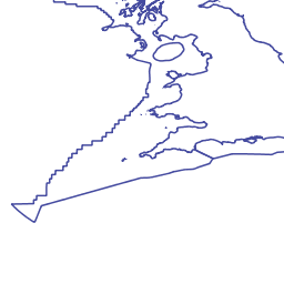
Administrative - Limits and Boundaries - Assessment areas - Marine Strategy Framework Directive (MSFD) UK sub regions (nmp:MSFD_CelticSeas_GreaterNorthSea)
For more information about this layer, including metadata and copyright details, please see http://marine.gov.scot/maps/860
There are currently no notifications for the service, click the feed icon to subscribe.