University of Hawaii, Manoa |
|
AZGS HIGS Geology
http://services.azgs.az.gov/arcgis/services/OneGeology/AZGS_HIGS_Geology/MapServer/WMSServer
| Service health Now: |
|---|
- Interface
- Web Service, OGC Web Map Service 1.3.0
- Keywords
- WMS, onegeology, geographicarea@United States, continent@Northern America, subarea@Hawaii, dataprovider@University of Hawaii, Manoa, serviceprovider@Arizona Geological Survey, Geology, Geologic Map, GeoSciML, onegeology, MD_DATE@2013-11-13, MD_LANG@eng, Geosciml_portrayal_age_or_litho_queryable
- Fees
- none
- Access constraints
- none
- Supported languages
- No INSPIRE Extended Capabilities (including service language support) given. See INSPIRE Technical Guidance - View Services for more information.
- Data provider
-
University of Hawaii, Manoa (unverified)
Contact information:
Nicole Lautze
University of Hawaii, Manoa
Office:
1680 East West Road, Post 602, 96822 Honolulu, United SatesEmail:
Phone: 808-956-3160
- Service metadata
- No INSPIRE Extended Capabilities (including service metadata) given. See INSPIRE Technical Guidance - View Services for more information.
Ads by Google
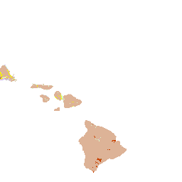
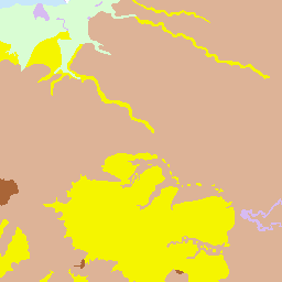
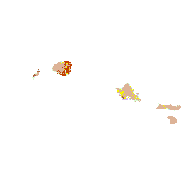
This service is compliant with Open Geospatial Consortium (OGC) standards and the data within is compatible with GeoSciML portrayal view for geoscience data. The source of the data in this service is the Hawaii Geological Survey. This web map service contains all the geologic map information used to publish U.S. Geological Survey Open-File Report 2007-1089 (Sherrod and others, 2007). The geologic map shows the distribution and stratigraphic relation of volcanic, intrusive, and sedimentary units emplaced in the past 8 million years across the eight principal islands of the Hawaiian archipelago, State of Hawaii, U.S.A. Two (2) layers are included in this service: 1. US-HI_HIGS_250k_Geologic_Age is a compilation dataset containing geologic units covering the state of Hawaii at a scale of 1:250,000; the table includes geologic name, description, lithology, and geologic history. The data in this layer is portrayed based on geologic age. 2. US-HI_HIGS_250k_Lithology is a compilation dataset containing geologic units covering the state of Hawaii at a scale of 1:250,000; the table includes geologic name, description, lithology, and geologic history. The data in this layer is portrayed based on lithology.See metadata record http://repository.stategeothermaldata.org/repository/resource/66bb6bbde013946035700d274f187fb5/ for more information on the dataset.
Available map layers (3)
AZGS HIGS Geology (AZGS_HIGS_Geology)
US-HI HIGS 1:250k Lithology (US-HI_HIGS_250k_Lithology)
US-HI_HIGS_250k_Lithology is a compilation dataset containing geologic units covering the state of Hawaii at a scale of 1:250,000; the table includes geologic name, description, lithology, and geologic history. The data in this layer is portrayed based on lithology.
US-HI HIGS 1:250k Geologic Age (US-HI_HIGS_250k_Geologic_Age)
US-HI_HIGS_250k_Geologic_Age is a compilation dataset containing geologic units covering the state of Hawaii at a scale of 1:250,000; the table includes geologic name, description, lithology, and geologic history. The data in this layer is portrayed based on geologic age.
There are currently no notifications for the service, click the feed icon to subscribe.