Regierungspraesidium Freiburg - Dept. … |
|
GeORG Gas storage data

| Service health Now: |
|---|
- Interface
- Web Service, OGC Web Map Service 1.3.0
- Keywords
- GeORG, gas storage, storage, cap rock
- Fees
- none
- Access constraints
- unknown
- Supported languages
- No INSPIRE Extended Capabilities (including service language support) given. See INSPIRE Technical Guidance - View Services for more information.
- Data provider
-
Regierungspraesidium Freiburg - Dept. 9 State Authority for Geology, Mineral Resources and Mining (unverified)
Contact information:
Guenter Sokol
Regierungspraesidium Freiburg - Dept. 9 State Authority for Geology, Mineral Resources and Mining
POSTAL:
Regierungspräsidium Freiburg - Abteilung 9 Landesamt für Geologie, Rohstoffe und Bergbau, Albertstraße 5, D-79104 Freiburg i. Br., D-79104 Freiburg i. Br., GermanyEmail:
Phone: +49 (0)761-208-3000
- Service metadata
- No INSPIRE Extended Capabilities (including service metadata) given. See INSPIRE Technical Guidance - View Services for more information.
Ads by Google
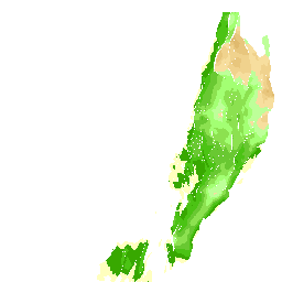
Interreg IV project "GeORG": Storage and cap rock potential maps for gas storage
Available map layers (67)
GeORG Gas storage data (lgrb_georg_store_en)
Interreg IV project "GeORG": Storage and cap rock potential maps for gas storage
Potential storage areas: Older Rhinegraben Tertiary (g_storebffbt)
The map shows the storage potential of the Older Rheingraben Tertiary for CO2 storage after common limits (depth of top and thickness of storage complex). The preferred range between 1000 and 2500 m below surface (depth top) is coloured separately. In addition the distribution of cap rock potential is shown, and the faults and fault zones at the top of the unit. For details see final report of INTERREG IV project "GeORG".
Areas with storage potential: Older Rhinegraben Tertiary (g_storebffbtg)
Areas without storage potential: Older Rhinegraben Tertiary (g_storeopbffbtf)
Cap rock potential: Older Rhinegraben Tertiary (g_barrmpbffbtf)
Occurance of Older Rhinegraben Tertiary (g_vgbffbtf_01)
Fault zones: Older Rhinegraben Tertiary (g_tecbfff-1_01)
Faults: Older Rhinegraben Tertiary (g_tecbffl-1_01)
Potential cap rock areas: Older Rhinegraben Tertiary (g_barrbffbt)
The map shows the cap rock potential of the Older Rheingraben Tertiary for CO2 storage after common limits (depth of top and thickness of cap rock complex). In addition faults and fault zones at base of the unit are shown. For details see final report of INTERREG IV project "GeORG".
Areas with Cap rock potential: Older Rhinegraben Tertiary (g_barrbffbtg)
Areas without cap rock potential: Older Rhinegraben Tertiary (g_barroptbffbtf)
Occurance of Older Rhinegraben Tertiary (g_vgbffbtf_02)
Fault zones: basement rocks (g_tecbbfff)
Faults:_ basement rocks (g_tecbbffl)
Potential storage areas: Malm (g_storejo)
The map shows the storage potential of Malm for CO2 storage after common limits (depth of top and thickness of storage complex). The preferred range between 1000 and 2500 m below surface (depth top) is coloured separately. In addition the distribution of cap rock potential is shown, and the faults and fault zones at the top of Malm. For details see final report of INTERREG IV project "GeORG".
Areas with storage potential: Malm (g_storejog)
Areas without storage potential: Malm (g_storeopjof)
Cap rock potential: Older Rhinegraben Tertiary (g_barrmpbffbtf_jo)
Occurance of Malm (g_vgjof)
Fault zones: Malm (g_tecbfff-1_02)
Faults: Malm (g_tecbffl-1_02)
Potential cap rock areas: Upper Dogger (g_barrbjothr)
The map shows the cap rock potential of the Upper Dogger for CO2 storage after common limits (depth of top and thickness of cap rock complex). In addition faults and fault zones at base of the unit are shown. For details see final report of INTERREG IV project "GeORG".
Areas with Cap rock potential: Upper Dogger (g_barrbjothrg)
Areas without cap rock potential: Upper Dogger (g_barropbjothrf)
Occurance of Main Oolite (g_vghrf)
Fault zone: Main Oolite (g_tecthrf)
Faults: Main Oolite (g_tecthrl)
Potential storage areas: Main Oolite (g_storehr)
The map shows the storage potential of the Main Oolite for CO2 storage after common limits (depth of top and thickness of storage complex). The preferred range between 1000 and 2500 m below surface (depth top) is coloured separately. In addition the distribution of cap rock potential is shown, and the faults and fault zones at the top of the Main Oolite. For details see final report of INTERREG IV project "GeORG".
Areas with storage potential: Main Oolite (g_storehrg)
Areas without storage potential: Main Oolite (g_storeophrf)
Cap rock potential: Oberer Mitteljura (g_barrmpthrbjof)
Occurance of Main Oolite (g_vghrf-1)
Fault zone: Main Oolite (g_tecthrf-1)
Faults: Main Oolite (g_tecthrl-1)
Potential cap rock areas: Keuper and Liassic (g_barrbjmbku)
The map shows the cap rock potential of the Keuper and Liassic for CO2 storage after common limits (depth of top and thickness of cap rock complex). In addition faults and fault zones at base of the unit are shown. For details see final report of INTERREG IV project "GeORG".
Areas with Cap rock potential: Keuper and Liassic (g_barrbjmbkug)
Areas without cap rock potential: Keuper and Liassic (g_barropbjmbkuf_01)
Occurance of Keuper and Liassic (g_vgbkuf)
Fault zone: Keuper and Liassic (g_tecbkuf)
Faults: Keuper and Liassic (g_tecbkul)
Potential storage areas: Upper Muschelkalk (g_storemo)
The map shows the storage potential of the Upper Muschelkalk for CO2 storage after common limits (depth of top and thickness of storage complex). The preferred range between 1000 and 2500 m below surface (depth top) is coloured separately. In addition the distribution of cap rock potential is shown, and the faults and fault zones at the top of the Upper Muschelkalk. For details see final report of INTERREG IV project "GeORG".
Areas with storage potential: Upper Muschelkalk (g_storemog)
Areas without storage potential: Upper Muschelkalk (g_storeopmof)
Cap rock potential: Keuper and Liassic (g_barropbjmbkuf_02)
Occurance of Upper Muschelkalk (g_vgmof)
Fault zone: Upper Muschelkalk (g_tectmof-2)
Faults: Upper Muschelkalk (g_tectmol-2)
Potential cap rock areas: Lower and Middle Muschelkalk (g_barrtmsbmu)
The map shows the cap rock potential of the Lower and Middle Muschelkalk for CO2 storage after common limits (depth of top and thickness of cap rock complex). In addition faults and fault zones at base of the unit are shown. For details see final report of INTERREG IV project "GeORG".
Areas with Cap rock potential: Lower and Middle Muschelkalk (g_barrtmsbmug)
Areas without cap rock potential: Lower and Middle Muschelkalk (g_barroptmsbmuf)
Occurance of Lower and Middle Muschelkalk (g_vgtmsbmuf)
Fault zone: Lower and Middle Muschelkalk (g_tecbmuf)
Faults: Lower and Middle Muschelkalk (g_tecbmul)
Potential storage areas: Permo-Triassic Sandstones (g_storesz)
The map shows the storage potential of the Permo-Triassic Sandstones for CO2 storage after common limits (depth of top and thickness of storage complex). The preferred range between 1000 and 2500 m below surface (depth top) is coloured separately. In addition the distribution of cap rock potential is shown, and the faults and fault zones at the top of the Permo-Triassic Sandstones. For details see final report of INTERREG IV project "GeORG".
Areas with storage potential: Permo-Triassic Sandstones (g_storeszg)
Areas without storage potential: Permo-Triassic Sandstones (g_storeopszf)
Cap rock potential: Lower and Middle Muschelkalk (g_barrmptmsbmuf)
Occurance of Permo-Triassic Sandstones (g_vgszf)
Fault zone: Permo-Triassic Sandstones (g_tectsf)
Faults: Permo-Triassic Sandstones (g_tectsl)
Potential storage areas: Permo-Carboniferous (g_storerco)
The map shows the storage potential of the Permo-Carboniferous for CO2 storage after common limits (depth of top and thickness of storage complex). The preferred range between 1000 and 2500 m below surface (depth top) is coloured separately. In addition the distribution of cap rock potential is shown, and the faults and fault zones at the top of the Permo-Carboniferous. For details see final report of INTERREG IV project "GeORG".
Areas with storage potential: Permo-Carboniferous (g_storercog)
Areas without storage potential: Permo-Carboniferous (g_storeoprcof)
Cap rock potential: Lower and Middle Muschelkalk (g_barrmptmsbmuf_rco)
Occurance of Permo-Carboniferoud (g_vgrcof)
Fault zone: Permo-Carboniferoud (g_tectrcof)
Faults: Permo-Carboniferoud (g_tectrcol)
There are currently no notifications for the service, click the feed icon to subscribe.