Regierungspraesidium Freiburg - Dept. … |
|
GeORG Geology data
| Service health Now: |
|---|
- Interface
- Web Service, OGC Web Map Service 1.3.0
- Keywords
- GeORG, Geology
- Fees
- none
- Access constraints
- unknown
- Supported languages
- No INSPIRE Extended Capabilities (including service language support) given. See INSPIRE Technical Guidance - View Services for more information.
- Data provider
-
Regierungspraesidium Freiburg - Dept. 9 State Authority for Geology, Mineral Resources and Mining (unverified)
Contact information:
Guenter Sokol
Regierungspraesidium Freiburg - Dept. 9 State Authority for Geology, Mineral Resources and Mining
POSTAL:
Regierungspräsidium Freiburg - Abteilung 9 Landesamt für Geologie, Rohstoffe und Bergbau, Albertstraße 5, D-79104 Freiburg i. Br., D-79104 Freiburg i. Br., GermanyEmail:
Phone: +49 (0)761-208-3000
- Service metadata
- No INSPIRE Extended Capabilities (including service metadata) given. See INSPIRE Technical Guidance - View Services for more information.
Ads by Google
In the framework of the European project "GeORG" (Geopotentials of the deep Upper Rhine Graben), partners from Switzerland, France and Germany prepared basic information on the subsurface of the Upper Rhine Graben and made them available to professionals as well as the interested public. GeORG has been financed by the Interreg IV Upper Rhine program from October 2008 to December 2012. This web service visualizes geology data prepared in the project and features the following layers: Geology at depth of 500 m below surface, Geology at depth of 1000 m below surface, Geology at depth of 1500 m below surface, Geology at depth of 2000 m below surface, Geology at depth of 2500 m below surface, Geology at depth of 3000 m below surface, Geology at depth of 3500 m below surface, Geology at depth of 4000 m below surface, Geology at depth of 4500 m below surface, Geology at depth of 5000 m below surface. Request on attributes provides additional information on spatial objects. The service is free of charge.
Available map layers (11)
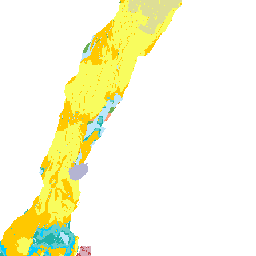
GeORG Geology data (lgrb_georg_geo_en)
In the framework of the European project "GeORG" (Geopotentials of the deep Upper Rhine Graben), partners from Switzerland, France and Germany prepared basic information on the subsurface of the Upper Rhine Graben and made them available to professionals as well as the interested public. GeORG has been financed by the Interreg IV Upper Rhine program from October 2008 to December 2012. This web service visualizes geology data prepared in the project and features the following layers: Geology at depth of 500 m below surface, Geology at depth of 1000 m below surface, Geology at depth of 1500 m below surface, Geology at depth of 2000 m below surface, Geology at depth of 2500 m below surface, Geology at depth of 3000 m below surface, Geology at depth of 3500 m below surface, Geology at depth of 4000 m below surface, Geology at depth of 4500 m below surface, Geology at depth of 5000 m below surface. Request on attributes provides additional information on spatial objects. The service is free of charge.
Geology at depth of 500 m below surface (g_geo500)
The map shows the geology in depth of 500 m below surface, derived from the geological 3D-Modell. Faults are not shown.
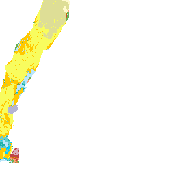
Geology at depth of 1000 m below surface (g_geo1000)
The map shows the geology in depth of 1000 m below surface, derived from the geological 3D-Modell. Faults are not shown.
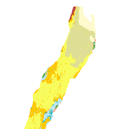
Geology at depth of 1500 m below surface (g_geo1500)
The map shows the geology in depth of 1500 m below surface, derived from the geological 3D-Modell. Faults are not shown.
Geology at depth of 2000 m below surface (g_geo2000)
The map shows the geology in depth of 2000 m below surface, derived from the geological 3D-Modell. Faults are not shown.
Geology at depth of 2500 m below surface (g_geo2500)
The map shows the geology in depth of 2500 m below surface, derived from the geological 3D-Modell. Faults are not shown.
Geology at depth of 3000 m below surface (g_geo3000)
The map shows the geology in depth of 3000 m below surface, derived from the geological 3D-Modell. Faults are not shown.
Geology at depth of 3500 m below surface (g_geo3500)
The map shows the geology in depth of 3500 m below surface, derived from the geological 3D-Modell. Faults are not shown.
Geology at depth of 4000 m below surface (g_geo4000)
The map shows the geology in depth of 4000 m below surface, derived from the geological 3D-Modell. Faults are not shown.
Geology at depth of 4500 m below surface (g_geo4500)
The map shows the geology in depth of 4500 m below surface, derived from the geological 3D-Modell. Faults are not shown.
Geology at depth of 5000 m below surface (g_geo5000)
The map shows the geology in depth of 5000 m below surface, derived from the geological 3D-Modell. Faults are not shown.
There are currently no notifications for the service, click the feed icon to subscribe.