Federal Institute for Geosciences and … |
|
| Service health Now: |
|---|
- Interface
- Web Service, OGC Web Map Service 1.3.0
- Keywords
- OneGeology, Geology, harmonized age, harmonized geologic units, Map, Germany, Age, Lithostratigraphy, Petrography, Genesis, Alter, Stratigraphie, Petrographie, Genese
- Fees
- none
- Access constraints
- Limitations of use: This map was derived and compiled from many larger scale data sources and has thus been generalized. It represents the generalized geological map (lithology, chronostratigraphy) of European off-shore areas at the scales of 1:1 million to 1:5 million, compiled from the contributions from the fourteen EMODnet1 project partners and large parts of the IGME 5000 GIS and database. Use of this information provided by the Bundesanstalt für Geowissenschaften und Rohstoffe (BGR) for the EMODnet1 project is at the users risk. In view of the disparate sources of information at BGR's disposal, which extensively includes material donated to BGR by EMODnet1 and IGME 5000 partners that BGR accepted in good face as being accurate, the BGR gives no warranty, expressed or implied, as to the quality or accuracy of the information supplied, or to the information's suitability for any use. BGR accepts no liability whatever in respect of loss, damage, injury or other occurence however caused. The data and information on this map are protected under the copyright of Bundesanstalt für Geowissenschaften und Rohstoffe (BGR). References: EMODnet project partners; IGME 5000: Asch, K. (2005): The 1 : 5 Million International Geological Map of Europe and Adjacent Areas. BGR (Hannover). Published by: Bundesanstalt für Geowissenschaften und Rohstoffe under the umbrella of the Commission of the Geological Map of the World, Subcommission for Europe.
- Supported languages
- No INSPIRE Extended Capabilities (including service language support) given. See INSPIRE Technical Guidance - View Services for more information.
- Data provider
-
Federal Institute for Geosciences and Natural Resources (unverified)
Contact information:
Dr. Kristine Asch
Federal Institute for Geosciences and Natural Resources
postal:
Stilleweg 2, 30655 Hannover, GermanyEmail:
Phone: +49-(0)511-643-3324
- Service metadata
- No INSPIRE Extended Capabilities (including service metadata) given. See INSPIRE Technical Guidance - View Services for more information.
Ads by Google
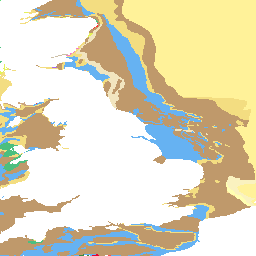
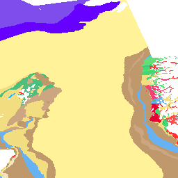
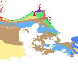
Seabed geology of the sub-Quaternary compiled for the WP 4 of the EMODnet project (lithology, chronostratigraphy). The geology covers the greater North Sea, Baltic Sea, Celtic Sea and parts of the North Atlantic Ocean.
Available map layers (3)
BGR Emodnet (DE_EMODNET)
Seabed geology of the sub-Quaternary compiled for the WP 4 of the EMODnet project (lithology, chronostratigraphy). The geology covers the greater North Sea, Baltic Sea, Celtic Sea and parts of the North Atlantic Ocean.
BGR Emodnet Lithology (BGR_Emodnet_lith)
This map was derived and compiled from many larger scale data sources and has thus been generalized. It represents lithology of European off-shore areas at the scales of 1:1 million to 1:5 million, compiled from the contributions from the fourteen EMODnet1 project partners and large parts of the IGME 5000 GIS and database. The geological feature types are transferred after the requirements of the OneGeology-Europe project (1GE); the lithology was mapped into 1GE_Lithology. A considerable part of the 1GE lithology vocabulary was adopted into the INSPIRE lithology vocabulary.
BGR Emodnet Stratigraphy (BGR_Emodnet_age)
This map was derived and compiled from many larger scale data sources and has thus been generalized. It represents the chronostratigraphy (age) of European off-shore areas at the scales of 1:1 million to 1:5 million, compiled from the contributions from the fourteen EMODnet1 project partners and large parts of the IGME 5000 GIS and database. The geological feature types are transferred after the requirements of the OneGeology-Europe project (1GE); the stratigraphic units were mapped into 1GE_Stratigraphy according to the International Stratigraphic Chart (ICS, IUGS, 2009).
There are currently no notifications for the service, click the feed icon to subscribe.