Delaware Geological Survey |
|
Delaware Geologic Information Resource WMS Server
http://maps.dgs.udel.edu:80/geoserver/DGS_Surficial_and_Contact_Geology/ows
| Service health Now: |
|---|
- Interface
- Web Service, OGC Web Map Service 1.3.0
- Keywords
- WMS, DGIR, groundwater, mapping, Delaware, OneGeology, MD_DATE@2012-12-21, MD_LANG@ENG, geology
- Fees
- NONE
- Access constraints
- NONE
- Supported languages
- No INSPIRE Extended Capabilities (including service language support) given. See INSPIRE Technical Guidance - View Services for more information.
- Data provider
-
Delaware Geological Survey (unverified)
Contact information:
DGS
Delaware Geological Survey
Office:
257 Academy St, 19716 Newark, USAEmail:
Phone: 302-831-2833
- Service metadata
- No INSPIRE Extended Capabilities (including service metadata) given. See INSPIRE Technical Guidance - View Services for more information.
Ads by Google
The Delaware Geological Survey (DGS) Delaware Geologic Information Resource (DGIR) map server. Built upon GeoServer, it is a compliant implementation of WMS plus most of the SLD extension (dynamic styling). Can also generate PDF, SVG, KML, GeoRSS.
Available map layers (2)
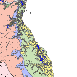
US-DE DGS 100k Surficial Geology (US-DE_DGS_100k_Surficial_Geology)
This map shows the surficial geology of Delaware, at a scale of 1:100,000. Sussex County is not published as yet so that county is mapped as Sand for the time being. Maps at this scale are useful for viewing general geologic framework on a county-wide basis, determining the geology of watersheds, and recognizing the relationship of geology to regional or county-wide environmental or land-use issues.
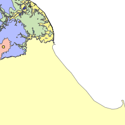
US-DE DGS 100k Surficial Geology Contacts (US-DE_DGS_100k_Surficial_Geology_Contacts)
This map shows the surficial geology contacts of Delaware, at a scale of 1:100,000, including state and county boundary lines and shorelines. Sussex County is not published as yet so that county is mapped as Sand for the time being. Maps at this scale are useful for viewing general geologic framework on a county-wide basis, determining the geology of watersheds, and recognizing the relationship of geology to regional or county-wide environmental or land-use issues.
There are currently no notifications for the service, click the feed icon to subscribe.