IRENA |
|
IRENA Web Map Service
| Service health Now: |
|---|
- Interface
- Web Service, OGC Web Map Service 1.3.0
- Keywords
- WFS, WMS, GEOSERVER
- Fees
- NONE
- Access constraints
- NONE
- Supported languages
- No INSPIRE Extended Capabilities (including service language support) given. See INSPIRE Technical Guidance - View Services for more information.
- Data provider
-
IRENA (unverified)
Contact information:
Jacinto Estima
IRENA
Business:
Masdar City, PO. Box 236 Abu Dhabi, United Arab EmiratesEmail:
- Service metadata
- No INSPIRE Extended Capabilities (including service metadata) given. See INSPIRE Technical Guidance - View Services for more information.
Ads by Google
Web Map Service that supports the IRENA Global Atlas for Renewable Energy
Available map layers (21)
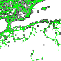
Global power lines, sub stations and generators OpenStreetMap 2015 extract (osm_global_power_network)
This map shows the power lines, substations and power generators for the whole world. The power lines have been reviewed for positional accuracy using google satellite maps. Most of the lines checked on the map, seem to correspond with the actual location lines as confirmed by high resolution aerial images from google satellite maps. Limitations on the dataset include incompleteness in certain areas, and less information on the voltage capacity of some of the lines. This dataset was extracted from the OpenStreetMap initiative. OpenStreetMap® is open data, licensed under the Open Data Commons Open Database License (ODbL) by the OpenStreetMap Foundation (OSMF). © OpenStreetMap contributors http://www.openstreetmap.org/copyright
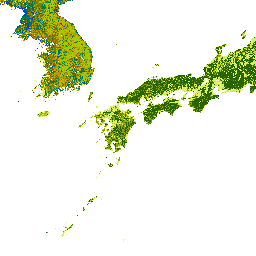
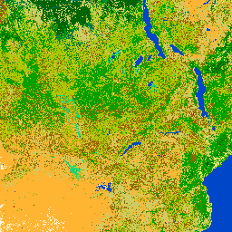
GlobCover land cover map world ESA 2009 (GLOBCOVER_L4_200901_200912_V2.3)
The European Space Agency's ESA GlobeCover is a global land cover map that has been produced in an automatic and global way and is associated with a legend defined and documented using the UN Land Cover Classification System (LCCS). The GlobCover 2009 land cover map is delivered as one global land cover map covering the entire Earth. Its legend, which counts 22 land cover classes, has been designed to be consistent at the global scale and therefore, it is determined by the level of information that is available and that makes sense at this scale.
global_dl_20140109 (aqueduct_global_dl_20140109)
Irena Officies (five_year_irena)
World country borders GADM (gadm_country_borders)
The global country boundaries layer has been produced using the Global Administrative Boundaries (GADM) database which is a comprehensive collection of spatial information on administrative areas all over the world. http://gadm.org/ The comprehensive GADM database covers countries and lower level subdivisions such as states, provinces, and counties.
World Geothermal Power Plants 2014 (geo_power_plants)
The Global Geothermal Plants database is a massive effort to provide an inventory of the existing geothermal plants all over the world. In this dataset, users would find for each geothermal plant; the plant name, the field name, the country and region where it is located, the name plate (installed) capacity, the operator and other relevant information. The dataset has been made available to the Global Renewable Energy Atlas by ThinkGeoEnergy (http://thinkgeoenergy.com). Kindly contact potentials@irena.org regarding any additional information or possible update of the dataset with any new plants you are aware of.
Global Heatflow database from the International Heat Flow Commission 2011 (global_heatflow)
Global heat flow data are maintained by the International Heat Flow Commission (IHFC) of the International Association of Seismology and Physics of the Earth's Interior (IASPEI). A new global compilation consisting of 35,523 continental heat flow points and 23,013 marine points. Last updated January 2011. Original website: http://www.heatflow.und.edu/index2.html
Global Geothermal Points Heat Flow IHFC 2015 (global_heatflow_2015)
The Global heat flow data are maintained by the International Heat Flow Commission (IHFC) of the International Association of Seismology and Physics of the Earth's Interior (IASPEI). The new global compilation covers over 50,000 heat flow data points. The contour lines and a raster have been developed from this data with help from the Royal Melbourne Institute of Technology (RMIT) in Melbourne, Australia. Original website http://www.heatflow.und.edu/index2.html
Global Lakes and Wetlands Database Level 3 world Bernhard Lehner 2004 (global_lakes_wetlands)
The Global Lakes and Wetlands Database draws upon a variety of existing maps, data and information. The combination of best available sources for lakes and wetlands on a global scale (1:1 to 1:3 million resolution), and the application of Geographic Information System (GIS) functionality enabled the generation the database which focuses on three coordinated levels: (1) large lakes and reservoirs, (2) smaller water bodies, and (3) wetlands.
Global Geothermal Contour Lines Heat Flow IHFC 2015 (heatflow_2015_contours)
The Global heat flow data are maintained by the International Heat Flow Commission (IHFC) of the International Association of Seismology and Physics of the Earth's Interior (IASPEI). The new global compilation covers over 50,000 heat flow data points. The contour lines and a raster have been developed from this data with help from the Royal Melbourne Institute of Technology (RMIT) in Melbourne, Australia. Original website http://www.heatflow.und.edu/index2.html
Global Geothermal Surface Heat Flow IHFC 2015 (heatflow_2015_raster)
The Global heat flow data are maintained by the International Heat Flow Commission (IHFC) of the International Association of Seismology and Physics of the Earth's Interior (IASPEI). The new global compilation covers over 50,000 heat flow data points. The contour lines and a raster have been developed from this data with help from the Royal Melbourne Institute of Technology (RMIT) in Melbourne, Australia. Original website http://www.heatflow.und.edu/index2.html
Global Population Database World 1km ORNL 2011 (lspop20111)
The LandScan 2011 Global Population Database was developed by Oak Ridge National Laboratory (ORNL) for the United States Department of Defense (DoD).
Global Population Database World 1km ORNL 2012 (lspop2012)
The LandScan 2012 Global Population Database was developed by Oak Ridge National Laboratory (ORNL) for the United States Department of Defense (DoD).
Change in population density every1km between 2011 and 2012 (lspop2012-2011)
Map of changes in population density between 2011 and 2012 based on LandScan 2011 and 2012 Global Population Database, developed by Oak Ridge National Laboratory (ORNL) for the United States Department of Defense (DoD).
Global Population Database World 1km ORNL 2013 (lspop2013)
The LandScan 2013 Global Population Database was developed by Oak Ridge National Laboratory (ORNL) for the United States Department of Defense (DoD).
Global Population Database World 1km ORNL 2014 (lspop2014)
The LandScan 2014 Global Population Database was developed by Oak Ridge National Laboratory (ORNL) for the United States Department of Defense (DoD).
Global Power Generators OpenStreetMap 2015 (osm_global_power_generators)
This map shows the power generators for the whole world. The power lines have been reviewed for positional accuracy using google satellite maps. Most of the lines checked on the map, seem to correspond with the actual location lines as confirmed by high resolution aerial images from google satellite maps. Limitations on the dataset include incompleteness in certain areas, and less information on the voltage capacity of some of the lines. This dataset was extracted from the OpenStreetMap initiative. OpenStreetMap® is open data, licensed under the Open Data Commons Open Database License (ODbL) by the OpenStreetMap Foundation (OSMF). © OpenStreetMap contributors http://www.openstreetmap.org/copyright
Global power lines OpenStreetMap 2015 extract (osm_global_power_lines)
This map shows the power lines for the whole world. The power lines have been reviewed for positional accuracy using google satellite maps. Most of the lines checked on the map, seem to correspond with the actual location lines as confirmed by high resolution aerial images from google satellite maps. Limitations on the dataset include incompleteness in certain areas, and less information on the voltage capacity of some of the lines. This dataset was extracted from the OpenStreetMap initiative. OpenStreetMap® is open data, licensed under the Open Data Commons Open Database License (ODbL) by the OpenStreetMap Foundation (OSMF). © OpenStreetMap contributors http://www.openstreetmap.org/copyright
Global sub stations OpenStreetMap 2015 extract (osm_global_power_stations)
This map shows the substations for the whole world. The power lines have been reviewed for positional accuracy using google satellite maps. Most of the lines checked on the map, seem to correspond with the actual location lines as confirmed by high resolution aerial images from google satellite maps. Limitations on the dataset include incompleteness in certain areas, and less information on the voltage capacity of some of the lines. This dataset was extracted from the OpenStreetMap initiative. OpenStreetMap® is open data, licensed under the Open Data Commons Open Database License (ODbL) by the OpenStreetMap Foundation (OSMF). © OpenStreetMap contributors http://www.openstreetmap.org/copyright
wind_power_wind_stations (wind_power_wind_stations)
World airports (world_airports)
Airports of the world
There are currently no notifications for the service, click the feed icon to subscribe.