Kentucky Geological Survey |
|
OneGeology_KGS_Kentucky_Geology_500K
http://kgs.uky.edu/arcgis/services/OneGeology/KYGS_Kentucky_Geology_500K/MapServer/WmsServer
| Service health Now: |
|---|
- Interface
- Web Service, OGC Web Map Service 1.3.0
- Keywords
- WMS, geographicarea@United States, continent@Northern America, subarea@Kentucky, dataprovider@Kentucky Geological Survey, serviceprovider@Kentucky Geological Survey, ArcGIS Server, Geology, Geologic Map, GeoSciML, onegeology, MD_DATE@2014-4-1, MD_LANG@eng, Geosciml_portrayal_age_or_litho_queryable
- Fees
- none
- Access constraints
- none
- Supported languages
- No INSPIRE Extended Capabilities (including service language support) given. See INSPIRE Technical Guidance - View Services for more information.
- Data provider
-
Kentucky Geological Survey (unverified)
Contact information:
Doug Curl
Kentucky Geological Survey
Office:
228 MMRB, University of Kentucky, 40506-0107 Lexington, USAEmail:
Phone: 859-323-0519
- Service metadata
- No INSPIRE Extended Capabilities (including service metadata) given. See INSPIRE Technical Guidance - View Services for more information.
Ads by Google
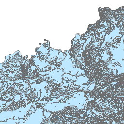
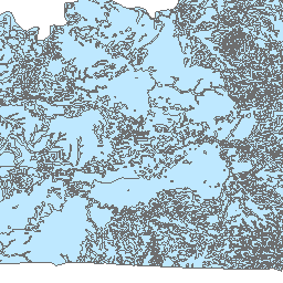
The Kentucky Geological Survey (KGS), as part of the United States Geoscience Information Network (USGIN), provides a compilation of geologic maps from the NGCMP-09 database (http://ngcmp.usgs.gov/) covering the United States of America including Hawaii and Alaska. This Service was published by the KGS as part of the USGIN initiative to “create and facilitate discovery and access to geoscience information provided by state and federal geological surveys of the United States”. These data were compiled by the Kentucky Geological Survey. Two (2) layers included in this service are as follows: 1. US-KY_KGS_500K_Geologic_Age is a compilation dataset containing geologic units covering the Commonwealth of Kentucky at 1:500,000 scale. The data table includes geologic name, description, lithology, and geologic history. The data in this layer is portrayed based on geologic age; 2. US-KY_KGS_500K_Lithology is a compilation datasets containing geologic units covering the Commonwealth of Kentucky at 1:500,000 scale. The table includes geologic name, description, lithology, and geologic history. The data in this layer is portrayed based on lithology; Citations are included in the dataset.
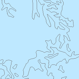
Available map layers (4)
Layer Group for SLD portrayal (SLD_layers)
One layer for use with SLD portrayal. Polygons will have a solid color and lines will have a solid single line for styling. Layer name= gsmlp2.0:geologicunitview
Geologic Unit Polygons (gsmlp2.0:geologicunitview)
US-KY_KGS_500K_Geologic_Age (US-KY_KGS_500K_Geologic_Age)
This layer provides a portrayal in which units are categorized according to the representative geologic age of the unit using the ICS 2009 geologic time scale. For units with extended histories, the representative age choice is interpretive, and typically the older bounding age is used in this portrayal. An SLD specifying the symbolization for this layer is at http://repository.azgs.az.gov/resources/slds/xml/GeologicAgeIUGS2009URI.sld
US-KY_KGS_500K_Lithology (US-KY_KGS_500K_Lithology)
Portrayal in which units are categorized according to the representative lithology from the CGI SimpleLithology vocabulary as specified by the representativeLithology_URI property in the underlying dataset. The data in this layer are portrayed based on lithology using the color scheme encoded in http://repository.azgs.az.gov/resources/slds/xml/LithologyCGI201001URI.sld. See https://www.seegrid.csiro.au/wiki/CGIModel/ConceptDefinitionsTG for OneGeology data integration by SM Richard.
There are currently no notifications for the service, click the feed icon to subscribe.