Landesamt für Vermessung und Geoinform… |
|

| Service health Now: |
|---|
- Interface
- Web Service, OGC Web Map Service 1.3.0
- Keywords
- Fees
- none
- Access constraints
- unknown
- Supported languages
- No INSPIRE Extended Capabilities (including service language support) given. See INSPIRE Technical Guidance - View Services for more information.
- Data provider
-
Landesamt für Vermessung und Geoinformation Vorarlberg (unverified)
Contact information:
N.N.
Landesamt für Vermessung und Geoinformation Vorarlberg
postal:
Johannitergasse 6, A-6800 Feldkirch, ATEmail:
Phone: +43 (0)5522 75482
- Service metadata
- No INSPIRE Extended Capabilities (including service metadata) given. See INSPIRE Technical Guidance - View Services for more information.
Ads by Google
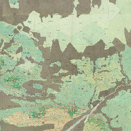
Geodaten des Bundeslandes Vorarlberg als OGC-WMS
Available map layers (14)
Urmappe (MS)
Geodaten des Bundeslandes Vorarlberg als OGC-WMS
Negrelli_Rheinstromkarte_1826_25cm (negrelli_rheinstromkarte_1826_25cm)
Negrelli_Illkarte_Feldkirch_bis_Nueziders (negrelli_illkarte_feldkirch_bis_nueziders)
Negrelli_Illkarte_Bereich_Schruns (negrelli_illkarte_bereich_schruns)
Urmappe (urmappe)
3LA_1871-1872 (3LA_1871-1872)
3RA_1887 (3RA_1887)
SPZ_1908-1915 (SPZ_1908-1915)
SPZ_1934-1937 (SPZ_1934-1937)
Oesterr. Karte 1:50000 1946 - 1947 (OEK50_Prov_1946-47)
Oesterr. Karte 1:50000 1953-1967 (OEK50_1953-1967)
oek50_1961-1974 (oek50_1961-1974)
Oesterr. Karte 1:50000 1971-1980 (OEK50_1971-1980)
Gewaesserkarte_gk_5m (Gewaesserkarte_gk_5m)
There are currently no notifications for the service, click the feed icon to subscribe.