Geological Survey of Finland GTK |
|
GTK_Bedrock_and_Superficial_Geology
http://geomaps2.gtk.fi/arcgis/services/GTK_Bedrock_and_Superficial_Geology2/MapServer/WMSServer
| Service health Now: |
|---|
- Interface
- Web Service, OGC Web Map Service 1.3.0
- Keywords
- Finland, GTK, OneGeology, OneGeology-Europe, geology, bedrock, superficial, WMS
- Fees
- none
- Access constraints
- Copyright Geological Survey of Finland 2009. The service is available for free personal, teaching, research or non-commercial use. By accessing and using thise WMS/WFS services of the Geological Survey of Finland (GTK), you agree to the terms and conditions. All material including text, images and audiovisual elements is protected by copyright laws, other applicable laws, treaties and agreements.
- Supported languages
- No INSPIRE Extended Capabilities (including service language support) given. See INSPIRE Technical Guidance - View Services for more information.
- Data provider
-
Geological Survey of Finland GTK (unverified)
Contact information:
Mikko Nironen
Geological Survey of Finland GTK
Email:
- Service metadata
- No INSPIRE Extended Capabilities (including service metadata) given. See INSPIRE Technical Guidance - View Services for more information.
Ads by Google
GTK_Bedrock_and_Superficial_Geology
Available map layers (3)
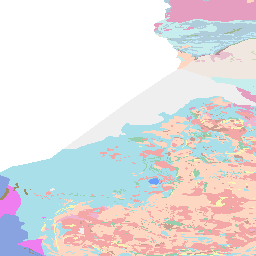
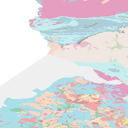
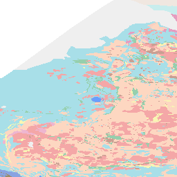
FIN GTK 1:1M Bedrock Lithology (0)
This dataset shows bedrock areas defined by rock types and ages covering onshore areas of Finland. The bedrock areas are also assigned to tectonic units. The map is composed of data resulting from several mapping campaigns, performed over decades, compiled and archived in digital format, published or prepared in manuscript format between 1989 and 2001. Due to the variation of quality and scales of different mapping campaigns the level of accuracy in the underlying national database is variable. The database is designed for presentation in the 1:1M scale.
FIN GTK 1:1M Bedrock Lithology Dykes (1)
This dataset shows dyke swarms defined by rock types and ages. The map is composed of data resulting from several mapping campaigns, performed over decades, compiled and archived in digital format, published or prepared in manuscript format between 1989 and 2001. Due to the variation of quality and scales of different mapping campaigns the level of accuracy in the underlying national database is variable. The database is designed for presentation in the 1:1M scale.
FIN GTK 1:1M Superficial Lithology (2)
FIN GTK 1:1M Superficial Lithology
There are currently no notifications for the service, click the feed icon to subscribe.