Federal Institute for Geosciences and … |
|
BGR Groundwater: IHME1500

| Service health Now: |
|---|
- Interface
- Web Service, OGC Web Map Service 1.3.0
- Keywords
- geodata, geo information system, groundwater, hydrogeology, map, raster data, water, WMS, Web Map Service, OGC, Open GIS, web mapping, GIS, IHME1500, IHME 1500
- Fees
- NONE
- Access constraints
- Allgemeine Geschäftsbedingungen, siehe http://www.bgr.bund.de/AGB - General terms and conditions, see http://www.bgr.bund.de/AGB_en. Die bereitgestellten Informationen sind bei Weiterverwendung wie folgt zu zitieren: Datenquelle: IHME1500, (C) BGR & UNESCO, 1970-2013
- Supported languages
- No INSPIRE Extended Capabilities (including service language support) given. See INSPIRE Technical Guidance - View Services for more information.
- Data provider
-
Federal Institute for Geosciences and Natural Resources (BGR) (unverified)
Contact information:
Klaus Duscher
Federal Institute for Geosciences and Natural Resources (BGR)
postal:
Wilhelmstr. 25 -30, 13593 Berlin, GermanyEmail:
Phone: +49-30-36993-265
- Service metadata
- No INSPIRE Extended Capabilities (including service metadata) given. See INSPIRE Technical Guidance - View Services for more information.
Ads by Google
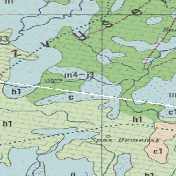
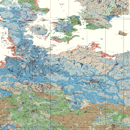
The International Hydrogeological Map of Europe, scale 1:1,500,000 is a series of general hydrogeological maps comprising 25 map sheets with explanatory notes, covering the whole European continent and parts of the Near East. The national contributions to this map series were compiled by hydrogeologists and experts in related sciences of the countries concerned under the auspices of the International Association of Hydrogeologists (IAH) and its Commission on Hydrogeological Maps (COHYM). The project is supported by the Commission for the Geological Map of the World (CGMW). The scientific editorial work is supported financially by the Government of the Federal Republic of Germany through the Bundesanstalt für Geowissenschaften und Rohstoffe (BGR) and by the United Nations Educational, Scientific and Cultural Organization (UNESCO). These organizations are responsible for the cartography, printing and publication of the map sheets and explanatory notes. The series of hydrogeological maps seeks to represent the hydrogeological setting of Europe as a whole without regard to political boundaries. Together with the information presented in the accompanying explanatory notes, the map can be used for scientific purposes, for large-scale regional planning and as a basis for detailed hydrogeological mapping. Internet: http://www.bgr.bund.de/ihme1500/
Available map layers (6)
BGR Groundwater: IHME1500 (bgr_grundwasser_ihme1500)
The International Hydrogeological Map of Europe, scale 1:1,500,000 is a series of general hydrogeological maps comprising 25 map sheets with explanatory notes, covering the whole European continent and parts of the Near East. The national contributions to this map series were compiled by hydrogeologists and experts in related sciences of the countries concerned under the auspices of the International Association of Hydrogeologists (IAH) and its Commission on Hydrogeological Maps (COHYM). The project is supported by the Commission for the Geological Map of the World (CGMW). The scientific editorial work is supported financially by the Government of the Federal Republic of Germany through the Bundesanstalt für Geowissenschaften und Rohstoffe (BGR) and by the United Nations Educational, Scientific and Cultural Organization (UNESCO). These organizations are responsible for the cartography, printing and publication of the map sheets and explanatory notes. The series of hydrogeological maps seeks to represent the hydrogeological setting of Europe as a whole without regard to political boundaries. Together with the information presented in the accompanying explanatory notes, the map can be used for scientific purposes, for large-scale regional planning and as a basis for detailed hydrogeological mapping. Internet: http://www.bgr.bund.de/ihme1500/
IHME1500, map sheets (ihme_sheets)
International Hydrogeological Map of Europe 1:1,500,000 (IHME1500), 25 map sheets
IHME1500, map index (ihme_index)
International Hydrogeological Map of Europe 1:1,500,000 (IHME1500), map index
IHME1500, map index code (ihme_index_code)
International Hydrogeological Map of Europe 1:1,500,000 (IHME1500), map index code
IHME1500, map index name (ihme_index_name)
International Hydrogeological Map of Europe 1:1,500,000 (IHME1500), map index name
IHME1500, year of publication (ihme_year_publication)
International Hydrogeological Map of Europe 1:1,500,000 (IHME1500), year of publication
There are currently no notifications for the service, click the feed icon to subscribe.