Food and Agriculture Organization (FAO) |
|
FAO GeoNetwork OGC Web Map Server


| Service health Now: |
|---|
- Interface
- Web Service, OGC Web Map Service 1.1.1
- Keywords
- FAO, WMS, OGC, GeoNetwork
- Fees
- none
- Access constraints
- none
- Data provider
-
Food and Agriculture Organization (FAO) (unverified)
Contact information:
Jeroen Ticheler
Food and Agriculture Organization (FAO)
postal:
Viale delle Terme di Caracalla, 1, 00153 Rome, ItalyEmail:
Phone: +39-06 57051
Ads by Google
Available map layers (5)
FAO GeoNetwork OGC Web Map Server (GNW)
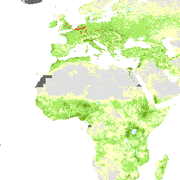
Map 2.2: Rural population density - persons per square kilometer - 2000 (Map 2.2: Rural population density - persons per square kilometer - 2000)
Map 2.2: Rural population density - persons per square kilometer - 2000
Rural population density (persons per square kilometre), 2000 (rural_population_density_2000)
The dataset shows the density of rural people as person per square kilometre. It is contained in Food Insecurity, Poverty and Environment Global GIS Database (FGGD) and is presented in the Module 2 of the hardcopy atlas (FAO, 2006). For further detail on this dataset see
Country Boundaries (Country Boundaries)
Country Boundaries
Coastal and country boundaries of the world (country_bnd)
Country boundaries map derived from the country boundaries on the Digitized Soil Map of the World. Updated up to 2005.
There are currently no notifications for the service, click the feed icon to subscribe.