Department of Natural Resources and Mi… |
|
Queensland Topographic Map Lite Web Map Service
https://geospatial.information.qld.gov.au/ArcGIS/services/QLD/QTopoBaseLite_WebM/MapServer/WMSServer

| Service health Now: |
|---|
- Interface
- Web Service, OGC Web Map Service 1.3.0
- Keywords
- topographic, place, population centre, builtup area, airport, police station, pipelines, homestead, building, dam, dam wall, powerline, point of interest, local government, locality, marine park, cadastral parcel, cadastre, roads, tracks, trails, railway station, railway line, peak, range, sand, sand ridges, marine hazards, beach, cliff, contour, hillshade, watercourse, waterbody, lake, reservoir, pondage area, caanal, reef, shoal, wetland, vegetation, Queensland
- Fees
- Nil
- Access constraints
-
Service is supported 8:30am - 4:30pm on business days and is generally available at other times.

This service is free to use and is licensed under a Creative Commons - Attribution 3.0 Australia licence.
The Department of Natural Resources and Mines requests attribution in the following manner:
© State of Queensland (Department of Natural Resources and Mines) 2013. - Supported languages
- No INSPIRE Extended Capabilities (including service language support) given. See INSPIRE Technical Guidance - View Services for more information.
- Data provider
-
Department of Natural Resources and Mines (unverified)
Contact information:
Department of Natural Resources and Mines
GPO Box 2454, 4001 Brisbane, Australia
Email:
- Service metadata
- No INSPIRE Extended Capabilities (including service metadata) given. See INSPIRE Technical Guidance - View Services for more information.
Ads by Google
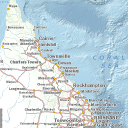
The Queensland Topographic Data service is based on data acquired and collated by the Department of Natural Resources and Mines, Queensland for more than thirty years. This data is used primarily for the creation of the 1:25 000 Topographic Map Series covering various parts of Queensland. The service uses a map cache created for the following scales: 1:18,084, 1:36,112, 1:72,224, 1:144,448, 1:288,895, 1:577,791, 1:1,155,581, 1:2,311,162, 1:4,622,324 and 1:9,244,649. The map cache will be refreshed periodically to show updated data.
Available map layers (1)
Queensland_Topographic_Map_Cache_Lite (Queensland_Topographic_Map_Cache_Lite)
The Queensland Topographic Data service is based on data acquired and collated by the Department of Natural Resources and Mines, Queensland for more than thirty years. This data is used primarily for the creation of the 1:25 000 Topographic Map Series covering various parts of Queensland. The service uses a map cache created for the following scales: 1:18,084, 1:36,112, 1:72,224, 1:144,448, 1:288,895, 1:577,791, 1:1,155,581, 1:2,311,162, 1:4,622,324 and 1:9,244,649. The map cache will be refreshed periodically to show updated data.
There are currently no notifications for the service, click the feed icon to subscribe.