Food and Agriculture Organization (FAO) |
|
FAO GeoNetwork OGC Web Map Server

| Service health Now: |
|---|
- Interface
- Web Service, OGC Web Map Service 1.1.1
- Keywords
- FAO, WMS, OGC, GeoNetwork
- Fees
- none
- Access constraints
- none
- Data provider
-
Food and Agriculture Organization (FAO) (unverified)
Contact information:
Jeroen Ticheler
Food and Agriculture Organization (FAO)
postal:
Viale delle Terme di Caracalla, 00153 Rome, ItalyEmail:
Phone: +39-06 57051
Ads by Google
Available map layers (2)
FAO GeoNetwork OGC Web Map Server (GNW)
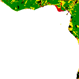
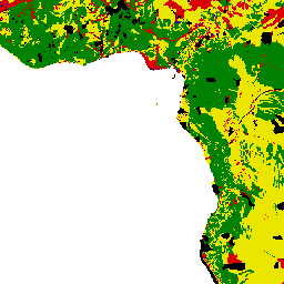
Soil and terrain suitability for ponds (soil_terrain_suitability_ponds)
Suitable areas for the construction of fishponds based on the combined suitability of soils and slopes. Soils evaluation was based on FAO's Digital Soil Map of the World (DSMW) and included: texture, effective soil depth, pH, salinity, and the presence of catclays and gypsum. Slope was derived from a global digital elevation model (GTOPOP30) in the form of percentages. To consider the combined suitability of soils and slopes, it was considered that the former were more important than the latter. This was because suitable soils would ensure two of the most important engineering capability factors for pond construction: good water retention and good pond fertility.
There are currently no notifications for the service, click the feed icon to subscribe.