Food and Agriculture Organization (FAO) |
|
FAO GeoNetwork OGC Web Map Server
| Service health Now: |
|---|
- Interface
- Web Service, OGC Web Map Service 1.1.1
- Keywords
- FAO, WMS, OGC, GeoNetwork
- Fees
- none
- Access constraints
- none
- Data provider
-
Food and Agriculture Organization (FAO) (unverified)
Contact information:
Jeroen Ticheler
Food and Agriculture Organization (FAO)
postal:
Viale delle Terme di Caracalla, 00153 Rome, ItalyEmail:
Phone: +39-06 57051
Ads by Google
Available map layers (2)
FAO GeoNetwork OGC Web Map Server (GNW)
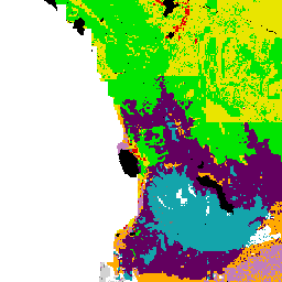
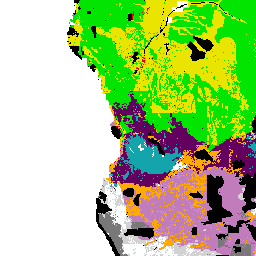
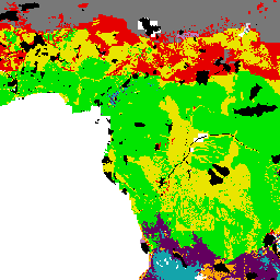
Suitability for small-scale farming and potential yield (crops/y) of Nile tilapia (suitability_farming_potential_yield_tilapia)
Map derived from the combined suitability of areas apt for small-scale fish farming development and operation with areas with potential yield (crops/y) of Nile tilapia for small-scale farming. Areas with suitability for small-scale fish farming were derived from the combined suitability of four land-quality factors important for fish farming development and operation; net annual water requirement for shallow ponds, soil and terrain suitability for the construction of fish ponds, potential livestock wastes and agriculture by-products as feed and fertilizer inputs, and potential for farm-gate sales. Predictions of growth were based on water temperature, in turn predicted from air temperature and wind velocity data. Gridded values of mean monthly daily minimum and maximum temperatures were obtained from the Centre for Resource and Environmental Studies (CRES) at the Australian National University. Mean annual wind velocity was obtained from UNEP/DEIA/GRID-Geneva.
There are currently no notifications for the service, click the feed icon to subscribe.