Food and Agriculture Organization (FAO) |
|
FAO GeoNetwork OGC Web Map Server

| Service health Now: |
|---|
- Interface
- Web Service, OGC Web Map Service 1.1.1
- Keywords
- FAO, WMS, OGC, GeoNetwork
- Fees
- none
- Access constraints
- none
- Data provider
-
Food and Agriculture Organization (FAO) (unverified)
Contact information:
Jeroen Ticheler
Food and Agriculture Organization (FAO)
postal:
Viale delle Terme di Caracalla, 00153 Rome, ItalyEmail:
Phone: +39-06 57051
Ads by Google
Available map layers (2)
FAO GeoNetwork OGC Web Map Server (GNW)
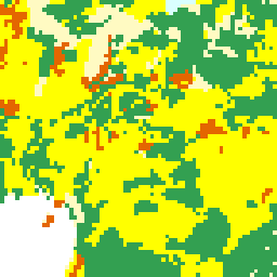
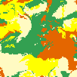
Engineering capability (engineering_capability)
Engineering capability for pond construction obtained by combining soil texture and slope. Soil texture was interpreted in terms of suitability for pond construction. Soil texture data was obtained from the FAO-UNESCO Soil Map of Africa at 1:5 million scale. This dataset includes three soil texture classes: coarse, medium and fine and these are given for the dominant soils of each association and refer only to the upper 30cm. Slope was interpreted in terms of suitability of topography for pond construction. Slope data was also obtained from the FAO-UNESCO Soil Map of Africa at 1:5 million scale. This dataset includes three slopes classes which reflect the topography in which the soil association occurs.
There are currently no notifications for the service, click the feed icon to subscribe.