Food and Agriculture Organization (FAO) |
|
FAO GeoNetwork OGC Web Map Server

| Service health Now: |
|---|
- Interface
- Web Service, OGC Web Map Service 1.1.1
- Keywords
- FAO, WMS, OGC, GeoNetwork
- Fees
- none
- Access constraints
- none
- Data provider
-
Food and Agriculture Organization (FAO) (unverified)
Contact information:
Jeroen Ticheler
Food and Agriculture Organization (FAO)
postal:
Viale delle Terme di Caracalla, 00153 Rome, ItalyEmail:
Phone: +39-06 57051
Ads by Google
Available map layers (2)
FAO GeoNetwork OGC Web Map Server (GNW)
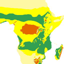
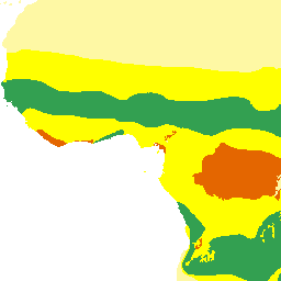
Inputs (inputs_africa)
Productivity and variety of crops interpreted as availability of agricultural by products as inputs for fish farming. The objective of this map is to indicate the locations, availability and variety of agricultural by-products that could be used as inputs for fish farming. These can be related to agronomic suitability as measured by the length of growing period (LGP). Agro-ecological zones for 11 crops were defined for Africa by FAO (1978). LGP was calculated from data collected from 730 stations and plotted at 30-day intervals at 1:5 million scale.
There are currently no notifications for the service, click the feed icon to subscribe.