Food and Agriculture Organization (FAO) |
|
FAO GeoNetwork OGC Web Map Server

| Service health Now: |
|---|
- Interface
- Web Service, OGC Web Map Service 1.1.1
- Keywords
- FAO, WMS, OGC, GeoNetwork
- Fees
- none
- Access constraints
- none
- Data provider
-
Food and Agriculture Organization (FAO) (unverified)
Contact information:
Jeroen Ticheler
Food and Agriculture Organization (FAO)
postal:
Viale delle Terme di Caracalla, 00153 Rome, ItalyEmail:
Phone: +39-06 57051
Ads by Google
Available map layers (2)
FAO GeoNetwork OGC Web Map Server (GNW)
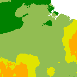
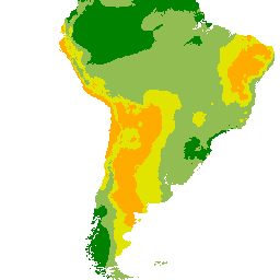
Net annual water loss from ponds through evaporation and seepage (water_loss_through_evaporation_seepage)
Spatial distribution of net annual water loss from ponds through evaporation and seepage. The water balance for fishponds was calculated by estimating the deficit between precipitation and combined evaporation plus seepage. Evaporation was calculated using the Hargreaves formula (i.e. mean monthly minimum and maximum air temperature data were provided by FAO) and seepage was a constant.
There are currently no notifications for the service, click the feed icon to subscribe.