British Geological Survey (BGS) |
|
BGS Bedrock and Superficial geology
http://ogc.bgs.ac.uk/cgi-bin/BGS_Bedrock_and_Superficial_Geology/ows
| Service health Now: |
|---|
- Interface
- Web Service, OGC Web Map Service 1.3.0
- Keywords
- OneGeology, MD_LANG@ENG, MD_DATE@2019-02-05, Geology, infoMapAccessService
- Fees
- none
- Access constraints
- The 1:625k DiGMap data is made available for all uses - including commercial use, however the British Geological Survey (BGS) at all times retains the copyright in this material and you are not permitted, without an appropriate licence, to set up a service selling on this material. Your own use of any information provided by the British Geological Survey (BGS) is at your own risk. Neither BGS nor the Natural Environment Research Council (NERC) gives any warranty, condition or representation as to the quality, accuracy or completeness of the information or its suitability for any use or purpose. All implied conditions relating to the quality or suitability of the information, and all liabilities arising from the supply of the information (including any liability arising in negligence) are excluded to the fullest extent permitted by law.
- Supported languages
- eng
- Data provider
-
British Geological Survey (BGS) (unverified)
Contact information:
Mr Garry Baker
British Geological Survey (BGS)
postal:
Nicker Hill, NG12 5GG Keyworth, United KingdomEmail:
Phone: +44 (0)115 936 3100
- Service metadata
Ads by Google
The 1:625k DiGMap data covering the whole of the United Kingdom is available in this OGC WMS service for all uses - including commercial use subject to the conditions in the Access Constraints section. It is being served as a contribution to the OneGeology initiative (onegeology.org). Separate bedrock geology and superficial deposits layers are available in this service. Layers available for bedrock are lithostratigraphy, age, and lithology. Layers available for superficial deposits layer are lithostratigraphy and lithology. A layer is also provided for the UK Continental Shelf BGS 1:1M simplified seabed sediments. For information about more of the British Geological Survey's maps that are available digitally please visit https://www.bgs.ac.uk/information-hub/bgs-maps-portal/
Available map layers (7)
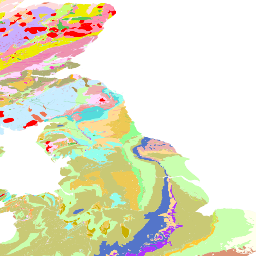
BGS bedrock and superficial geology (BGS_EN_Bedrock_and_Superficial_Geology)
The 1:625k DiGMap data covering the whole of the United Kingdom is available in this OGC WMS service for all uses - including commercial use subject to the conditions in the Access Constraints section. It is being served as a contribution to the OneGeology initiative (onegeology.org). Separate bedrock geology and superficial deposits layers are available in this service. Layers available for bedrock are lithostratigraphy, age, and lithology. Layers available for superficial deposits layer are lithostratigraphy and lithology. A layer is also provided for the UK Continental Shelf BGS 1:1M simplified seabed sediments. For information about more of the British Geological Survey's maps that are available digitally please visit https://www.bgs.ac.uk/information-hub/bgs-maps-portal/
GBR BGS 1:625k Bedrock Lithology (GBR_BGS_625k_BLT)
GBR BGS 1:625k scale Bedrock Lithology
GBR BGS 1:625k Bedrock Lithostratigraphy (GBR_BGS_625k_BLS)
GBR BGS 1:625k scale Bedrock Lithostratigraphy (including Lithogenic units)
GBR BGS 1:625k Bedrock Age (GBR_BGS_625k_BA)
GBR BGS 1:625k scale Bedrock Age
GBR BGS 1:625k Superficial Lithology (GBR_BGS_625k_SLT)
GBR BGS 1:625k scale Superficial Deposits Lithology
GBR BGS 1:625k Superficial Lithostratigraphy (GBR_BGS_625k_SLS)
GBR BGS 1:625k scale Superficial Deposits Lithostratigraphy (including Lithomorphogenetic units)
UKContShelf BGS 1:1M Seabed Sediments (UKCoShelf_BGS_1M_SBS)
UKContShelf BGS 1:1M Seabed Sediments. Your use of any information provided by the British Geological Survey (BGS) is at your own risk. Neither BGS nor the Natural Environment Research Council (NERC) gives any warranty, condition or representation as to the quality, accuracy or completeness of the information or its suitability for any use or purpose. All implied conditions relating to the quality or suitability of the information, and all liabilities arising from the supply of the information (including any liability arising in negligence) are excluded to the fullest extent permitted by law.
There are currently no notifications for the service, click the feed icon to subscribe.