IRENA |
|
IRENA Web Map Service


| Service health Now: |
|---|
- Interface
- Web Service, OGC Web Map Service 1.3.0
- Keywords
- WFS, WMS, GEOSERVER
- Fees
- NONE
- Access constraints
- NONE
- Supported languages
- No INSPIRE Extended Capabilities (including service language support) given. See INSPIRE Technical Guidance - View Services for more information.
- Data provider
-
IRENA (unverified)
Contact information:
Jacinto Estima
IRENA
Business:
Masdar City, PO. Box 236 Abu Dhabi, United Arab EmiratesEmail:
- Service metadata
- No INSPIRE Extended Capabilities (including service metadata) given. See INSPIRE Technical Guidance - View Services for more information.
Ads by Google
Web Map Service that supports the IRENA Global Atlas for Renewable Energy
Available map layers (8)
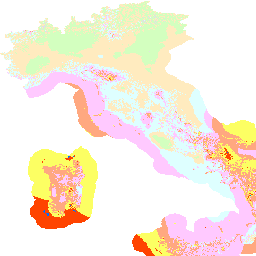
Annual Specific Production at 100m a.g.l./a.s.l. (grid_nazionale_prod100)
Source: RSE S.p.A. Website: www.rse-web.it Description: Annual mean wind speed and specific production maps at four levels (25, 50, 75 and 100 m) above ground and sea, with 1 km spatial resolution, are available in a WebGIS for navigation and free download. The maps have been calculated by means of the WINDS model of Genoa University. The onshore maps have been calibrated with more than 200 met stations data, the offshore maps with satellite data and few available direct measurements. Constraints maps can be overlapped. A “Performance Calculation” tool allows the user to perform a technical-economical evaluation of hypothesis of wind farms based on the dataset of the Wind Atlas. Detailed description: http://irena.masdar.ac.ae/docs/OWEMES_Italian_wind_atlas_english_version_paper.pdf Original website: http://atlanteeolico.rse-web.it/viewer.htm Please access he data quality information for this dataset at: http://globalatlas.irena.org/dqif/publishdata.aspx?datasetid=3034. Also for additional information please download the data quality framework report at: goo.gl/T2wMaq
Annual Specific Production at 25m a.g.l./a.s.l. (grid_nazionale_prod25)
Source: RSE S.p.A. Website: www.rse-web.it Description: Annual mean wind speed and specific production maps at four levels (25, 50, 75 and 100 m) above ground and sea, with 1 km spatial resolution, are available in a WebGIS for navigation and free download. The maps have been calculated by means of the WINDS model of Genoa University. The onshore maps have been calibrated with more than 200 met stations data, the offshore maps with satellite data and few available direct measurements. Constraints maps can be overlapped. A “Performance Calculation” tool allows the user to perform a technical-economical evaluation of hypothesis of wind farms based on the dataset of the Wind Atlas. Detailed description: http://irena.masdar.ac.ae/docs/OWEMES_Italian_wind_atlas_english_version_paper.pdf Original website: http://atlanteeolico.rse-web.it/viewer.htm Please access he data quality information for this dataset at: http://globalatlas.irena.org/dqif/publishdata.aspx?datasetid=3034. Also for additional information please download the data quality framework report at: goo.gl/T2wMaq
Annual Specific Production at 50m a.g.l./a.s.l. (grid_nazionale_prod50)
Source: RSE S.p.A. Website: www.rse-web.it Description: Annual mean wind speed and specific production maps at four levels (25, 50, 75 and 100 m) above ground and sea, with 1 km spatial resolution, are available in a WebGIS for navigation and free download. The maps have been calculated by means of the WINDS model of Genoa University. The onshore maps have been calibrated with more than 200 met stations data, the offshore maps with satellite data and few available direct measurements. Constraints maps can be overlapped. A “Performance Calculation” tool allows the user to perform a technical-economical evaluation of hypothesis of wind farms based on the dataset of the Wind Atlas. Detailed description: http://irena.masdar.ac.ae/docs/OWEMES_Italian_wind_atlas_english_version_paper.pdf Original website: http://atlanteeolico.rse-web.it/viewer.htm Please access he data quality information for this dataset at: http://globalatlas.irena.org/dqif/publishdata.aspx?datasetid=3034. Also for additional information please download the data quality framework report at: goo.gl/T2wMaq
Annual Specific Production at 75m a.g.l./a.s.l. (grid_nazionale_prod75)
Source: RSE S.p.A. Website: www.rse-web.it Description: Annual mean wind speed and specific production maps at four levels (25, 50, 75 and 100 m) above ground and sea, with 1 km spatial resolution, are available in a WebGIS for navigation and free download. The maps have been calculated by means of the WINDS model of Genoa University. The onshore maps have been calibrated with more than 200 met stations data, the offshore maps with satellite data and few available direct measurements. Constraints maps can be overlapped. A “Performance Calculation” tool allows the user to perform a technical-economical evaluation of hypothesis of wind farms based on the dataset of the Wind Atlas. Detailed description: http://irena.masdar.ac.ae/docs/OWEMES_Italian_wind_atlas_english_version_paper.pdf Original website: http://atlanteeolico.rse-web.it/viewer.htm Please access he data quality information for this dataset at: http://globalatlas.irena.org/dqif/publishdata.aspx?datasetid=3034. Also for additional information please download the data quality framework report at: goo.gl/T2wMaq
Annual Mean WindSpeed at 100m a.g.l./a.s.l. (grid_nazionale_vento100)
Source: RSE S.p.A. Website: www.rse-web.it Description: Annual mean wind speed and specific production maps at four levels (25, 50, 75 and 100 m) above ground and sea, with 1 km spatial resolution, are available in a WebGIS for navigation and free download. The maps have been calculated by means of the WINDS model of Genoa University. The onshore maps have been calibrated with more than 200 met stations data, the offshore maps with satellite data and few available direct measurements. Constraints maps can be overlapped. A “Performance Calculation” tool allows the user to perform a technical-economical evaluation of hypothesis of wind farms based on the dataset of the Wind Atlas. Detailed description: http://irena.masdar.ac.ae/docs/OWEMES_Italian_wind_atlas_english_version_paper.pdf Original website: http://atlanteeolico.rse-web.it/viewer.htm Please access he data quality information for this dataset at: http://globalatlas.irena.org/dqif/publishdata.aspx?datasetid=3034. Also for additional information please download the data quality framework report at: goo.gl/T2wMaq
Annual Mean WindSpeed at 25m a.g.l./a.s.l. (grid_nazionale_vento25)
Source: RSE S.p.A. Website: www.rse-web.it Description: Annual mean wind speed and specific production maps at four levels (25, 50, 75 and 100 m) above ground and sea, with 1 km spatial resolution, are available in a WebGIS for navigation and free download. The maps have been calculated by means of the WINDS model of Genoa University. The onshore maps have been calibrated with more than 200 met stations data, the offshore maps with satellite data and few available direct measurements. Constraints maps can be overlapped. A “Performance Calculation” tool allows the user to perform a technical-economical evaluation of hypothesis of wind farms based on the dataset of the Wind Atlas. Detailed description: http://irena.masdar.ac.ae/docs/OWEMES_Italian_wind_atlas_english_version_paper.pdf Original website: http://atlanteeolico.rse-web.it/viewer.htm Please access he data quality information for this dataset at: http://globalatlas.irena.org/dqif/publishdata.aspx?datasetid=3034. Also for additional information please download the data quality framework report at: goo.gl/T2wMaq
Annual Mean WindSpeed at 50m a.g.l./a.s.l. (grid_nazionale_vento50)
Source: RSE S.p.A. Website: www.rse-web.it Description: Annual mean wind speed and specific production maps at four levels (25, 50, 75 and 100 m) above ground and sea, with 1 km spatial resolution, are available in a WebGIS for navigation and free download. The maps have been calculated by means of the WINDS model of Genoa University. The onshore maps have been calibrated with more than 200 met stations data, the offshore maps with satellite data and few available direct measurements. Constraints maps can be overlapped. A “Performance Calculation” tool allows the user to perform a technical-economical evaluation of hypothesis of wind farms based on the dataset of the Wind Atlas. Detailed description: http://irena.masdar.ac.ae/docs/OWEMES_Italian_wind_atlas_english_version_paper.pdf Original website: http://atlanteeolico.rse-web.it/viewer.htm Please access he data quality information for this dataset at: http://globalatlas.irena.org/dqif/publishdata.aspx?datasetid=3034. Also for additional information please download the data quality framework report at: goo.gl/T2wMaq
Annual Mean WindSpeed at 75m a.g.l./a.s.l. (grid_nazionale_vento75)
Source: RSE S.p.A. Website: www.rse-web.it Description: Annual mean wind speed and specific production maps at four levels (25, 50, 75 and 100 m) above ground and sea, with 1 km spatial resolution, are available in a WebGIS for navigation and free download. The maps have been calculated by means of the WINDS model of Genoa University. The onshore maps have been calibrated with more than 200 met stations data, the offshore maps with satellite data and few available direct measurements. Constraints maps can be overlapped. A “Performance Calculation” tool allows the user to perform a technical-economical evaluation of hypothesis of wind farms based on the dataset of the Wind Atlas. Detailed description: http://irena.masdar.ac.ae/docs/OWEMES_Italian_wind_atlas_english_version_paper.pdf Original website: http://atlanteeolico.rse-web.it/viewer.htm Please access he data quality information for this dataset at: http://globalatlas.irena.org/dqif/publishdata.aspx?datasetid=3034. Also for additional information please download the data quality framework report at: goo.gl/T2wMaq
There are currently no notifications for the service, click the feed icon to subscribe.