Food and Agriculture Organization (FAO) |
|
FAO GeoNetwork OGC Web Map Server

| Service health Now: |
|---|
- Interface
- Web Service, OGC Web Map Service 1.1.1
- Keywords
- FAO, WMS, OGC, GeoNetwork
- Fees
- none
- Access constraints
- none
- Data provider
-
Food and Agriculture Organization (FAO) (unverified)
Contact information:
Jeroen Ticheler
Food and Agriculture Organization (FAO)
postal:
Viale delle Terme di Caracalla, 00153 Rome, ItalyEmail:
Phone: +39-06 57051
Ads by Google
Available map layers (2)
FAO GeoNetwork OGC Web Map Server (GNW)
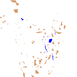
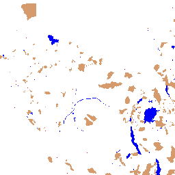
Spatial distribution of constraints (distribution_constraints_africa)
Areas unavailable for inland fish farming development including protected areas (i.e. areas of conservation, wildlife reserves and forests), large inland water bodies and major cities. Delineation of protected areas in digital format (vector) was available from the World Conservation Monitoring Centre (WCMC). Water bodies (perennial lakes and rivers) were derived from the Digital Chart of the World (DCW) from ESRI (1992) at 1 million scale and locations of major cities were provided by ArcWorld at 1:3000,000 scale.
There are currently no notifications for the service, click the feed icon to subscribe.