Food and Agriculture Organization (FAO) |
|
FAO GeoNetwork OGC Web Map Server

| Service health Now: |
|---|
- Interface
- Web Service, OGC Web Map Service 1.1.1
- Keywords
- FAO, WMS, OGC, GeoNetwork
- Fees
- none
- Access constraints
- none
- Data provider
-
Food and Agriculture Organization (FAO) (unverified)
Contact information:
Jeroen Ticheler
Food and Agriculture Organization (FAO)
postal:
Viale delle Terme di Caracalla, 00153 Rome, ItalyEmail:
Phone: +39-06 57051
Ads by Google
Available map layers (2)
FAO GeoNetwork OGC Web Map Server (GNW)
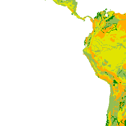
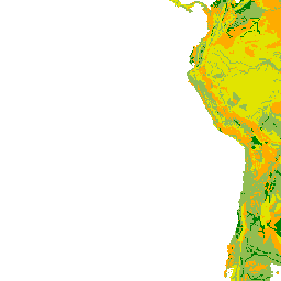
Soil and terrain suitability for ponds (soil_terrain_suitability_for_ponds)
Suitable areas for the construction of fish ponds based on the suitability of soils characteristics. FAO's Digital Soil Map of the World (DSMW) was used to derive the soil and terrain suitability for fish ponds.
There are currently no notifications for the service, click the feed icon to subscribe.