British Geological Survey |
|
GBR BGS British Geological Survey (BGS) offshore marine products
https://map.bgs.ac.uk/arcgis/services/Offshore/Products_WMS/MapServer/WmsServer

| Service health Now: |
|---|
- Interface
- Web Service, OGC Web Map Service 1.3.0
- Keywords
- Maps, Geology, United Kingdom, Continental shelf, Marine, Data, Spatial, Offshore, Sea-bed, Sediment, Hard substrate, OneGeology, MD_DATE@2022, MD_LANG@ENG
- Fees
- none
- Access constraints
- These data are delivered under the terms of the Open Government Licence (http://www.nationalarchives.gov.uk/doc/open-government-licence/), subject to the following acknowledgement accompanying the reproduced BGS materials: Contains British Geological Survey materials copyright NERC [year]. Contact us if you create something new and innovative that could benefit others usingbgsdata@bgs.ac.uk.
- Supported languages
- eng
- Data provider
-
British Geological Survey (unverified)
Contact information:
Garry Baker
British Geological Survey
postal:
British Geological Survey Environmental Science Centre, NG12 5GG Keyworth, UKEmail:
Phone: +44 (0)115 936 3100
- Service metadata
Ads by Google
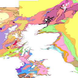
BGS offshore marine products are made available to view via this web map service. The 1:250 000 scale offshore geological maps in the UTM series (Universal Transverse Mercator projection) are available digitally as two themes: bedrock geology (DiGHardSubstrate250k) and sea-bed sediments (DigSBS250). Your use of any information provided by the BGS is at your own risk. BGS gives no warranty, condition or representation as to the quality, accuracy or completeness of the information or its suitability for any use or purpose. All implied conditions relating to the quality or suitability of the information, and all liabilities arising from the supply of the information (including any liability arising in negligence) are excluded to the fullest extent permitted by law.
Available map layers (5)
GBR BGS offshore marine products (BGS.offshore.marine.products)
BGS offshore marine products are made available to view via this web map service.
Offshore 1:250 000 scale marine bedrock polygons (BGS250k.Bedrock)
The BGS Offshore Bedrock 250k dataset is vector data which reflects the offshore bedrock geological of the UK and some of its adjacent waters at 1:250,000 scale. This comprehensive product provides a digital compilation of the paper maps published by BGS at the same scale, as well as, additional re-interpretations from regional geological studies. The composition, age and deformational history of the rocks underlying the seabed (bedrock) are important for a range of stakeholders, including marine spatial planners and offshore developers. The dataset is arranged in two GIS layers: Bedrock Lithostratigraphy and Bedrock Structural Geology. The polygons within the Bedrock Lithostratigraphy layer show the spatial distribution of the principal lithostratigraphical units (formations and groups). The lines within the Structural Geology layer show the location and extent of known structural features such as faults and folds. This broadscale dataset was derived from geophysical data (e.g. airgun, boomer, sparker, sidescan sonar, magnetometer, gravity meter) and data obtained from commercial wells and BGS shallow boreholes. The variations in data density will be reflected in the detail of the mapping.
GBR BGS Offshore 1:250 000 scale marine bedrock linear features (BGS250k.LinearBedrock)
The BGS Offshore Bedrock 250k dataset is vector data which reflects the offshore bedrock geological of the UK and some of its adjacent waters at 1:250,000 scale. This comprehensive product provides a digital compilation of the paper maps published by BGS at the same scale, as well as, additional re-interpretations from regional geological studies. The composition, age and deformational history of the rocks underlying the seabed (bedrock) are important for a range of stakeholders, including marine spatial planners and offshore developers. The dataset is arranged in two GIS layers: Bedrock Lithostratigraphy and Bedrock Structural Geology. The polygons within the Bedrock Lithostratigraphy layer show the spatial distribution of the principal lithostratigraphical units (formations and groups). The lines within the Structural Geology layer show the location and extent of known structural features such as faults and folds. This broadscale dataset was derived from geophysical data (e.g. airgun, boomer, sparker, sidescan sonar, magnetometer, gravity meter) and data obtained from commercial wells and BGS shallow boreholes. The variations in data density will be reflected in the detail of the mapping.
GBR BGS Offshore 1:250 000 scale sea bed sediment (BGS250k.SBS)
The BGS Seabed Sediments 250k dataset is vector data is vector data which reflects the distribution of seabed substrate types of the UK and some of its adjacent waters at 1:250,000 scale. This comprehensive product provides a digital compilation of the paper maps published by BGS at the same scale, as well as, additional re-interpretations from regional geological studies. The seabed is commonly covered by sediments that form a veneer or thicker superficial layer of unconsolidated material above the bedrock. These sediments are classified based on their grain size reflecting the environment in which were deposited. This information is important to a range of stakeholders, including marine habitat mappers, marine spatial planners, offshore industries (in particular, the dredging and aggregate industries). This dataset was primarily based on seabed grab samples of the top 0.1 m, combined with cores, dredge samples and sidescan sonar acquired during mapping surveys since the early 1970s. The variations in data density will be reflected in the detail of the mapping.
GBR BGS Offshore 1:250 000 scale hard substrate (BGS250k.HardSubstrate)
The Marine Hard Substrate dataset maps areas of rock or hard substrate outcropping or within 0.5m of the sea-bed. The interpretation was based on a variety of data sourced from within the British Geological Survey and externally. Data consulted includes archive sample and seismic records, side scan sonar, multibeam bathymetry and Olex datasets. The distribution of hard substrate at the seabed, or within 0.5 m is important in dictating the benthic assemblages found in certain areas. Therefore, an understanding of the distribution of these substrates is of primary importance in marine planning and designation of Marine Conservation Zones (MCZs) under the Marine and Coastal Access Act, 2009. In addition, a number of other users will value these data, including marine renewable companies, aggregate companies, the fishing and oil and gas industries. In order to address this issue it was necessary to update British Geological Survey sea-bed mapping to delineate areas where rock, boulders or cobbles are present at, or within 0.5m of the sea-bed surface. A polygon shape file showing areas of rock or hard substrate at, or within 0.5m of the sea-bed has been developed. The dataset has been created as vector polygons and are available in a range of GIS formats, including ArcGIS (.shp), ArcInfo Coverages and MapInfo (.tab). More specialised formats may be available but may incur additional processing costs.
There are currently no notifications for the service, click the feed icon to subscribe.