Thüringer Ministerium für Infrastruktu… |
|
| Service health Now: |
|---|
- Interface
- Web Service, OGC Web Map Service 1.3.0
- Keywords
- WMS_TH_DTK100_farbe, opendata, open data, Geobasisdaten, Geoproxy, TH, GDI TH, Freistaat Thüringen, Thüringer Landesamt für Bodenmanagement und Geoinformation, AdV, AdV-OWS-Basisprofil 1.0, AdV-WMS-Profil 4.0.0, WMS, Darstellungsdienst, Datengrundlage DTK, Digitale Topographische Karte 1:100 000, DTK100, DTK100 - Kombination farbig - th_dtk100, DTK100 - Metainformation - th_dtk100_info, Karte, ATKIS, Amtliches Topographisch-Kartographisches Informationssystem, view service, humanGeographicViewer, WMS
- Fees
- Dieses Angebot kann ab 2017-01-01 gemäß der "Datenlizenz Deutschland Namensnennung 2.0" (https://www.govdata.de/dl-de/by-2-0) genutzt werden. { "id": "dl-de-by-2.0", "name": "Datenlizenz Deutschland Namensnennung 2.0", "url": "https://www.govdata.de/dl-de/by-2-0 ", "quelle": "© GDI-Th" }
- Access constraints
- NONE. Es gelten keine Beschränkungen.
- Supported languages
- ger
- Data provider
-
Thüringer Ministerium für Infrastruktur und Landwirtschaft (unverified)
Contact information:
Kompetenzzentrum Geodateninfrastruktur Thüringen
Thüringer Ministerium für Infrastruktur und Landwirtschaft
postal:
Hohenwindenstr. 13 a, 99086 Erfurt, GermanyEmail:
Phone: +49 361 57-4176926
- Service metadata
Ads by Google
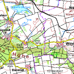
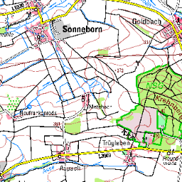
Dieser Web Map Service transportiert Rasterbilder der Digitalen Topographischen Karte 1:100 000 (DTK100) entsprechend dem AdV-Produktblatt (www.adv-online.de) in der Ausprägung farbe. Geoproxy Thüringen WMS DTK100 - Digitale Topographische Karte 1:100 000 Kombination farbig. Die Topographischen Karten liegen neben der farbigen Kombination ebenfalls in Einzelebenen vor und können über einen einen separaten WMS genutzt werden. Für kartenblattbezogene Informationen, die derzeit nicht über das GeoMIS.Thüringen aufgerufen werden können, wird pro Kartenwerk der digital geführten Topographischen Karte ein zusätzlicher Layer mit Metainformationen bereitgestellt, der z.B. Daten zur Aktualität des ausgewählten Kartenblattes enthält.
Available map layers (1)
TH DTK100 farbe (th_dtk100)
Farbiges Rasterbild der Digitalen Topographischen Karte 1:100 000 (DTK100)
There are currently no notifications for the service, click the feed icon to subscribe.