Marine Geoscience Data System |
|
Global Multi-Resolution Topography (GMRT), Version 3.4
| Service health Now: |
|---|
- Interface
- Web Service, OGC Web Map Service 1.3.0
- Keywords
- Fees
- unknown
- Access constraints
- unknown
- Supported languages
- No INSPIRE Extended Capabilities (including service language support) given. See INSPIRE Technical Guidance - View Services for more information.
- Data provider
-
Marine Geoscience Data System (unverified)
Contact information:
Data Manager
Marine Geoscience Data System
Email:
- Service metadata
- No INSPIRE Extended Capabilities (including service metadata) given. See INSPIRE Technical Guidance - View Services for more information.
Ads by Google
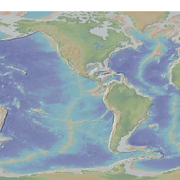
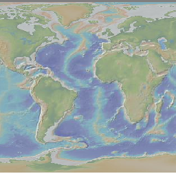
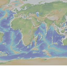
The Global Multi-Resolution Topography (GMRT) synthesis is a multi-resolution gridded compilation of edited multibeam sonar bathymetry data from the global and polar oceans, merged with terrestrial and lower resolution ocean data from GEBCO. Seafloor bathymetric data acquired with multibeam sonars are used for a wide range of fundamental research applications (e.g. on active seafloor geologic processes, bottom water circulation, biological habitats), as well as for more applied needs (e.g. marine resource management, tsunami inundation, submarine navigation). However these data have been acquired for only a small fraction of the oceans and typically require specialist knowledge to process. The GMRT is the only global-scale compilation of these data, providing access to grids and images to the full native resolution of the data, as well as attribution to the original data sources and is intended for broad use for research and education. The GMRT also serves the terrestrial community by providing easy access to images or grids from NASA’s ASTER terrestrial elevation data (30-m resolution) for the globe and the USGS National Elevation Dataset (NED) (10-m resolution) for portions of the US. New source swath sonar data are obtained from NOAA’s NGDC and other sources, and are evaluated, cleaned, edited, and then merged into the multi-resolution DEM. The GMRT synthesis is provided as a service of the IEDA:MGDS with funding from the U.S. National Science Foundation. Collaboration with Google has resulted in publication of the GMRT multibeam content in Google Earth. Further details on the architecture of the GMRT are available in Ryan et al. (2009) and from http://www.marine-geo.org/portals/gmrt/about.php.
Available map layers (13)
Global Multi-Resolution Topography (GMRT), Version 3.4 (GMRT)
The Global Multi-Resolution Topography (GMRT) synthesis is a multi-resolution gridded compilation of edited multibeam sonar bathymetry data from the global and polar oceans, merged with terrestrial and lower resolution ocean data from GEBCO. Seafloor bathymetric data acquired with multibeam sonars are used for a wide range of fundamental research applications (e.g. on active seafloor geologic processes, bottom water circulation, biological habitats), as well as for more applied needs (e.g. marine resource management, tsunami inundation, submarine navigation). However these data have been acquired for only a small fraction of the oceans and typically require specialist knowledge to process. The GMRT is the only global-scale compilation of these data, providing access to grids and images to the full native resolution of the data, as well as attribution to the original data sources and is intended for broad use for research and education. The GMRT also serves the terrestrial community by providing easy access to images or grids from NASA’s ASTER terrestrial elevation data (30-m resolution) for the globe and the USGS National Elevation Dataset (NED) (10-m resolution) for portions of the US. New source swath sonar data are obtained from NOAA’s NGDC and other sources, and are evaluated, cleaned, edited, and then merged into the multi-resolution DEM. The GMRT synthesis is provided as a service of the IEDA:MGDS with funding from the U.S. National Science Foundation. Collaboration with Google has resulted in publication of the GMRT multibeam content in Google Earth. Further details on the architecture of the GMRT are available in Ryan et al. (2009) and from http://www.marine-geo.org/portals/gmrt/about.php.
topo (topo)
topo
DEM-001 (DEM-001)
DEM-002 (DEM-002)
DEM-004 (DEM-004)
DEM-008 (DEM-008)
DEM-016 (DEM-016)
DEM-032 (DEM-032)
DEM-064 (DEM-064)
DEM-128 (DEM-128)
DEM-256 (DEM-256)
DEM-512 (DEM-512)
DEM-1024 (DEM-1024)
There are currently no notifications for the service, click the feed icon to subscribe.