Geological Survey of Finland |
|


| Service health Now: |
|---|
- Interface
- Web Service, OGC Web Map Service 1.3.0
- Keywords
- Sea bed sediment, Substrate, Sedimentation rate, Case study, Detailed surveys, Marine geological information, Baltic Sea, North Sea, Celtic Sea, Northern Europe, EuroGeoSurveys, OneGeology-Europe, Harmonised data
- Fees
- No Fees
- Access constraints
- Copyright: European Community represented by the European Commission. The holders of the intellectual property rights (IPR) to the data, which existed prior to the Contract being entered into, are the EMODNET-Geology partners. The EMODNET-Geology partners (the IPR holders) give no warranty, condition or representation as to the quality, accuracy or completeness of the data, information, or service, or its suitability for any use or purpose. All implied conditions relating to the quality or suitability of the information, and all liabilities arising from the supply of the information (including any liability arising in negligence) are excluded to the fullest extent permitted by law.
- Supported languages
- No INSPIRE Extended Capabilities (including service language support) given. See INSPIRE Technical Guidance - View Services for more information.
- Data provider
-
Geological Survey of Finland (unverified)
Contact information:
Aarno Kotilainen
Geological Survey of Finland
P.O. Box 96, FI-02151 Espoo Espoo, Finland
Email:
Phone: +3582055011
- Service metadata
- No INSPIRE Extended Capabilities (including service metadata) given. See INSPIRE Technical Guidance - View Services for more information.
Ads by Google
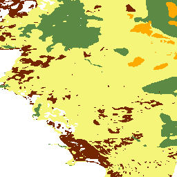
Sea-bed substrate map, sediment accumulation rate map and case studies of the EMODnet-Geology study area. The sea-bed substrate map of the Baltic Sea, the Greater North Sea and the Celtic Seas is presented at 1: 1 000 000 scale. The sea-bed substrate map is collated from more than 200 separate sea-bed substrate maps. The sediment accumulation rate map of the Baltic Sea and parts of the Greater North Sea shows point-source data from more than 600 sea-bed sediment sampling sites. Six case studies emphasize the importance of marine geological information, local features and detailed surveys in marine spatial planning and use of marine resources. The maps and case studies are collated and compiled within the EMODNET-Geology project.
Available map layers (3)
EMODNET substrate map (0)
Sea-bed substrate map of the Baltic Sea, the Greater North Sea and the Celtic Seas at 1: 1 000 000 scale. The map is collated and harmonised from substrate information within the EMODNET-Geology project. The current map is collated from more than 200 separate sea-bed substrate maps. Where necessary, the existing substrate classifications (of individual maps) have been translated to a scheme that is supported by EUNIS. This EMODNET reclassification scheme consists of four substrate classes defined on the basis of the modified Folk triangle (mud to sandy mud; sand to muddy sand; coarse sediment; mixed sediment) and two additional substrate classes (diamicton, rock). In addition, the mixed sediment includes four subcategories: mixed sediment with bimodal grain-size distribution; Glacial clay, Hard bottom complex and Highly patchy seafloor areas. This final version was produced in 28.6.2012.
EMODNET WP3 case studies (1)
Case studies of the EMODnet-Geology study area. Altogether six case studies were collated and compiled within the EMODNET-Geology project. Differences in the level of seafloor diversity and small features, which might have local importance, are not distinguished from the 1 M scale seabed substrate map. Case studies emphasize the importance of marine geological information, local features and detailed surveys in marine spatial planning and use of marine resources. Case studies are The importance of high resolution multibeam sonar data for conservation planning offshore Ireland: Carbonate mounds and cold-water coral habitats (Ireland); Heterogenic seafloor environment, generalization(Finland); Stony Reef of Slupsk Bank (Poland); Palaeo-Landscape of the Ustka test area (Poland); North-western Estonia(Estonia); and Revisiting the spatial distribution of EUNIS Level 3 North Sea habitats in view of Europe’s Marine Strategy Framework Directive(Belgium and Netherlands).
Sediment accumulation rates (2)
Sediment accumulation rate map of the Baltic Sea and parts of the Greater North Sea. The map is collated and compiled within the EMODNET-Geology project. The current map is collated from more than 600 seabed sediment sampling sites. Estimations of modern sediment accumulation rates (cm/year) are based mainly on the 137Cs that could be used as a timemarker in the sediment column. In the sediment column the activity peak of 137Cs corresponds to the fallout of the Chernobyl nuclear power plant accident of April 1986. Some accumulation rate estimations are based on the 210Pb dating, and some accumulation rates were estimated from acoustic-seismic and sediment core data. This version was produced in 25.6.2012.
There are currently no notifications for the service, click the feed icon to subscribe.