The Scottish Government, DG Enterprise… |
|
Scottish Government SDI and INSPIRE Services
| Service health Now: |
|---|
- Interface
- Web Service, OGC Web Map Service 1.3.0
- Keywords
- Fees
- none
- Access constraints
- none
- Supported languages
- No INSPIRE Extended Capabilities (including service language support) given. See INSPIRE Technical Guidance - View Services for more information.
- Data provider
-
The Scottish Government, DG Enterprise and Environment, Rural Payments & Inspections Directorate, IT & Business Support (unverified)
Contact information:
Spatial Data Management Team
The Scottish Government, DG Enterprise and Environment, Rural Payments & Inspections Directorate, IT & Business Support
mailing address:
Saughton House, Broomhouse Drive, EH11 3XD Edinburgh, United KingdomEmail:
Phone: 0131 244 1441
- Service metadata
- No INSPIRE Extended Capabilities (including service metadata) given. See INSPIRE Technical Guidance - View Services for more information.
Ads by Google
Scottish Government corporate datasets relevant to first phases of Scottish SDI and INSPIRE. One dataset per WMS layer. 1 Agricultural Area Offices 2 Agricultural Parishes 3 Cairngorm National Park boundaries 4 Community Health partnerships 5 Data Zone boundaries 6 Closed Areas (Marine Scotland) 7 Designated Bathing Waters 8 Environmentally Sensitive Areas 9 European Structural Fund Areas 2007 - 2013 10 Health Board boundaries 11 Intermediate Geography boundaries 12 Less Favoured Areas 13 Loch Lomond and the Trossachs national park boundaries 14 Marine Planning Zones 15 National Scenic Areas 16 Nitrate Vulnerable Zones 17 Salmon Fishery Districts 18 NUTS 2 19 NUTS 3 20 Scottish Government Urban Rural Classification 6 and 8 fold 21 Shellfish Growing Waters
Available map layers (22)
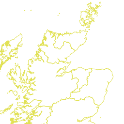
Scottish Government SDI and INSPIRE Services (SCOTLAND)
Scottish Government corporate datasets relevant to first phases of Scottish SDI and INSPIRE. One dataset per WMS layer. 1 Agricultural Area Offices 2 Agricultural Parishes 3 Cairngorm National Park boundaries 4 Community Health partnerships 5 Data Zone boundaries 6 Closed Areas (Marine Scotland) 7 Designated Bathing Waters 8 Environmentally Sensitive Areas 9 European Structural Fund Areas 2007 - 2013 10 Health Board boundaries 11 Intermediate Geography boundaries 12 Less Favoured Areas 13 Loch Lomond and the Trossachs national park boundaries 14 Marine Planning Zones 15 National Scenic Areas 16 Nitrate Vulnerable Zones 17 Salmon Fishery Districts 18 NUTS 2 19 NUTS 3 20 Scottish Government Urban Rural Classification 6 and 8 fold 21 Shellfish Growing Waters
Agricultural Area Office Boundaries (ag_area_offices)
16 Agricultural Area Offices provide local support for agricultural issues. This information then feeds into Agricultural Headquarters in Edinburgh.
Agricultural Parishes (agricultural_parishes)
Agricultural parishes are based on Civil Parishes which were abolished as an administrative unit in Scotland in 1975. Agricultural parishes continue to be used for boundary and statistical purposes. There are 891 agricultural parishes in Scotland and they are used in the Agricultural Census and for the payment of farming grants and subsidies. The dataset contains parish boundaries, parish names and parish codes.
Cairngorm National Park designated boundary (cairngorm_np_boundary)
The Cairngorm National Park was established in March 2003 under The Cairngorms National Park Designation, Transitional and Consequential Provisions (Scotland) Order 2003. The boundary was extended as part of the Cairngorms National Park Designation, Transitinal and Consequential Provisins (Scotland) Order 2003 Modification Order 2010. In the designation Order, the boundary is defined by the line on the deposited maps. This dataset represents that line. The aim of Scotland's National Parks is to deliver better management of areas of outstanding natural and cultural heritage. They aim to: conserve and enhance the natural and cultural heritage, promote the sustainable use of natural resources of the area, promote understanding and enjoyment (including enjoyment in the form of recreation) of the special qualities of the area by the public and promote sustainable social and economic development of the communities of the area.
Community Health Partnerships (community_health_partnerships)
The NHS Reform (Scotland) Act 2004 provides for the establishment of Community Health Partnerships (CHPs) across Scotland. The aims and expected outcomes of CHPs are outlined in Statutory Guidance. These new partnership arrangements will be at the heart of NHS and joint service planning and delivery with a key role in improving health and reducing inequalities, working in new ways with local communities and other statutory and voluntary sector providers. CHPs are co-terminous with Local Authority boundaries or sub divisions of boundaries and approved schemes describe the size of each CHP within the overall Local Authority boundary.
Data Zones 2001 (datazones)
Data zones are the core geography for dissemination of results from Scottish Neighbourhood Statistics (SNS). The data zone geography covers the whole of Scotland and nests within local authority boundaries. Data zones are groups of Census output areas which have populations of between 500 and 1,000 household residents, and some effort has been made to respect physical boundaries. In addition, they have compact shape and contain households with similar social characteristics. Data zones are a stable geography and can be used to analyse change over time. There are 6,505 data zones across Scotland, and each have been assigned an individual code that follows the Scottish Government's standard naming and coding convention. The code prefix is S01, which has been assigned to designate data zones. In some cases, data zones have also been assigned a name. To date, Local Authorities that have named their data zones include Eilean Siar (Western Isles), Fife, and Moray.
Closed Areas (closed_areas)
Marine and inshore areas closed to fisheries or exempt from closure and their timing, as defined by EC, EU and Scottish Statutory Instrument (SSI) regulatory legislation between 1997 and 2010. Legislation relates to the EU Common Fisheries Policy which is currently under review - http://www.scotland.gov.uk/Topics/marine/Sea-Fisheries/common-fisheries-policy. The areas relate to several marine species including Anchovy, Cockle, Cod, Haddock, Hake, Herring, Mackerel, Norway Pout, Plaice, Salmon, Sea Trout, Sandeel, Scallops, Sprat and Orange Roughy; and several fishing methods including Beam trawl, Bottom trawl, Creel, Dredging, Otter trawl, Gill nets and Towed nets. The areas extend west to North America (Newfoundland to Arctic Ocean) and east to Europe and Russia (Gibraltar to Barents Sea). Boundaries are based on ICES areas with ESRI coastlines to delineate land. Locations are held in latitude / longitude format and boundaries projected in WGS_1984. The dataset consists of closed and exempt (exception) area boundaries amalgamated in an ESRI shapefile (ClosedAreas.shp). Currently the dataset has 111 closed areas, some of which include exception areas, and which may be closed for varying periods through the year. Note that this dataset does not include boundaries for the voluntary system of Real Time Closures (RTCs) to protect North Sea cod stocks which has been in operation since September 2007 - http://www.scotland.gov.uk/Topics/marine/Sea-Fisheries/17681/closures Individual closed and exception boundaries also exist as separate shapefiles with their relevant legislation documents. The legislation is summarised in an Excel spreadsheet (LegislationDB.xls). Further details can be found in Data History.
Designated Bathing Waters (bathing_waters)
Beach areas designated under the Bathing Waters Directive (76/160/EEC) to protect the environment and public health at locations where bathing is not prohibited and is traditionally practised by a large number of bathers. The Directive requires that water quality at all designated bathing waters must meet specific microbiological requirements in order to protect the health of those that bathe there. The waters are designated on the basis of significant use, taking into account varying population densities and visitor numbers. There are 82 site designations contained in this dataset.The extents of the bathing waters 1st June 2010 as defined by the Scottish Government and SEPA as required by the Bathing Waters (Scotland) Direction 2010. All extents are based on results from intensive water sampling carried out by SEPA. The Dataset consists of beach polygons, and a 100m offshore buffer. Please note that not all bathing waters are to be coded in alphabetical order.
Environmentally Sensitive Areas (environmentally_sensitive_areas)
The Environmentally Sensitive Areas (ESA's) scheme was first introduced in 1987. The ESA scheme was introduced in Scotland to help conserve specially designated areas of the countryside where the landscape, wildlife or historic interest is of particular importance and where these environmental features can be affected by farming operations. ESA's were designated under powers given to the Secretary of State in the Agriculture Act 1986. In addition Parliament approved individual Statutory Instruments which set out the terms and conditions for each designated area. There are 10 ESA's currently operating in Scotland.
European Structural Fund Areas 2007-2013 (european_structural_fund_areas_2007_2013)
European Structural Fund Area 2007 - 2013 consists of 2 programme areas: Highland & Island Convergence Objective Programme areas and the Lowlands & Uplands Regional Competitiveness & Employment Objective programme area.
NHS Health Boards (NHS_boundaries)
Health care provision in Scotland is the responsibility of geographically-based local NHS Boards, which report to the Scottish Government. The boundaries of Health Boards were constituted by The National Health Service (Determination of Areas of Health Boards) (Scotland) Order 1974 (SI 1974/266), by reference to Region, District and Islands Area local authorities which were defined in the Local Government (Scotland) Act 1973. There has been one amendment to that Order since it was made (SSI 2006/33), to allow the abolition of Argyll & Clyde Health Board in 2006. Since Health Boards are based on groups of the Local Government Regions and Districts that existed before the introduction of Council Areas in 1996, there are cases where Health Boards cross Council boundaries. The areas affected by this are Ardoch, Moodiesburn, and Rutherglen (Greater Glasgow and Clyde, Highland, and Lanarkshire Health Boards). There are 14 NHS Health Boards across Scotland, and each have been assigned an individual code that follows the Scottish Government's standard naming and coding convention. The code prefix is S08, which has been assigned to designate Health Boards. For the presentation of statistics it is recommended that boards are listed in alphabetical order by Health Board name.
Intermediate Zones 2001 (intermediate_geographies)
Intermediate zones are a statistical geography that sit between data zones and local authorities, created for use with the Scottish Neighbourhood Statistics (SNS) programme. Intermediate zones are used for the dissemination of statistics that are not suitable for release at the data zone level because of the sensitive nature of the statistics, or for reasons of reliability. Intermediate Zones were designed to meet constraints on population thresholds (2,500 - 6,000 household residents), to nest within local authorities (as they were in 2001), and to be built up from data zones. The aim was also to build intermediate zones by grouping together data zones with similar social characteristics, to have fairly compact shape and to take into account physical boundaries. Intermediate zones are a stable geography and can be used to analyse change over time. There are 1,235 intermediate zones across Scotland, and each have been assigned an individual code that follows the Scottish Government's standard naming and coding convention. The code prefix is S02, which has been assigned to designate intermediate zones. In most cases, intermediate zones were also been assigned a name by the relevant Community Planning Partnership. From time to time Local Authorities may choose to update these names, and this dataset will be updated to reflect these changes.
Less Favoured Areas (less_favoured_areas)
In recognition of the different physical and socio-economic characteristics across the regions, the European Union introduced the Less Favoured Area (LFA) designation to support farming where production conditions are difficult. The criteria for LFA designation were first established in European legislation in 1975 (Directive 75/268 EEC and accompanying measures). There are 3 types of LFA's; all in Scotland fall into the category of simple LFA's marked by poor soils and low agricultural income. Scotland's LFA's are defined by: - The presence of poor land of poor productivity, which is difficult to cultivate and with a limited potential which cannot be increased except at excessive cost, and which is mainly suitable for extensive livestock farming. - lower than average production, compared to the main indices of economic performance in agriculture. - a low or dwindling population predominantly dependent on agricultural activity, the accelerated decline of which could cause rural depopulation.
Loch Lomond and The Trossachs National Park designated boundary (LL_and_T_NP_boundary)
The Loch Lomond and The Trossachs National Park was established in July 2002 under The Loch Lomond and The Trossachs National Park Designation, Transitional and Consequential Provisions (Scotland) Order 2002. In the designation Order, the boundary is defined by the line on the deposited map. This dataset represents that line. The aim of Scotland's National Parks is to deliver better management of areas of outstanding natural and cultural heritage. They aim to: conserve and enhance the natural and cultural heritage, promote the sustainable use of natural resources of the area, promote understanding and enjoyment (including enjoyment in the form of recreation) of the special qualities of the area by the public and promote sustainable social and economic development of the communities of the area.
Marine Planning Zones (marine_planning_zones)
Marine Planning Zones are defined in the Town and Country Planning (Marine Fish Farming) (Scotland) Order 2007. The Zones designate marine areas for which planning authorities discharge their functions with regard to fish farming developments.
National Scenic Areas (National_Scenic_Areas)
National Scenic Areas are Scotland's only national landscape designation. They are those areas of land considered of national significance on the basis of their outstanding scenic interest which must be conserved as part of the country's natural heritage. They have been selected for their characteristic features of scenery comprising a mixture of richly diverse landscapes including prominent landforms, coastline, sea and fresh water lochs, rivers, woodland and moorlands. NSA's were identified by the former Countryside Commission for Scotland and they are described in 'Scotland's Scenic Heritage', published in 1978. No new areas have been identified since then. Most areas are in private ownership although the Forestry Commission has some sizeable land holdings. There are 40 NSAs in Scotland covering 1 million hectares which is 12.7% of Scotland.
Nitrate Vulnerable Zones (nitrate_vulnerable_zones)
NVZ's are designated in accordance with the requirements of the European Commision's Nitrate Directive 91/676/EEC, which aims to reduce water pollution caused by nitrates from agricultural sources. Four areas of Scotland were designated as NVZs in 2002 -03 under the following regulations: The Designation of Nitrate Vulnerable Zones (Scotland) Regulations 2002 (SSI No.276) The Designation of Nitrate Vulnerable Zones (Scotland) (No.2) Regulations 2002 (SSI No.546.
Salmon Fishery Districts (salmon_fishery_districts)
For the purpose of salmon fishery management, Scotland is divided into 54 statutory salmon fishery districts. The districts comprise of the natural catchment areas of a specific river or group of rivers. There are currently District Salmon Fishery Boards (DSFBs) constituted for 42 of these districts. In recent years, progressive moves have been made to amalgamate smaller districts to create larger, more coherent single districts for the purpose of creating a single DSFB, and this process is still ongoing. Changes are made through the SSI process. District Salmon Fishery Boards History - Although DSFBs have their origin in the salmon fisheries acts introduced in the mid 1800s, their constitution was changed in 1986 and was provided in the 1986 Salmon Act [now consolidated into the Salmon & Freshwater Fisheries (Consolidation) (Scotland) Act 2003]. Salmon fisheries in Scotland are privately owned. Elected representatives of those owners provide the core of the membership of a Board. However, since 1986, the boards are required also to include representatives of salmon anglers and salmon netsmen in the district. The Government made a further revision to the constitution of the Boards in 1999 to allow for even wider representation on the boards by bodies like SEPA and SNH or others, such as local angling clubs and associations.
Nomenclature of Units for Territorial Statistics (NUTS) - Level 2 (nuts2)
The nomenclature of territorial units for statistics, abbreviated as NUTS (from the French 'Nomenclature des Unités territoriales statistiques') is a geographical classification that subdivides territories of the European Union (EU) into regions at three different levels (NUTS 1, 2 and 3, respectively, moving from larger to smaller territorial units). At the local scale, two levels of Local Administrative Units (LAU) are also defined: LAU 1 and LAU 2 (formerly referred to as NUTS 4 and NUTS 5, respectively). NUTS areas aim to provide a single and coherent territorial breakdown for the collection, development, and harmonisation of EU regional statistics. Further, eligibility for aid from European Structural Funds (for those regions whose development is lagging behind) is assessed at NUTS 2 level. The NUTS classification was originally developed by Eurostat in the early 1970's, however, only gained legal status with Regulation (EC) No 1059/2003 which entered into force in July 2003. A first regular amendment ((EC) No 105/2007) replaced the 2003 version of NUTS with the 2006 version, enacted on 1 January 2008. The current classification is valid until December 31, 2011. For Scottish NUTS areas, the NUTS 1 region covers the whole of Scotland, whereas NUTS 2 subdivides Scotland into 4 regions, and NUTS 3 to 23 regions. Above NUTS 1 is the 'national' level of the EU Member State - the United Kingdom. For Local Administrative Units (LAU) there are currently 41 units at LAU level 1 and 1,222 at level 2. Codes for NUTS regions are prefixed by the characters 'UKM', where 'UK' identifies the member state, the United Kingdom, and 'M' indicates Scotland.
Nomenclature of Units for Territorial Statistics (NUTS) - Level 3 (nuts3)
The nomenclature of territorial units for statistics, abbreviated as NUTS (from the French 'Nomenclature des Unités territoriales statistiques') is a geographical classification that subdivides territories of the European Union (EU) into regions at three different levels (NUTS 1, 2 and 3, respectively, moving from larger to smaller territorial units). At the local scale, two levels of Local Administrative Units (LAU) are also defined: LAU 1 and LAU 2 (formerly referred to as NUTS 4 and NUTS 5, respectively). NUTS areas aim to provide a single and coherent territorial breakdown for the collection, development, and harmonisation of EU regional statistics. Further, eligibility for aid from European Structural Funds (for those regions whose development is lagging behind) is assessed at NUTS 2 level. The NUTS classification was originally developed by Eurostat in the early 1970's, however, only gained legal status with Regulation (EC) No 1059/2003 which entered into force in July 2003. A first regular amendment ((EC) No 105/2007) replaced the 2003 version of NUTS with the 2006 version, enacted on 1 January 2008. The current classification is valid until December 31, 2011. For Scottish NUTS areas, the NUTS 1 region covers the whole of Scotland, whereas NUTS 2 subdivides Scotland into 4 regions, and NUTS 3 to 23 regions. Above NUTS 1 is the 'national' level of the EU Member State - the United Kingdom. For Local Administrative Units (LAU) there are currently 41 units at LAU level 1 and 1,222 at level 2. Codes for NUTS regions are prefixed by the characters 'UKM', where 'UK' identifies the member state, the United Kingdom, and 'M' indicates Scotland.
Scottish Government Urban Rural Classification 6 and 8 fold (sgur_2009_2010_hwm)
The Scottish Government (SG) Urban/Rural Classification provides a consistent way of defining urban and rural areas across Scotland. The classification is based upon two main criteria: (i) population as defined by the General Register Office for Scotland (GROS), and (ii) accessibility based on drive time analysis to differentiate between accessible and remote areas in Scotland. The classification is available in two forms, a 6-fold classification which distinguishes between urban, rural, and remote areas through six categories, and an 8-fold classification which further distinguishes between remote and very remote regions. The population criteria is derived from the Settlements dataset produced by GROS, which defines areas of contiguous high population density postcodes that make up a Settlement. Using the population thresholds of 125,000, 10,000 and 3,000 people, Settlements can be grouped into the following categories: (1) Large Urban Areas - population greater than 125,000 (2) Other Urban Areas - populations between 10,000 and 125,000 (3) Small Towns - populations between 3,000 and 10,000 (4) Rural Areas - populations less than 3,000 Accessibility is measured in terms of drive times to an urban area. This was done by calculating a 30 minute drive time from the population weighted centroid of Settlements with a population of 10,000 or more (i.e. Large and Other Urban Areas). For the 8-fold Urban/Rural Classification, an additional 60 minute drive time was also calculated. The drive time analysis was performed using specialist GIS software (ESRI ArcGIS, ProTerritory extension). Results of the analysis allowed for areas to be classified in terms of accessibility by the following categories: (1) Accessible - Areas within a 30 minute drive time of a Settlement with a population of 10,000 or more. (2) Remote - Areas that are more than a 30 minute drive time (6-fold classification), or areas that have a drive time between 30 and 60 minutes (8-fold classification) from a Settlement with a population of 10,000 or more. (3) Very Remote - Areas that are more than a 60 minute drive time from a Settlement with a population of 10,000 or more (8-fold classification only). Combining both the population and accessibility measures, a Scotland-wide Urban/Rural Classification is defined. The 6-fold classification distinguishes between urban, rural and remote areas by the following categories: (1) Large Urban Areas - Settlements of over 125,000 people. (2) Other Urban Areas - Settlements of 10,000 to 125,000 people. (3) Accessible Small Towns - Settlements of between 3,000 and 10,000 people, and within a 30 minute drive time of a Settlement of 10,000 or more. (4) Remote Small Towns - Settlements of between 3,000 and 10,000 people, and with a drive time of over 30 minutes to a Settlement of 10,000 or more. (5) Accessible Rural Areas - Areas with a population of less than 3,000 people, and within a 30 minute drive time of a Settlement of 10,000 or more. (6) Remote Rural Areas - Areas with a population of less than 3,000 people, and with a drive time of over 30 minutes to a Settlement of 10,000 or more. An 8-fold classification is also defined, which distinguishes between Remote and Very Remote areas by the addition of a 60 minute drive time threshold. The categories for the 8-fold classification are as follows: (1) Large Urban Areas - Settlements of over 125,000 people. (2) Other Urban Areas - Settlements of 10,000 to 125,000 people. (3) Accessible Small Towns - Settlements of between 3,000 and 10,000 people, and within a 30 minute drive time of a Settlement of 10,000 or more. (4) Remote Small Towns - Settlements of between 3,000 and 10,000 people, and with a drive time between 30 and 60 minutes to a Settlement of 10,000 or more. (5) Very Remote Small Towns - Settlements of between 3,000 and 10,000 people, and with a drive time of over 60 minutes to a Settlement of 10,000 or more. (6) Accessible Rural Areas - Areas with a population of less than 3,000 people, and within a drive time of 30 minutes to a Settlement of 10,000 or more. (7) Remote Rural Areas - Areas with a population of less than 3,000 people, and with a drive time of between 30 and 60 minutes to a Settlement of 10,000 or more. (8) Very Remote Rural Areas - Areas with a population of less than 3,000 people, and with a drive time of over 60 minutes to a Settlement of 10,000 or more. The Scottish Government Urban/Rural Classification is normally updated on a biennial basis, with the boundaries represented in this particular dataset reflective of the years 2009 to 2010.
Shellfish Growing Waters (shellfish_waters)
Designated areas under Article 4 of Directive on Quality of Shellfish Waters 79/923/EEC. The areas have been digitised using the descriptions in the Schedule. Growing Waters may or may not coincide with production/hygiene areas. There are currently 108 designated shellfish waters in Scotland. Twenty two were originally designated in 1998, further amendments were made in 2000, 2002 and 2006. Further amendments - dedesignations were made where it was proven there was no cultivaton within 35 sites, therefore these sites did not require monitoring under the Shellfish Waters Directive.
There are currently no notifications for the service, click the feed icon to subscribe.