[unknown data provider] |
|
| Service health Now: |
|---|
- Interface
- Web Service, OGC Web Map Service 1.3.0
- Keywords
- Land Tenure, Inuvialuit Lands, Settlement lands, Aboriginal lands
- Fees
- unknown
- Access constraints
- unknown
- Supported languages
- No INSPIRE Extended Capabilities (including service language support) given. See INSPIRE Technical Guidance - View Services for more information.
- Data provider
-
unknown (unverified)
Contact information:
- Service metadata
- No INSPIRE Extended Capabilities (including service metadata) given. See INSPIRE Technical Guidance - View Services for more information.
Provide a national coverage and promote the use of a common geometric representation for Aboriginal Lands in Canada. This data set is not to be used for defining boundaries. Administrative decisions should be based on legal documents and legal survey plans.
Available map layers (3)
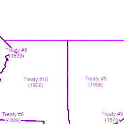
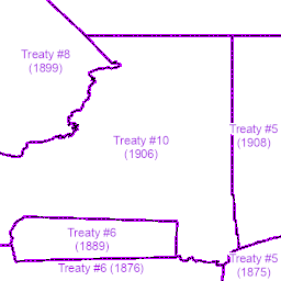
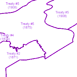
First Nation Treaty Boundaries (0)
Data Requested from AANDC;SK specifically interested in the treaty territories which fall within and/or overlap the SK border. Treaties 2,4,5,6,7,8,10 http://sidait-atris.aadnc-aandc.gc.ca/atris_online/home-accueil.aspx
Indian Reserve (ISC) (1)
The distributed INDIAN_RESERVE feature layer, part of the ISC SaskGIS Cadastral dataset, contains a copy of the INDIAN RESERVE feature layer taken from Information Services Corporation (ISC) of Saskatchewans geospatial database. The data is comprised of geospatial locations and attributional information for all indian reserve parcels that reside within the province of Saskatchewan. The feature layer identifies each indian reserve parcel by indian reserve name, indian reserve number, PPID (unique ID), indian reserve band name, indian reserve band number and geospatial location. The indian reserve parcels have been derived from legal survey data and control survey points. This data is suitable for use in Geographic Information Systems (GIS) and Computer Aided Drawing Systems (CAD). This data is available live and current at www.geosask.ca, and is also available via monthly deliveries for ISCs commercial users. The data that is delivered monthly undergoes rigorous quality control cycles and can be packaged as whole data and/or as change records (which indicate entities that have been added, deleted and modified since the previous months delivery).
Indian Reserve (NRCan) (2)
The Aboriginal Lands product consists of polygon entities that depict the administrative boundaries (extent) of lands where the title has been vested in specific Aboriginal Groups of Canada or lands which were set aside for their exclusive benefit. The dataset represents those lands recognized as First Nations reserves by the Government of Canada.( data is updated monthly)