Gouvernement du Canada; Ressources nat… |
|
Unmanned Aerial Vehicle Survey (UAV) - Cambridge Bay (Nunavut)
| Service health Now: |
|---|
- Interface
- Web Service, OGC Web Map Service 1.3.0
- Keywords
- Remote sensing,Cartography,Geographic data,Geomatics,UAV,unmanned aerial vehicle,orthorectified,mosaic,northern,vegetation
- Fees
- unknown
- Access constraints
- Licence du gouvernement ouvert - Canada (http://ouvert.canada.ca/fr/licence-du-gouvernement-ouvert-canada)
- Supported languages
- No INSPIRE Extended Capabilities (including service language support) given. See INSPIRE Technical Guidance - View Services for more information.
- Data provider
-
Gouvernement du Canada; Ressources naturelles Canada (unverified)
Contact information:
Gouvernement du Canada; Ressources naturelles Canada
Email:
Phone: 1 (800) 661 2638
- Service metadata
- No INSPIRE Extended Capabilities (including service metadata) given. See INSPIRE Technical Guidance - View Services for more information.
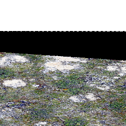
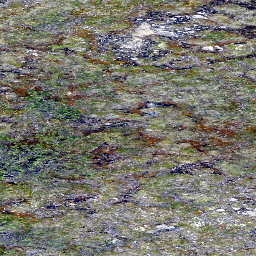
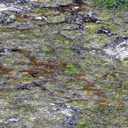
Data was created or derived from unmanned aerial vehicle (UAV) imagery acquired from a single day survey, July 28th 2016, in Cambridge Bay, Nunavut. Five control points taken from a Global Differential Positioning System were positioned in the corners and the center of the vegetation survey. The following datasets covers 525m2 and was produced by Canada Centre for Remote Sensing /Canada Centre for Mapping and Earth Observation: - UAV Digital Surface Model (DSM) in Cambridge Bay, Nunavut -Vegetation Plot - UAV Orthomosaic of Cambridge Bay, Nunavut - Vegetation Plot - UAV Vegetation Height Model, Cambridge Bay, Nunavut The UAV survey was completed in collaboration with the Canadian High Arctic Research Station (CHARS) for northern vegetation monitoring research. For more information, refer to our current Arctic vegetation research: Fraser et al; ""UAV photogrammetry for mapping vegetation in the low-Arctic"" Arctic Science, 2016, 2(3): 79-102, 10.1139/as-2016-0008 http://www.nrcresearchpress.com/doi/abs/10.1139/AS-2016-0008
Available map layers (3)
UAV Orthomosaic - 0.34 cm / Vegetation Plot - Cambridge Bay (Nunavut) (0)
The 1 cm resolution digital surface model (DSM) was created from unmanned aerial vehicle (UAV) imagery acquired from a single day survey, July 28th 2016, in Cambridge Bay, Nunavut. Five control points taken from a Global Differential Positioning System were positioned in the corners and the center of the vegetation survey. The DSM covering 525m2 was produced by Canada Centre for Remote Sensing /Canada Centre for Mapping and Earth Observation. The UAV survey was completed in collaboration with the Canadian High Arctic Research Station (CHARS) for northern vegetation monitoring research.
UAV Digital Surface Model - 1 cm / Vegetation Plot - Cambridge Bay (Nunavut) (1)
The 1 cm resolution digital surface model (DSM) was created from unmanned aerial vehicle (UAV) imagery acquired from a single day survey, July 28th 2016, in Cambridge Bay, Nunavut. Five control points taken from a Global Differential Positioning System were positioned in the corners and the center of the vegetation survey. The DSM covering 525m2 was produced by Canada Centre for Remote Sensing /Canada Centre for Mapping and Earth Observation. The UAV survey was completed in collaboration with the Canadian High Arctic Research Station (CHARS) for northern vegetation monitoring research.
UAV Vegetation Height Model - 1 cm - Cambridge Bay (Nunavut) (2)
The 1 cm resolution vegetation digital height model was extracted using a bare earth model and digital surface model (DSM) derived from unmanned aerial vehicle (UAV) imagery acquired from a single day survey on July 28th 2016, in Cambridge Bay, Nunavut. the mapping product cover 525m2 and was produced by Canada Centre for Remote Sensing /Canada Centre for Mapping and Earth Observation. The UAV survey was completed in collaboration with the Canadian High Arctic Research Station (CHARS) for northern vegetation monitoring research.