i-cubed |
|
BG Group Service


| Service health Now: |
|---|
- Interface
- Web Service, OGC Web Map Service 1.1.1
- Keywords
- Fees
- unknown
- Access constraints
- unknown
- Data provider
-
i-cubed (unverified)
Contact information:
Support
i-cubed
mailing and physical:
1600 Prospect Park Way, 80525 Fort Collins, USAEmail:
Phone: 1-970-482-4400
Ads by Google
BG Group Service
Available map layers (16)
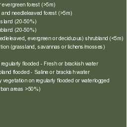
Global:Imagery:ESA Land Cover Legend (33a5505d-2d42-4b7d-92c3-4b9a91384625)
Global:Imagery:ESA Land Cover Legend
Global:Imagery:LandSat Metadata (f46b3f78-cfaa-4c60-aa96-b3863fdc7ae2)
Global:Imagery:LandSat GeoCover Collection reprocessed by i3. Metadata Max Display set at 11,000,000.
Global: Imagery: ESRI World Imagery (b21d2703-2292-4bb7-85aa-08b9c473ff95)
This map presents low-resolution imagery for the world and high-resolution imagery for the United States and other areas around the world. Source: www.Esri.com
Partial:Imagery:BingBirds Eye-West (068f2861-5a26-4f05-a105-5d88bcd5eaa3)
Foundation Dataset. Bing Maps aerial imagery (30cm) viewed from east to west with an oblique perspective. This data only covers a select few locations where Bing has made this available. Must zoom to 1:2,500 for imagery to display
Partial:Imagery:Bing BirdsEye-South (7e8562b3-c11e-43b1-9fb0-92e8cdacb053)
Foundation Dataset. Bing Maps aerial imagery (30cm) viewed from north to south with an oblique perspective. This data only covers a select few locations where Bing has made this available. Must zoom to 1:2,500 for imagery to display
Partial:Imagery:Bing BirdsEye-North (a14176a6-1eb1-4738-84fe-b0bc2b11274c)
Foundation Dataset. Bing Maps aerial imagery (30cm) viewed from south to north with an oblique perspective. This data only covers a select few locations where Bing has made this available. Must zoom to 1:2,500 for imagery to display
Partial:Imagery:Bing BirdsEye-East (f37e04cc-5a96-487e-9e30-38548996ace7)
Foundation Dataset. Bing Maps aerial imagery (30cm) viewed from west to east with an oblique perspective. This data only covers a select few locations where Bing has made this available. Must zoom to 1:2,500 for imagery to display
Global:Imagery:Bing Maps with Vintage (bd8f0d91-a9ce-4734-ac1b-6df41a61220b)
Foundation Dataset. Worldwide Bing Maps imagery data, with vintage metadata overlay, same imagery as available on Bing Maps web application.
Global:Imagery:Bing Maps (6c8e2750-3178-4be7-a615-03fe628488de)
Foundation Dataset. Bing Maps 30cm+ imagery, same as available on Bing Maps web applications, covering the globe.
US:Imagery:eDOQQ Historic (2e6de450-e5f5-4f35-a9ef-5bec1d1635a4)
Foundation Dataset. Seamless USGS Digital Orthophoto Quadrangle - panchromatic aerial photography, covers US lower 48 states, parts of Alaska, Hawaii, and Puerto Rico. Source: www.usgs.gov
US:Imagery:NLCD-Land Cover (787d3d75-7af2-4a5f-ad26-216cd22e4b4a)
Foundation Dataset. 2006 version of the USGS National Land Cover Database thematic representation of Land Cover, for the conterminous US. Source: landcover.usgs.gov
Global:Imagery:ESA Land Cover (4e044d65-dd98-4610-a34d-038320efd940)
Foundation Dataset. European Space Agency - ESA, Ionia GlobCover, 300m resolution land cover data, covering the globe. Source: due.esrin.esa.int
Global:Imagery:Corine Land Cover (88d6f186-b332-480a-8191-e99489879ec0)
Foundation Dataset: European Environmental Agency - EEA, Corine Landcover: an inventory of land cover in 44 classes, and presented as a cartographic product, at a scale of 1:100 000. Corine is a 100m land cover land use map encompassing most of the countries of Europe compiling layers from 1990, 2000 and 2006. Source: eea.europa.eu
Global:Imagery:LandSat 7,4,2 (1d50f0be-8d1e-4acf-ac00-0b09c2606bca)
Foundation Dataset. Global, seamless 15m resolution Landsat imagery presented using the 7, 4 and 2 band combination. Source: landsat.gsfc.nasa.gov
Global:Imagery:LandSat NC (b27fb27a-d92a-4a07-b8d0-dc1844ebd1da)
Foundation Dataset. Seamless 15m resolution Landsat Natural Color imagery, covering most of the globe. Source: landsat.gsfc.nasa.gov
Global:Imagery:Spatial Energy Base (90d56faa-8371-476b-83ed-c1a293b54e98)
Foundation Dataset. Spatial Energy's Global Imagery Basemap. This is a combination of US NAIP 1m, MODIS 30m, and LandSat 15m imagery covering the entire globe.
There are currently no notifications for the service, click the feed icon to subscribe.