[unknown data provider] |
|

| Service health Now: |
|---|
- Interface
- Web Service, OGC Web Map Service 1.3.0
- Keywords
- Fees
- unknown
- Access constraints
- unknown
- Supported languages
- No INSPIRE Extended Capabilities (including service language support) given. See INSPIRE Technical Guidance - View Services for more information.
- Data provider
-
unknown (unverified)
Contact information:
- Service metadata
- No INSPIRE Extended Capabilities (including service metadata) given. See INSPIRE Technical Guidance - View Services for more information.
Ads by Google
WMS
Available map layers (1)
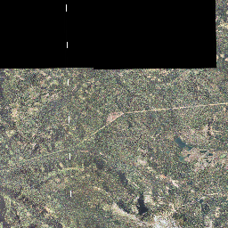
Imagery_Mosaic2005 (0)
This map service presents 1/2 meter, 4-band ortho imagery for the state of Oregon acquired in 2005. Data is projected using the Oregon projection standard, Oregon Lambert Intl Feet. Thanks to the U.S. Department of Agriculture’s National Agriculture Imagery Program (NAIP) and a multi-agency partnership coordinated by the Oregon Geospatial Enterprise Office, high resolution color aerial photography is available of the entire state. The Imagery Framework is helping realize the vision of navigatOR with state-of-the-art accessibility to common data themes that geographic data users need. Older imagery, as well as future acquisitions, will also be available here. Please see additional statewide imagery products, as well as image downloads and information on how to connect to the 2005 imagery through a WMS service in ArcMap, please see the Oregon Imagery Explorer page. This service is provided by the State of Oregon Geospatial Enterprise Office.
There are currently no notifications for the service, click the feed icon to subscribe.