EEA |
|
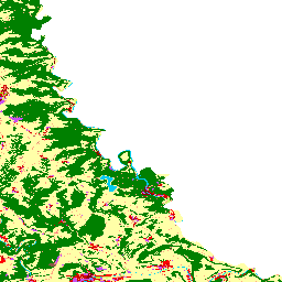
Urban Atlas 2011
http://discomap.eea.europa.eu/arcgis/services/Land/UrbanAtlas_Dyna_LAEA/MapServer/WmsServer

| Service health Now: |
|---|
- Interface
- Web Service, OGC Web Map Service 1.3.0
- Keywords
- ["Urban Area","Atlas","Landuse"]
- Fees
- unknown
- Access constraints
- unknown
- Supported languages
- No INSPIRE Extended Capabilities (including service language support) given. See INSPIRE Technical Guidance - View Services for more information.
- Data provider
-
EEA (unverified)
Contact information:
EEA
- Service metadata
- No INSPIRE Extended Capabilities (including service metadata) given. See INSPIRE Technical Guidance - View Services for more information.
Ads by Google
The Urban Atlas is part of the implementation of the Global Monitoring of Environment and Security (GMES) service. Compiled from thousands of satellite photographs, the Urban Atlas provides detailed and cost-effective digital mapping. The Urban Atlas will enable urban planners and the public to assess risks and opportunities, ranging from threat of flooding and impact of climate change, and to identifying new infrastructure needs. All cities in the EU will be covered by the Urban Atlas by 2011. This map will provide for the first time homogeneous and up-to-date information on urban environments, allowing for a comparison of different cities all across Europe. Data source: http://www.eea.europa.eu/data-and-maps/data/urban-atlas
Available map layers (3)
European Cities Landuse (1)
FUA_2012_for_2006_cities_LAEA (2)
Nomenclature of Units for Territorial Statistics, Level 3 (3)
There are currently no notifications for the service, click the feed icon to subscribe.