British Oceanographic Data Centre (BODC) |
|
WMS - GEBCO Grid North Polar View
https://www.gebco.net/data_and_products/gebco_web_services/north_polar_view_wms/mapserv
| Service health Now: |
|---|
- Interface
- Web Service, OGC Web Map Service 1.3.0
- Keywords
- Bathymetry, Grid, GEBCO, polar
- Fees
- unknown
- Access constraints
- Imagery from this WMS is not to be used for navigation or any purpose relating to safety at sea. Although every effort has been made to make sure that the imagery is as error free as possible, the British Oceanographic Data Centre (BODC) and General Bathymetric Chart of the Oceans (GEBCO) give no warranty as to the quality or completeness of the imagery or to the non-interruption or continuation of the service.
- Supported languages
- No INSPIRE Extended Capabilities (including service language support) given. See INSPIRE Technical Guidance - View Services for more information.
- Data provider
-
British Oceanographic Data Centre (BODC) (unverified)
Contact information:
Pauline Weatherall
British Oceanographic Data Centre (BODC)
Postal:
Joseph Proudman Building, 6 Brownlow Street, L3 5DA Liverpool, UKPhone: +44 (0)151 795 4800
- Service metadata
- No INSPIRE Extended Capabilities (including service metadata) given. See INSPIRE Technical Guidance - View Services for more information.
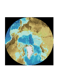
The General Bathymetric Chart of the Oceans (GEBCO) consists of an international group of experts who work on the development of a range of bathymetric data sets and products. GEBCO operates under the joint auspices of the International Hydrographic Organization (IHO) and the Intergovernmental Oceanographic Commission (IOC) of UNESCO. See our web site for more information about GEBCO at www.gebco.net. This WMS provides access to the GEBCO_2014 Grid, in the form of shaded relief imagery as layer 'GEBCO_NORTH_POLAR_VIEW' in a polar stereographic projection for the region north of 50N. The GEBCO_2014 Grid is a global grid of elevation data at 30 arc-second intervals. Please note that this data set has now been superseded by a later GEBCO grid. Please visit GEBCO's web site for further details: www.gebco.net. The bathymetric portion of the grid was largely generated from a database of ship-track soundings with interpolation between soundings guided by satellite-derived gravity data. However, in areas where they improve on the existing GEBCO Grid, data sets generated by other methods have been included. Further information about the data sets included in the grid can be found in the documentation that accompanies the data set and is available from www.gebco.net/data_and_products/gridded_bathymetry_data/. For the area north of 64N, the GEBCO_2014 Grid is based on the International Bathymetric Chart of the Arctic Ocean (IBCAO) v3 www.ibcao.org. Within the GEBCO grid land elevation data is largely taken from the 30 arc-second version of the Shuttle Radar Topography Mission data set (SRTM30). Further details can be found in the data set's documentation. Within the IBCAO, land areas are largely based on the Global Multi-resolution Terrain Elevation Data 2010 data set (GMTED2010). Over Greenland the approximately 2000 by 2000 m resolution Digital Elevation Model (DEM) published by Ekholm (1996) is used. Within the WMS, the outlines of glaciers (shown in white) are included from the GLIMS Database: GLIMS, and National Snow and Ice Data Center. 2005, updated 2012. GLIMS Glacier Database, Version 1. Boulder, Colorado USA. NSIDC: National Snow and Ice Data Center. http://dx.doi.org/10.7265/N5V98602. The coverage of the Greenland Ice Sheet is shown in white and is based on data from the Atlas of the Cryosphere Northern Hemisphere (https://nsidc.org/data/atlas/). Information on how to download the GEBCO's grids can be found at www.gebco.net. This WMS delivers imagery in a polar view centred on the North Pole. Separate WMS's provided global imagery for the GEBCO Grid and imagery centred on the South Pole. Please note that GEBCO's grids are mainly deeper water data sets and do not contain detailed bathymetry in shallower water areas. This WMS has been developed by the British Oceanographic Data Centre (BODC) on behalf of the GEBCO community. If imagery from this WMS is included in web sites, reports and digital and printed imagery then we request that the source of the dataset is acknowledged and be of the form 'Imagery reproduced from the GEBCO Grid, version xxxxxx, www.gebco.net'. Where 'version xxxxxx' is the appropriate version number of the GEBCO Grid, given in the layer information below.
Available map layers (2)
WMS - GEBCO Grid North Polar View (GEBCO_Grid_North_Polar_View)
The General Bathymetric Chart of the Oceans (GEBCO) consists of an international group of experts who work on the development of a range of bathymetric data sets and products. GEBCO operates under the joint auspices of the International Hydrographic Organization (IHO) and the Intergovernmental Oceanographic Commission (IOC) of UNESCO. See our web site for more information about GEBCO at www.gebco.net. This WMS provides access to the GEBCO_2014 Grid, in the form of shaded relief imagery as layer 'GEBCO_NORTH_POLAR_VIEW' in a polar stereographic projection for the region north of 50N. The GEBCO_2014 Grid is a global grid of elevation data at 30 arc-second intervals. Please note that this data set has now been superseded by a later GEBCO grid. Please visit GEBCO's web site for further details: www.gebco.net. The bathymetric portion of the grid was largely generated from a database of ship-track soundings with interpolation between soundings guided by satellite-derived gravity data. However, in areas where they improve on the existing GEBCO Grid, data sets generated by other methods have been included. Further information about the data sets included in the grid can be found in the documentation that accompanies the data set and is available from www.gebco.net/data_and_products/gridded_bathymetry_data/. For the area north of 64N, the GEBCO_2014 Grid is based on the International Bathymetric Chart of the Arctic Ocean (IBCAO) v3 www.ibcao.org. Within the GEBCO grid land elevation data is largely taken from the 30 arc-second version of the Shuttle Radar Topography Mission data set (SRTM30). Further details can be found in the data set's documentation. Within the IBCAO, land areas are largely based on the Global Multi-resolution Terrain Elevation Data 2010 data set (GMTED2010). Over Greenland the approximately 2000 by 2000 m resolution Digital Elevation Model (DEM) published by Ekholm (1996) is used. Within the WMS, the outlines of glaciers (shown in white) are included from the GLIMS Database: GLIMS, and National Snow and Ice Data Center. 2005, updated 2012. GLIMS Glacier Database, Version 1. Boulder, Colorado USA. NSIDC: National Snow and Ice Data Center. http://dx.doi.org/10.7265/N5V98602. The coverage of the Greenland Ice Sheet is shown in white and is based on data from the Atlas of the Cryosphere Northern Hemisphere (https://nsidc.org/data/atlas/). Information on how to download the GEBCO's grids can be found at www.gebco.net. This WMS delivers imagery in a polar view centred on the North Pole. Separate WMS's provided global imagery for the GEBCO Grid and imagery centred on the South Pole. Please note that GEBCO's grids are mainly deeper water data sets and do not contain detailed bathymetry in shallower water areas. This WMS has been developed by the British Oceanographic Data Centre (BODC) on behalf of the GEBCO community. If imagery from this WMS is included in web sites, reports and digital and printed imagery then we request that the source of the dataset is acknowledged and be of the form 'Imagery reproduced from the GEBCO Grid, version xxxxxx, www.gebco.net'. Where 'version xxxxxx' is the appropriate version number of the GEBCO Grid, given in the layer information below.
GEBCO North Polar View (GEBCO_NORTH_POLAR_VIEW)
The GEBCO_2014 Grid is a global grid of elevation data at 30 arc-second intervals. It was originally published in 2014 and last updated in April 2015. Please note that the data set has been superseded by a later version of the GEBCO grid. Further details can be found on GEBCO's web site: www.gebco.net. This layer displays the GEBCO_2014 Grid as a shaded relief image showing the shape of the global seafloor for the area north of 50N. Within the GEBCO_2014 grid, the area north of 64N is based on the International Bathymetric Chart of the Arctic Ocean (IBCAO) v3. A link to a legend or key for the image can be accessed from the style section 'GEBCO_grid_north_polar_view_legend' below.