Federal Institute for Geosciences and … |
|
BGR Geological Units
http://www.bgr.de/Service/OneGeology/BGR_EN_Geological_Units/

| Service health Now: |
|---|
- Interface
- Web Service, OGC Web Map Service 1.3.0
- Keywords
- OneGeology, Geology, Map, Germany, Bedrock, Superficial, Age, Lithostratigraphy, Petrography, Genesis, continent@Europe, subcontinent@Western Europe, geographicarea@Germany, dataprovider@Federal Institute for Geosciences and Natural Resources (BGR), serviceprovider@Federal Institute for Geosciences and Natural Resources (BGR), DS_TOPIC@geoscientificInformation, DS_DATE@1993-03-16, Geologie, Karte, Deutschland, Grundgestein, Deckschicht, Alter, Stratigraphie, Petrographie, Genese
- Fees
- none
- Access constraints
- The information made available shall be quoted as follows in case of reuse: Data Source: GK1000, (c) BGR Hannover, 2007
- Supported languages
- No INSPIRE Extended Capabilities (including service language support) given. See INSPIRE Technical Guidance - View Services for more information.
- Data provider
-
Federal Institute for Geosciences and Natural Resources (unverified)
Contact information:
Dr. Kristine Asch
Federal Institute for Geosciences and Natural Resources
postal:
Stilleweg 2, 30655 Hannover, GermanyEmail:
Phone: +49-(0)511-643-3324
- Service metadata
- No INSPIRE Extended Capabilities (including service metadata) given. See INSPIRE Technical Guidance - View Services for more information.
Ads by Google
The Geological Map of the Federal Republic of Germany 1 : 1 000 000 (GK1000) pictures the geology of Germany and adjacent areas in detail but clear on one map sheet. This service uses the data of the GK1000 which are therefore limited to the territory of Germany.
Available map layers (2)
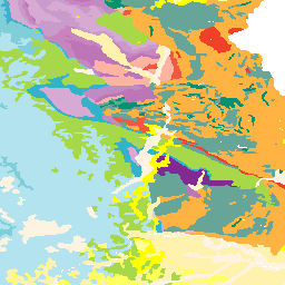
BGR Geological Units (ONEGEOLOGY)
The Geological Map of the Federal Republic of Germany 1 : 1 000 000 (GK1000) pictures the geology of Germany and adjacent areas in detail but clear on one map sheet. This service uses the data of the GK1000 which are therefore limited to the territory of Germany.
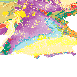
EN BGR 1:1M Geological Units, display by Stratigraphy (ICS/CGMW) (DEU_EN_BGR_1M_Geological_Units)
The Geological Map of the Federal Republic of Germany 1 : 1 000 000 (GK1000) pictures the geology of Germany and adjacent areas in detail but clear on one map sheet. This service uses the data of the GK1000 which are therefore limited to the territory of Germany. The displayed colors are based on the color codes from the Geologic Time Scale 2008 (ICS/CCMW)
There are currently no notifications for the service, click the feed icon to subscribe.