National Centers for Environmental Inf… |
|
Sediment Thickness
http://maps.ngdc.noaa.gov/arcgis/services/web_mercator/sediment_thickness/MapServer/WmsServer

| Service health Now: |
|---|
- Interface
- Web Service, OGC Web Map Service 1.3.0
- Keywords
- Fees
- unknown
- Access constraints
- Whittaker et al (2013); Divins (2003); NOAA National Centers for Environmental Information (NCEI)
- Supported languages
- No INSPIRE Extended Capabilities (including service language support) given. See INSPIRE Technical Guidance - View Services for more information.
- Data provider
-
National Centers for Environmental Information (unverified)
Contact information:
National Centers for Environmental Information
Email:
- Service metadata
- No INSPIRE Extended Capabilities (including service metadata) given. See INSPIRE Technical Guidance - View Services for more information.
Ads by Google
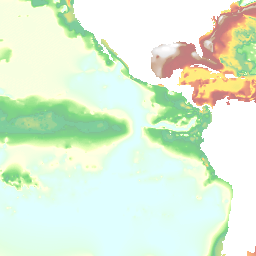
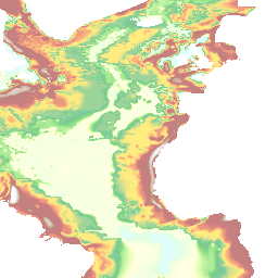
This is a tiled map service displaying a colorized image and contour lines for the Total Sediment Thickness of the World's Oceans & Marginal Seas, Version 2. Grid cell spacing is 5 arc-minutes by 5 arc-minutes. Contour lines and labels are scale-dependent, and the maximum zoom is level 9 (approx. 1:1,116,000).NCEI's global ocean sediment thickness grid (Divins, 2003) has been updated for the Australian-Antarctic region (60°-155°E, 30°-70°S). New seismic reflection and refraction data have been used to add detail to the conjugate Australian and Antarctic margins and intervening ocean floor where previously regional sediment thickness patterns were poorly known.On the margins, sediment thickness estimates were computed from velocity-depth functions from sonobuoy/refraction velocity solutions ground-truthed against seismic reflection data. For the Southeast Indian Ridge abyssal plain, sediment thickness contours from Géli et al. (2007) were used.The new regional sediment thickness grid was combined with NCEI's original ocean sediment thickness grid (Divins, 2003) to create an updated global grid of ocean sediment thickness. Even using the minimum estimates, sediment accumulations on the extended Australian and Antarctic continental margins are 2 km thicker across large regions and up to 9 km thicker in the Ceduna Basin compared to NCEI's original sediment thickness grid (Divins, 2003), which has been deprecated but is still available.For more information, please see: http://ngdc.noaa.gov/mgg/sedthick.ISO metadata for Total Sediment Thickness of the World's Oceans & Marginal Seas, Version 2
Available map layers (5)
sedthick_world_v2.tif (sedthick_world_v2.tif)
2000m index contours - all scales (2000m index contours - all scales)
100m up to 500m - all scales (100m up to 500m - all scales)
500m - large scales (500m - large scales)
500m then every 1000m - small scales (500m then every 1000m - small scales)
There are currently no notifications for the service, click the feed icon to subscribe.