European Commission, Joint Research Ce… |
|
Catchment Characterisation Model (CCM2) - Danube INSPIRE View Service
http://ags-sdi-public.jrc.ec.europa.eu/arcgis/services/CCM2_Danube/MapServer/WMSServer

| Service health Now: |
|---|
- Interface
- Web Service, OGC Web Map Service 1.3.0
- Keywords
- humanGeographicViewer, infoMapAccessService, Hydrography, CCM
- Fees
- Data are provided free of charge for non-commercial use
- Access constraints
- Registration required as a user of the data and acceptance of the conditions of use. More info on http://ccm.jrc.ec.europa.eu
- Supported languages
- eng
- Data provider
-
European Commission, Joint Research Centre (unverified)
Contact information:
Juergen Vogt
European Commission, Joint Research Centre
Email:
- Service metadata
Ads by Google
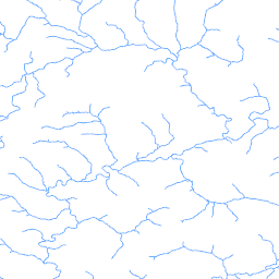
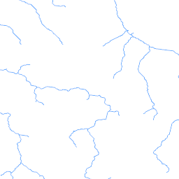
Danube View Service according to the INSPIRE technical guidelines for the Catchment Characterisation Model (CCM) database. Drainage networks and associated drainage basins form complex functional entities not only for hydrological processes but also for environmental processes at large. This has been recognised in recent European legislation such as the Water Framework Directive (WFD). In order to study the underlying processes and cause-effect relationships at regional to European scales, comprehensive digital data of river networks, drainage basins (catchments) and their characteristics are required. JRC's Catchment Characterisation and Modelling (CCM) activity responded to this need through the development of a pan-European database of river networks and catchments. Version 1.0 of CCM has been published in 2003. In July 2007 an geographically extended and substantially improved CCM Version 2.0 has been released. The current Version 2.1 of July 2008 is an update of version 2.0. It includes the correction of noted errors as well additional functionality. A detailed report on the development of CCM 2.0 as well Release Notes for CCM 2.1 are provided on the CCM website
Available map layers (6)
River Segments (0)
The Geodatabase River Segements layer
Main Rivers (1)
The Geodatabase Main Rivers layer
Lakes (2)
All surface water larger than 25 * 25 meters
Catchments (3)
The Geodatabase Primary Catchments layer
RiverBasins (4)
The Geodatabase River Basins layer
Coast (5)
Coast line extracted from image2000 imagery
There are currently no notifications for the service, click the feed icon to subscribe.