The ancient geographes INC |
|
data.fao.org Web Map Service
| Service health Now: |
|---|
- Interface
- Web Service, OGC Web Map Service 1.3.0
- Keywords
- WFS, WMS, GEOSERVER
- Fees
- NONE
- Access constraints
- NONE
- Supported languages
- No INSPIRE Extended Capabilities (including service language support) given. See INSPIRE Technical Guidance - View Services for more information.
- Data provider
-
The ancient geographes INC (unverified)
Contact information:
Claudius Ptolomaeus
The ancient geographes INC
Work:
Alexandria, EgyptEmail:
- Service metadata
- No INSPIRE Extended Capabilities (including service metadata) given. See INSPIRE Technical Guidance - View Services for more information.
Ads by Google
A compliant implementation of WMS plus most of the SLD extension (dynamic styling). Can also generate PDF, SVG, KML, GeoRSS
Available map layers (902)
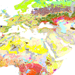
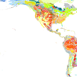
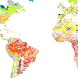
Digital Soil Map of the World (GEONETWORK:DSMW_14116)
Pilot Sites - FDH (GEONETWORK:PilotSites_37988)
Land cover of Uganda - Globcover Regional (GEONETWORK:UGA_gc_adg_37215)
UN Global Coastline (GEONETWORK:UN_coast_poly_31635)
W063S11 Clust (GEONETWORK:W063S11-clust_31636)
WCPFC - Western and Central Pacific Fisheries Commission (GEONETWORK:WCPFC_31675)
Global Dataset of Marine Protected Areas - points (GEONETWORK:WDPA_MPApnt2009_37284)
Global Dataset of Marine Protected Areas - polygons (GEONETWORK:WDPA_MPApol2009_37284)
World Port Index (GEONETWORK:WPI_37285)
Exclusive Economic Zones of the World (GEONETWORK:World_EEZ_31631)
World_EEZ_default_31631 (GEONETWORK:World_EEZ_default_31631)
National boundaries of Africa (2000) (GEONETWORK:adm01_3_1113)
adm_012_a (COMMON:adm_012_a)
adm_012_p (COMMON:adm_012_p)
Sub-national boundaries of Africa_first level (GEONETWORK:adm_1lev_1113)
Sub-national boundaries of Afghanistan - first level (29 Provinces System) (GEONETWORK:adm_1level_29_1209)
Sub-national boundaries of Afghanistan - first level (32 Province System) (GEONETWORK:adm_1level_32_1290)
Sub-national boundaries of Africa_second level (GEONETWORK:adm_2lev_1113)
Sub-national boundaries of Afghanistan - second level (32 Province System) (GEONETWORK:adm_32_1290)
Percentage of area equipped for irrigation (SOLAW:aei_rf_38006)
Proportion of land salinized due to irrigation (SOLAW:aei_sal_38014)
Coast buffer distance of Africa (GEONETWORK:af_3cl_dist_12754)
Water bodies of Africa (GEONETWORK:af_wtr_281)
Soil fertility index for Africa (GEONETWORK:afferll_4)
Sub-national boundaries of Afghanistan - second level (29 Provinces System) (GEONETWORK:afg_adm_1209)
Dominant soils of Africa (GEONETWORK:afgrouso_3)
National administrative boundaries of Africa (GEONETWORK:afr_adm_1)
Sub-national administrative boundaries of Africa (1993) OGC map (GEONETWORK:afr_adm_2)
Major Climates of Africa (GEONETWORK:afr_mcli_6)
Rainfall Monitoring for the African Continent (GEONETWORK:afr_raiper_2008_10_36920)
Rainfall Monitoring for the African Continent (GEONETWORK:afr_raitot_2008_10_36920)
Dominant Soil Constraints in Africa (GEONETWORK:afsoil_12750)
Land use - Land cover of Africa (GEONETWORK:afusgs1_llb_12755)
Land cover of Angola - Globcover Regional (GEONETWORK:ago_gc_adg_37168)
Aridity Index (GEONETWORK:aird5m_w_12739)
Mean monthly air temperature of Africa for the month of July (GEONETWORK:airtmp7_3825)
Mean monthly air temperature of Africa for the month of January (GEONETWORK:airtmp_mn_23)
Suitability of global land area for rainfed crops, using maximising crop and technology mix (FGGD) (GEONETWORK:all_crop_14171)
Suitability of currently available land area for rainfed crops, using maximising crop and technology mix (FGGD) (GEONETWORK:all_crop_a_14172)
Global fishery resources distribution of Alopias pelagicus (GEONETWORK:alo_pel_31672)
APFIC - ASIA-PACIFIC Fisheries Commission (GEONETWORK:apfic_31675)
Total Ponds Area - Livestock and Aquaculture in Myanmar (GEONETWORK:aquaculture_31677)
areas_25nauticalmiles_fromports_37303 (GEONETWORK:areas_25nauticalmiles_fromports_37303)
Areas within 25 nautical miles (46.3 km) of a port [Map unit: Km]
aridity (AQUASTAT:aridity)
Global map of aridity - 10 arc minutes (AQUASTAT:aridity_37040)
ASFA Geographic References (GEONETWORK:asfa_31628)
at_boundaries (AQUASTAT:at_boundaries)
at_boundaries (COMMON:at_boundaries)
at_boundaries (GAEZ:at_boundaries)
background (COMMON:background)
Bailey's Global Map of Ecoregions (GEONETWORK:bailey_1038)
Occurrence of barren and sparsely vegetated land (FGGD) (GEONETWORK:barren_14069)
bas_hydrosheds_v2_42506 (GEONETWORK:bas_hydrosheds_v2_42506)
Sub-basin delineation []
World map of the major hydrological basins (Derived from HydroSHEDS) (SOLAW:bas_wrld_38047)
Hydrological basins in Africa (GEONETWORK:basins_296)
Global distribution of physical water scarcity by major river basin (SOLAW:basins_ws_38002)
Land cover of Burundi - Globcover Regional (GEONETWORK:bdi_gc_adg_37169)
Land cover of Benin - Globcover Regional (GEONETWORK:ben_gc_adg_37167)
Land cover of Burkina Faso - Globcover Regional (GEONETWORK:bfa_gc_adg_37176)
Built-up Areas of the World (Vmap0) (GEONETWORK:bltupa_1278)
BOBP-IGO - Bay of Bengal Programme (GEONETWORK:bobp-igo_31675)
breed_location (DADIS:breed_location)
bu-lc_agg_38177 (GEONETWORK:bu-lc_agg_38177)
Spatially Aggregated Multipurpose Landcover Database for Burundi [Class]
Aggregated landcover database for Burundi (Africover) for tsetse habitat mapping (GEONETWORK:bu_31128)
Land cover of Botswana - Globcover Regional (GEONETWORK:bwa_gc_adg_37170)
Potential livestock wastes and agricultural by-products as feed and fertilizer input (GEONETWORK:byprod_sl_3798)
Land cover of Central African Republic - Globcover Regional (GEONETWORK:caf_gc_adg_37171)
Hotspots in Central America where forest is dominantly replaced by cropland (GEONETWORK:camcrop_difhs_12256)
Diffuse deforestation areas in Central America with overlap of cropland and pasture (GEONETWORK:camcrop_hs_12256)
Diffuse deforestation areas in Central America where forest is dominantly replaced by cropland (GEONETWORK:camcropast_difhs_12256)
camel (GLIPHA:camel)
Diffuse deforestation areas in Central America where forest is dominantly replaced by pasture (GEONETWORK:campast_difhs_12256)
Hotspots in Central America where forest is dominantly replaced by pasture (GEONETWORK:campast_hs_12256)
canals_42508 (GEONETWORK:canals_42508)
Ancillary datasets - Canals []
cattle1km_ad_2010_v2_1 (GLIPHA:cattle1km_ad_2010_v2_1)
Total Cattle - Livestock and Aquaculture in Myanmar (GEONETWORK:cattle_31678)
Estimated Beef Surplus/Deficit (GEONETWORK:cattle_kgkm2_31648)
Proportion of feed N retained in product - beef cattle herd (GEONETWORK:cb_nreteined_48354)
CCAMLR - Commission on the Conservation of Antartic Marine Living Resources (GEONETWORK:ccamlr_31675)
CCBSP - The Convention on the Conservation and Management of the Pollock Resources in the Central Bering Sea (GEONETWORK:ccbsp_31675)
Potential yield (crops/y) of carp fed at 75% satiation and harvested at 600 g (GEONETWORK:ccr750600_3852)
CCSBT - Commission for the Conservation of Southern Bluefin Tuna (GEONETWORK:ccsbt_31675)
Proportion of feed N retained in product - dairy cattle herd (GEONETWORK:cd_nreteined_48353)
CECAF - Fishery Committee for the Eastern Central Atlantic (GEONETWORK:cecaf_31675)
centroid (COMMON:centroid)
centroid_iso3 (AQUASTAT:centroid_iso3)
Estimated Feed Surplus/Deficit - Cereals (pig and poultry) (GEONETWORK:cer_kgkm2_31646)
Suitability of global land area for rainfed production of cereals (high level of inputs) (FGGD) (GEONETWORK:cereal_hig_14084)
Suitability of currently available land for rainfed production of cereals (high level of inputs) (FGGD) (GEONETWORK:cereal_hig_a_14080)
Suitability of global land area for rainfed production of cereals (intermediate level of inputs) (FGGD) (GEONETWORK:cereal_int_14077)
Suitability of currently available land for rainfed production of cereals (intermediate level of inputs) (FGGD) (GEONETWORK:cereal_int_a_14079)
Suitability of global land area for rainfed production of cereals (low level of inputs) (FGGD) (GEONETWORK:cereal_low_14076)
Suitability of currently available land for rainfed production of cereals (low level of inputs) (FGGD) (GEONETWORK:cereal_low_a_14085)
chickens1km_ad_2010_v2_01 (GLIPHA:chickens1km_ad_2010_v2_01)
CIFAA - Committee for Inland Fisheries and Aquaculture of Africa (GEONETWORK:cifa_31675)
Major cities of Africa (GEONETWORK:cities_15)
Land cover of Cote d'Ivoire - Globcover Regional (GEONETWORK:civ_gc_adg_37177)
Moisture regimes - LPJM - AI LGPt - current period 1991-2020 (GEONETWORK:climaf_1_1981_2050_lpjm_mir5_aezai_ann_avgcur05_47952)
Moisture regimes - LPJM - AI LGPt - future period 2001-2030 (GEONETWORK:climaf_1_1981_2050_lpjm_mir5_aezai_ann_avgfut15_47952)
Moisture regimes - LPJM - AI LGPt - future period 2010-2040 (GEONETWORK:climaf_1_1981_2050_lpjm_mir5_aezai_ann_avgfut25_47952)
Moisture regimes - LPJM - AI LGPt - future period 2020-2050 (GEONETWORK:climaf_1_1981_2050_lpjm_mir5_aezai_ann_avgfut35_47952)
Moisture regimes - LPJM - AI LGPt - historical period 1981-2010 (GEONETWORK:climaf_1_1981_2050_lpjm_mir5_aezai_ann_avghis95_47952)
Moisture regimes - LPJM - LGPeq - current period 1991-2020 (GEONETWORK:climaf_1_1981_2050_lpjm_mir5_aezlg_ann_avgcur05_47952)
Moisture regimes - LPJM - LGPeq - future period 2001-2030 (GEONETWORK:climaf_1_1981_2050_lpjm_mir5_aezlg_ann_avgfut15_47952)
Moisture regimes - LPJM - LGPeq - future period 2010-2040 (GEONETWORK:climaf_1_1981_2050_lpjm_mir5_aezlg_ann_avgfut25_47952)
Moisture regimes - LPJM - LGPeq - future period 2020-2050 (GEONETWORK:climaf_1_1981_2050_lpjm_mir5_aezlg_ann_avgfut35_47952)
Moisture regimes - LPJM - LGPeq - historical period 1981-2010 (GEONETWORK:climaf_1_1981_2050_lpjm_mir5_aezlg_ann_avghis95_47952)
Suitability index changes (2050) (GEONETWORK:climaf_suitweight_dif_fut35his95_12crops_47958)
Vulnerability index (2010) (GEONETWORK:climafr01_vulnerability_index_48360)
Exposure index (2010) (GEONETWORK:climafr02_exposure_index_48361)
Sensitivity index (2010) (GEONETWORK:climafr03_sensitivity_index_48362)
Adaptive capacity index (2010) (GEONETWORK:climafr04_adaptive_capacity_index_48363)
Human sensitivity index (2010) (GEONETWORK:climafr05_human_sensitivity_index_48364)
Natural sensitivity index (2010) (GEONETWORK:climafr06_natural_sensitivity_index_48365)
Human capital index (2010) (GEONETWORK:climafr07_human_capital_index_48366)
Technological capital index (2010) (GEONETWORK:climafr08_techno_capital_index_48367)
Financial capital index (2010) (GEONETWORK:climafr09_financial_capital_index_48368)
Institutional capital index (2010) (GEONETWORK:climafr10_institutional_capital_index_48372)
Element at risk index (2010) (GEONETWORK:climafr11_elementatrisk_index_48373)
Climatic stress index (2010) (GEONETWORK:climafr12_climatic_stress_index_48374)
Rurality index (2010) (GEONETWORK:climafr13_rurality_index_48375)
Malnourishment index (2010) (GEONETWORK:climafr14_malnourishment_index_48376)
Gender gap index (2010) (GEONETWORK:climafr15_gender_gap_index_48377)
Natural resources sensitivity index (2010) (GEONETWORK:climafr16_natural_resources_sens_index_48378)
Agriculture resources sensitivity index (2010) (GEONETWORK:climafr17_agri_resources_sens_index_48379)
Water stress sensitivity index (2010) (GEONETWORK:climafr18_water_stress_index_48382)
Public health index (2010) (GEONETWORK:climafr19_public_health_index_48383)
Motherhood and childhood health index (2010) (GEONETWORK:climafr20_motherchild_health_index_48384)
Education index (2010) (GEONETWORK:climafr21_education_index_48381)
Household technology index (2010) (GEONETWORK:climafr22_household_technology_index_48385)
Infrastructure index (2010) (GEONETWORK:climafr23_infrastructure_index_48388)
Financial development index (2010) (GEONETWORK:climafr24_financial_develop_index_48387)
Richness index (2010) (GEONETWORK:climafr25_richness_index_48369)
Governance index (2010) (GEONETWORK:climafr26_governance_index_48370)
Conflictuality index (2010) (GEONETWORK:climafr27_conflict_index_48371)
Environmental management index (2010) (GEONETWORK:climafr28_env_management_index_48386)
Land cover of Cameroon - Globcover Regional (GEONETWORK:cmr_gc_adg_37178)
Congo forest cover and loss map 2000-2012 (GEONETWORK:cniaff_congo_forest_loss_2000_2012_5566)
Global International Boundaries (GEONETWORK:cnt1m_jun05_6110)
Coastal and country boundaries of the world (GEONETWORK:cnt_bnd_vect_14039)
Simplified world country boundary (GEONETWORK:cntsim_12279)
World coast buffer line (GEONETWORK:coast_buf4_12756)
World Coastline and International Boundaries (DCW) (GEONETWORK:coastl_1112)
Coastline of the World (Vmap0) (GEONETWORK:coastline_1267)
coasts (GAEZ:coasts)
Land cover of Democratic Republic of the Congo - Globcover Regional (GEONETWORK:cod_gc_adg_37219)
COFREMAR - Joint Technical Commission for the ARGENTINA/URUGUAY Maritime Front (GEONETWORK:cofremar_31675)
Land cover of Congo - Globcover Regional (GEONETWORK:cog_gc_adg_37179)
Commercial fish farming potential (GEONETWORK:com_fish_3841)
Land cover of Comoros - Globcover Regional (GEONETWORK:com_gc_adg_37180)
Suitability for commercial fish farming (GEONETWORK:com_mld_3847)
Combined suitability of global land area for pasture and rainfed crops (high input level) (FGGD) (GEONETWORK:comb_hig_14175)
Combined suitability of currently available land for pasture and rainfed crops (high input level) (FGGD) (GEONETWORK:comb_hig_a_14178)
Combined suitability of global land area for pasture and rainfed crops (intermediate input level) (FGGD) (GEONETWORK:comb_int_14174)
Combined suitability of currently available land for pasture and rainfed crops (intermediate input level) (FGGD) (GEONETWORK:comb_int_a_14177)
Combined suitability of global land area for pasture and rainfed crops (low input level) (FGGD) (GEONETWORK:comb_low_14173)
Combined suitability of currently available land for pasture and rainfed crops (low input level) (FGGD) (GEONETWORK:comb_low_a_14176)
Suitability of Soil conditions for Soil Carbon Sequestration (GEONETWORK:comb_sotex_12736)
combine_data_02 (GAEZ:combine_data_02)
Suitability for commercial fish farming (GEONETWORK:comerc_3802)
COMHAFAT (GEONETWORK:comhafat_31675)
Global land area with climate constraints (FGGD) (GEONETWORK:constr_clim_14132)
Hierarchical distribution of severe environmental constraints (FGGD) (GEONETWORK:constr_hier_14065)
Global land area with terrain slope constraints (FGGD) (GEONETWORK:constr_slope_14075)
Global land area with soil constraints (FGGD) (GEONETWORK:constr_soil_14133)
Spatial distribution of constraints (GEONETWORK:constraints_3795)
COPESCAL - Commission for Inland Fisheries of Latin America (GEONETWORK:copescal_31675)
COREP - Regional Fisheries Committee for the Gulf of Guinea (GEONETWORK:corep_31675)
Cost grid (GEONETWORK:costgrd_3824)
countries (COMMON:countries)
country (COMMON:country)
country_bbox (COMMON:country_bbox)
Country boundaries of the world (grid version) (FGGD) (GEONETWORK:country_bnd_31144)
country_boundaries (COMMON:country_boundaries)
country_lines (COMMON:country_lines)
country_point_on_surface (COMMON:country_point_on_surface)
cov01_42660 (AQUAMAPS:cov01_42660)
Coefficient of variation of precipitation - jan [Map unit: CV]
cov02_42660 (AQUAMAPS:cov02_42660)
Coefficient of variation of precipitation - feb [Map unit: CV]
cov03_42660 (AQUAMAPS:cov03_42660)
Coefficient of variation of precipitation - mar [Map unit: CV]
cov04_42660 (AQUAMAPS:cov04_42660)
Coefficient of variation of precipitation - apr [Map unit: CV]
cov05_42660 (AQUAMAPS:cov05_42660)
Coefficient of variation of precipitation - may [Map unit: CV]
cov06_42660 (AQUAMAPS:cov06_42660)
Coefficient of variation of precipitation - jun [Map unit: CV]
cov07_42660 (AQUAMAPS:cov07_42660)
Coefficient of variation of precipitation - jul [Map unit: CV]
cov08_42660 (AQUAMAPS:cov08_42660)
Coefficient of variation of precipitation - aug [Map unit: CV]
cov09_42660 (AQUAMAPS:cov09_42660)
Coefficient of variation of precipitation - sep [Map unit: CV]
cov10_42660 (AQUAMAPS:cov10_42660)
Coefficient of variation of precipitation - oct [Map unit: CV]
cov11_42660 (AQUAMAPS:cov11_42660)
Coefficient of variation of precipitation - nov [Map unit: CV]
cov12_42660 (AQUAMAPS:cov12_42660)
Coefficient of variation of precipitation - dec [Map unit: CV]
Potential yield (crops/y) of pacu fed at 75% satiation and harvested at 600 g (GEONETWORK:cpc750600_3850)
Occurrence of cropland (FGGD) (GEONETWORK:cropland_14067)
Cropland areas (GEONETWORK:crops_3823)
Potential for agricolture by-products as feed and fertiliser inputs (GEONETWORK:crops_3845)
Land Suitability Index for sugarcane in Peru - Available area (GEONETWORK:cs_cana_area_dispon_54461)
Land Suitability Index for white pinon in Peru - Available area (GEONETWORK:cs_jatr_area_dispon_54463)
Land Suitability Index for oil palm in Peru - Available area (GEONETWORK:cs_palm_area_dispon_54462)
Potential yield (crops/y) of tambaqui fed at 75% satiation and harvested at 600 g (GEONETWORK:ctb750600_3849)
Potential yield of Nile tilapia with a CFB of 0.075 kg/m3 and harvested at 150g. (GEONETWORK:ctl000150_3853)
Potential yield (crops/y) of Nile tilapia fed at 75% satiation and harvested at 300 g (GEONETWORK:ctl750300_3851)
current_speeds_10_100_cms_37326 (GEONETWORK:current_speeds_10_100_cms_37326)
Current speeds at 30m depth between 10 and 100 cm/s for all months in the year [Map unit: cm/sec]
Global fishery resources distribution of Acipenser sturio (GEONETWORK:d1_apu_31673)
Global fishery resources distribution of Boops boops (GEONETWORK:d1_bog_31670)
Global fishery resources distribution of Squalus japonicus (GEONETWORK:d1_quj_31641)
dadis_curhabit (MAPSET:dadis_curhabit)
dadis_pothabit (MAPSET:dadis_pothabit)
Dams in Africa (GEONETWORK:dams_africa_38077)
dams_middleeast_38078 (AQUAMAPS:dams_middleeast_38078)
dark_bluemarble (COMMON:dark_bluemarble)
data_by_indicator (AQUASTAT:data_by_indicator)
Distribution of poor population in developing countries, based on stunting among children (SOLAW:den_stunt_38216)
Global Depth Contours (GEONETWORK:depth_contours_31632)
Administrative Boundaries of Myanmar - District level (GEONETWORK:dist64_31686)
Administrative Boundaries of Myanmar - Division/State level (GEONETWORK:div17_31686)
Land cover of Djibouti - Globcover Regional (GEONETWORK:dji_gc_adg_37181)
Dominant Land Cover and Use (SOLAW:dom_lu_38215)
dom_soil (COUNTRYPROFILES:dom_soil)
Dominant Soils (GEONETWORK:dom_soil_30587)
drc-lc_agg_38090 (GEONETWORK:drc-lc_agg_38090)
Spatially Aggregated Multipurpose Landcover Database for DR Congo [Class]
dt_gaul_bbox (COMMON:dt_gaul_bbox)
dt_gaul_geom (COMMON:dt_gaul_geom)
dt_gaul_geom_by_gaul (COMMON:dt_gaul_geom_by_gaul)
Land cover of Algeria - Globcover Regional (GEONETWORK:dza_gc_adg_37164)
Rainfall Monitoring by Region for the African Continent: Eastern Africa (GEONETWORK:eaf_raiper_2008_9_36923)
Rainfall Monitoring by Region for the African Continent: Eastern Africa (GEONETWORK:eaf_raitot_2008_10_36923)
Global Ecological Zones (GEONETWORK:eco_zone_1255)
economic_groups (FAODATA:economic_groups)
eg-lc_agg_38180 (GEONETWORK:eg-lc_agg_38180)
Spatially Aggregated Multipurpose Landcover Database for Egypt [Class]
Land cover of Egypt - Globcover Regional (GEONETWORK:egy_gc_adg_37182)
Carbon dioxide emission intensity per unit of edible protein (GEONETWORK:eiedi75prot_48348)
EIFAC - European Inland Fisheries Advisory Commission (GEONETWORK:eifac_31675)
entebbe_dams_42504 (GEONETWORK:entebbe_dams_42504)
Dams and main irrigation areas []
entebbe_runoff_arcs_42507 (GEONETWORK:entebbe_runoff_arcs_42507)
Hydrologic regime [Map unit: Km� (cubic Km)]
envfacll (COUNTRYPROFILES:envfacll)
er-lc_agg_38185 (GEONETWORK:er-lc_agg_38185)
Spatially Aggregated Multipurpose Landcover Database for Eritrea [Class]
Land cover of Eritrea - Globcover Regional (GEONETWORK:eri_gc_adg_37183)
World cities (GEONETWORK:esri_cities_12764)
World Rivers (GEONETWORK:esri_rivers_12765)
Land Cover of Ethiopia - Globcover Regional (GEONETWORK:eth_gc_adg_37184)
Global map of monthly reference evapotranspiration - 10 arc-min - January (AQUAMAPS:eto01_7416)
Global map of monthly reference evapotranspiration - 10 arc-min - February (AQUAMAPS:eto02_7416)
Global map of monthly reference evapotranspiration - 10 arc-min - March (AQUAMAPS:eto03_7416)
Global map of monthly reference evapotranspiration - 10 arc-min - April (AQUAMAPS:eto04_7416)
Global map of monthly reference evapotranspiration - 10 arc-min - May (AQUAMAPS:eto05_7416)
Global map of monthly reference evapotranspiration - 10 arc-min - June (AQUAMAPS:eto06_7416)
Global map of monthly reference evapotranspiration - 10 arc-min - July (AQUAMAPS:eto07_7416)
Global map of monthly reference evapotranspiration - 10 arc-min - August (AQUAMAPS:eto08_7416)
Global map of monthly reference evapotranspiration - 10 arc-min - September (AQUAMAPS:eto09_7416)
Global map of monthly reference evapotranspiration - 10 arc-min - October (AQUAMAPS:eto10_7416)
Global map of monthly reference evapotranspiration - 10 arc-min - November (AQUAMAPS:eto11_7416)
Global map of monthly reference evapotranspiration - 10 arc-min - December (AQUAMAPS:eto12_7416)
Global map of monthly reference evapotranspiration - 10 arc-min (AQUAMAPS:etoyr_7416)
Global map of montly reference evapotranspiration - 30 arc-min (GEONETWORK:etref_apr_5017)
Global map of montly reference evapotranspiration - 30 arc-min (GEONETWORK:etref_aug_5017)
Global map of montly reference evapotranspiration - 30 arc-min (GEONETWORK:etref_dec_5017)
Global map of montly reference evapotranspiration - 30 arc-min (GEONETWORK:etref_feb_5017)
Global map of montly reference evapotranspiration - 30 arc-min (GEONETWORK:etref_jan_5017)
Global map of montly reference evapotranspiration - 30 arc-min (GEONETWORK:etref_jul_5017)
Global map of montly reference evapotranspiration - 30 arc-min (GEONETWORK:etref_jun_5017)
Global map of montly reference evapotranspiration - 30 arc-min (GEONETWORK:etref_mar_5017)
Global map of montly reference evapotranspiration - 30 arc-min (GEONETWORK:etref_may_5017)
Global map of montly reference evapotranspiration - 30 arc-min (GEONETWORK:etref_nov_5017)
Global map of montly reference evapotranspiration - 30 arc-min (GEONETWORK:etref_oct_5017)
Global map of montly reference evapotranspiration - 30 arc-min (GEONETWORK:etref_sep_5017)
Global map of montly reference evapotranspiration - 30 arc-min (GEONETWORK:etref_year_5017)
Soil of North and Central Eurasia (GEONETWORK:eurasia_taiwsoil_7385)
evapo_y_nile_42505 (GEONETWORK:evapo_y_nile_42505)
Actual annual evapotranspiration [Map unit: mm]
Net annual water loss from ponds through evaporation and seepage (GEONETWORK:evpseep_3846)
Monthly potential evapotranspiration of Africa for the month of July (GEONETWORK:evptr7_3818)
Environmental and land use constraints for bioenergy purpose in Tanzania (GEONETWORK:excluded_areas_54460)
Share of population living in extreme poverty (GEONETWORK:ext_poverty_14119)
FAO Fishing Major Areas (GEONETWORK:fa_areas_31627)
FAO Fishing Divisions (GEONETWORK:fa_division_31627)
FAO Fishing Sub Areas (GEONETWORK:fa_subareas_31627)
FAO Fishing Sub Divisions (GEONETWORK:fa_subdivision_31627)
FAO Fishing Sub Units (GEONETWORK:fa_subunit_31627)
faostat_area (FAODATA:faostat_area)
faostat_area_p (FAODATA:faostat_area_p)
faostat_area_r (FAODATA:faostat_area_r)
Population growth FAOSTAT (1991-2020) (GEONETWORK:faostat_growthrate_afr_cur05_47963)
Population growth FAOSTAT (2010-2040) (GEONETWORK:faostat_growthrate_afr_fut25_47963)
Population growth FAOSTAT (1920-2050) (GEONETWORK:faostat_growthrate_afr_fut35_47963)
Farming system classes in developing and transition countries, 2000 (FGGD) (GEONETWORK:farm_sys_14074)
Potential for farm-gate sales (GEONETWORK:farmgate_3799)
farmsys2_38023 (SOLAW:farmsys2_38023)
FFA - Forum Fisheries Agency (GEONETWORK:ffa_31675)
Potential for farm gate sales (GEONETWORK:fgs_3843)
Yield gap for a combination of major crops (SOLAW:fi2_023_37999)
Suitability of global land area for rainfed production of fibres (high level of inputs) (FGGD) (GEONETWORK:fibres_hig_14078)
Suitability of currently available land for rainfed production of fibres (high level of inputs) (FGGD) (GEONETWORK:fibres_hig_a_14089)
Suitability of global land area for rainfed production of fibres (intermediate level of inputs) (FGGD) (GEONETWORK:fibres_int_14082)
Suitability of currently available land for rainfed production of fibres (intermediate level of inputs) (FGGD) (GEONETWORK:fibres_int_a_14086)
Suitability of global land area for rainfed production of fibres (low level of inputs) (FGGD) (GEONETWORK:fibres_low_14081)
Suitability of currently available land for rainfed production of fibres (low level of inputs) (FGGD) (GEONETWORK:fibres_low_a_14083)
Dominant soil and terrain constraints for low input farming (SOLAW:fig02_06_37990)
Global Positive Trend of Climate-Adjusted NDVI (1981-2003) (GEONETWORK:fig10_37057)
Global Change In Net Primary Productivity (1981-2003) (GEONETWORK:fig2_37049)
Global Change in Rain-Use Efficiency 1981-2003 (GEONETWORK:fig3_37051)
Global Correlation Between Annual Sum NDVI And Annual Rainfall 1981-2003 (GEONETWORK:fig4_37052)
Global Negative Trend in RUE-adjusted NDVI (1981-2003) (GEONETWORK:fig5_37053)
Global NPP Loss In The Degrading Areas (1981-2003) (GEONETWORK:fig6_37055)
Global Residual Trend of Sum NDVI (RESTREND) 1981-2003 (GEONETWORK:fig7_37056)
Global Positive Trend of RUE-Adjusted NDVI (1981-2003) (GEONETWORK:fig_missing_37061)
Global multi-year mean annual sum NDVI 1981-2003 - IMG format (GEONETWORK:figs5a_37058)
Global trend in annual sum NDVI 1981-2003 (% change) (GEONETWORK:figs5b_37058)
Global changes in annual sum NDVI 1981-2003 (absolute change) (GEONETWORK:figs5c_37058)
Global confidence levels of trend in annual sum NDVI 1981-2003 (GEONETWORK:figs5d_37058)
Global Pattern, Trends and Confidence Levels of NDVI Standard Deviation (1981-2003) (GEONETWORK:figs6a_37059)
Global Pattern, Trends and Confidence Levels of NDVI Standard Deviation (1981-2003) (GEONETWORK:figs6b_37059)
Global Pattern, Trends and Confidence Levels of NDVI Standard Deviation (1981-2003) (GEONETWORK:figs6c_37059)
Global Pattern, Trends and Confidence Levels of NDVI Standard Deviation (1981-2003) (GEONETWORK:figs6d_37059)
Global multi-year mean annual NDVI coefficient of variation 1981-2003 (GEONETWORK:figs7a_37060)
Global trend in annual NDVI coefficient of variation 1981-2003 (% change) (GEONETWORK:figs7b_37060)
Global changes in annual NDVI coefficient of variation 1981-2003 (absolute change) (GEONETWORK:figs7c_37060)
Global confidence levels of trend in annual NDVI coefficient of variation 1981-2003 (GEONETWORK:figs7d_37060)
title to be set (GEONETWORK:fish_hatch_single_56894)
fisheries_country (FAODATA:fisheries_country)
fisheries_fishing_area (FAODATA:fisheries_fishing_area)
The World's Forests 2000 (GEONETWORK:for_2000_1253)
Land Cover of East Timor (GEONETWORK:forcover_2_1285)
Occurrence of forest (FGGD) (GEONETWORK:forest_14066)
fra2010 (FORESTRY:fra2010)
Suitability of global land area for rainfed production of tree fruits (high level of inputs) (FGGD) (GEONETWORK:fruit_hig_14157)
Suitability of currently available land for rainfed production of tree fruits (high level of inputs) (FGGD) (GEONETWORK:fruit_hig_a_14161)
Suitability of global land area for rainfed production of tree fruits (intermediate level of inputs) (FGGD) (GEONETWORK:fruit_int_14156)
Suitability of currently available land for rainfed production of tree fruits (intermediate level of inputs) (FGGD) (GEONETWORK:fruit_int_a_14159)
Suitability of global land area for rainfed production of tree fruits (low level of inputs) (FGGD) (GEONETWORK:fruit_low_14155)
Suitability of currently available land for rainfed production of tree fruits (low level of inputs) (FGGD) (GEONETWORK:fruit_low_a_14158)
title to be set (GEONETWORK:fs_level_1_2010_56894)
title to be set (GEONETWORK:fs_level_2_2010_56894)
fs_nile_gmia_41331 (GEONETWORK:fs_nile_gmia_41331)
Farming systems [Map unit: class]
fsatmis_country_allocation (FSATMIS:fsatmis_country_allocation)
fsatmis_country_commitment (FSATMIS:fsatmis_country_commitment)
fsatmis_district_allocation (FSATMIS:fsatmis_district_allocation)
fsatmis_district_commitment (FSATMIS:fsatmis_district_commitment)
fsatmis_province_allocation (FSATMIS:fsatmis_province_allocation)
fsatmis_province_commitment (FSATMIS:fsatmis_province_commitment)
GAUL - country level - Reference year 2006 (GEONETWORK:g2008_0_12691)
GAUL - first level - Reference year 2006 (GEONETWORK:g2008_1_12691)
GAUL - second level - Reference year 2006 (GEONETWORK:g2008_2_12691)
g2013 (COUNTRYPROFILES:g2013)
g2013_mask (COUNTRYPROFILES:g2013_mask)
g2013_mask_2 (COUNTRYPROFILES:g2013_mask_2)
g2015_2014_0_cio_p03 (COMMON:g2015_2014_0_cio_p03)
g2015_2014_1_cio_p03 (COMMON:g2015_2014_1_cio_p03)
Land cover of Gabon - Globcover Regional (GEONETWORK:gab_gc_adg_37185)
gaez_ayapro_cpv (MAPSET:gaez_ayapro_cpv)
gaez_ayapro_crp (MAPSET:gaez_ayapro_crp)
gaez_zones (GAEZ:gaez_zones)
GAUL Simplified Coastline (GEONETWORK:gaul2006_coast_31671)
gaul2008_0 (SOLAW:gaul2008_0)
gez2010 (FORESTRY:gez2010)
GFCM - General Fisheries Commission for the Mediterranean (GEONETWORK:gfcm_31675)
Land cover of Ghana - Globcover Regional (GEONETWORK:gha_gc_adg_37186)
Carbon dioxide emission intensity per pixel (GEONETWORK:ghgedi_km2_48349)
Carbon dioxide emission intensity per unit of human population (GEONETWORK:ghgedi_nh_48350)
Land cover of Guinea - Globcover Regional (GEONETWORK:gin_gc_adg_37187)
gl_0_12 (COMMON:gl_0_12)
glbbf05 (COUNTRYPROFILES:glbbf05)
Global Buffalo Density (2005) (GEONETWORK:glbbfd1f0503m_12714)
glbbvd (COUNTRYPROFILES:glbbvd)
Global Bovine Density (2005) (GEONETWORK:glbbvd1f0503m_12715)
glbct05 (COUNTRYPROFILES:glbct05)
Global Cattle Density (2005) (GEONETWORK:glbctd1f0503m_12713)
glbgt05 (COUNTRYPROFILES:glbgt05)
Global Goat Density (2005) (GEONETWORK:glbgtd1f0503m_12717)
glbpg05 (COUNTRYPROFILES:glbpg05)
Global Pig Density (2005) (GEONETWORK:glbpgd1f0503m_12719)
glbpo05 (COUNTRYPROFILES:glbpo05)
Global Poultry Density (2005) (GEONETWORK:glbpod1f0503m_12720)
glbsh05 (COUNTRYPROFILES:glbsh05)
Global Sheep density (2005) (GEONETWORK:glbshd1f0503m_12716)
Global Small Ruminant Density (2005) (GEONETWORK:glbsrd1f0503m_12718)
glc_shv10_01_47948 (GEONETWORK:glc_shv10_01_47948)
glc_shv10_02_47948 (GEONETWORK:glc_shv10_02_47948)
glc_shv10_03_47948 (GEONETWORK:glc_shv10_03_47948)
glc_shv10_04_47948 (GEONETWORK:glc_shv10_04_47948)
glc_shv10_05_47948 (GEONETWORK:glc_shv10_05_47948)
glc_shv10_06_47948 (GEONETWORK:glc_shv10_06_47948)
glc_shv10_07_47948 (GEONETWORK:glc_shv10_07_47948)
glc_shv10_08_47948 (GEONETWORK:glc_shv10_08_47948)
glc_shv10_09_47948 (GEONETWORK:glc_shv10_09_47948)
glc_shv10_10_47948 (GEONETWORK:glc_shv10_10_47948)
glc_shv10_11_47948 (GEONETWORK:glc_shv10_11_47948)
glc_shv10_dom_47948 (GEONETWORK:glc_shv10_dom_47948)
globcover (AQUASTAT:globcover)
globcover (COUNTRYPROFILES:globcover)
Aquatic species distribution maps of interest to fisheries (GEONETWORK:globdens_31027)
Land cover of Gambia - Globcover Regional (GEONETWORK:gmb_gc_adg_37188)
Global map of irrigation areas (AQUAMAPS:gmia_v4_0_1_pct_5020)
gmia_v5_aeipc_5020 (AQUAMAPS:gmia_v5_aeipc_5020)
Global Map of Irrigation Areas - Version 5 [Class]
Land cover of Guinea-Bissau - Globcover Regional (GEONETWORK:gnb_gc_adg_37189)
Land cover of Equatorial Guinea - Globcover Regional (GEONETWORK:gnq_gc_adg_37190)
goats1km_ad_2010_v2_1 (GLIPHA:goats1km_ad_2010_v2_1)
Vector Grid at 5x5 Degrees Resolution (GEONETWORK:gr5x5_31634)
Gray Earth with Shaded Relief and Hypsography (COMMON:gray_hr_sr)
Relief shading and hypsography derive from modified SRTM Plus elevation data at 1km resolution. Modifications include patching the eastern Himalayas and southern Andes with better elevation data from Viewfinder Panoramas. Daniel Huffman, University of Wisconsin, Madison, created the regionally equalized hypsography that forms the foundation of Gray Earth.
Gray Earth with Shaded Relief, Hypsography, and Flat Water (COMMON:gray_hr_sr_w)
Relief shading and hypsography derive from modified SRTM Plus elevation data at 1km resolution. Modifications include patching the eastern Himalayas and southern Andes with better elevation data from Viewfinder Panoramas. Daniel Huffman, University of Wisconsin, Madison, created the regionally equalized hypsography that forms the foundation of Gray Earth.
Gray Earth with Shaded Relief, Hypsography, and Flat Water - edited - 1 (COMMON:gray_hr_sr_w_1)
Relief shading and hypsography derive from modified SRTM Plus elevation data at 1km resolution. Modifications include patching the eastern Himalayas and southern Andes with better elevation data from Viewfinder Panoramas. Daniel Huffman, University of Wisconsin, Madison, created the regionally equalized hypsography that forms the foundation of Gray Earth.
Gray Earth with Shaded Relief, Hypsography, and Flat Water - edited - 2 (COMMON:gray_hr_sr_w_2)
Relief shading and hypsography derive from modified SRTM Plus elevation data at 1km resolution. Modifications include patching the eastern Himalayas and southern Andes with better elevation data from Viewfinder Panoramas. Daniel Huffman, University of Wisconsin, Madison, created the regionally equalized hypsography that forms the foundation of Gray Earth.
Gray Earth with Shaded Relief, Hypsography, and Flat Water - edited - 3 (COMMON:gray_hr_sr_w_3)
Relief shading and hypsography derive from modified SRTM Plus elevation data at 1km resolution. Modifications include patching the eastern Himalayas and southern Andes with better elevation data from Viewfinder Panoramas. Daniel Huffman, University of Wisconsin, Madison, created the regionally equalized hypsography that forms the foundation of Gray Earth.
GEBCO One Minute Grid - ESRI Grid (GEONETWORK:gridone_31633)
Degree of human development (GEONETWORK:hdi_2000_14117)
Dynamic map of Holdridge Life-Zone map (GEONETWORK:holdrid_1006)
hungermap (HUNGERMAP:hungermap)
hwsd_smax_5018 (AQUAMAPS:hwsd_smax_5018)
Maximum available soil moisture [Map unit: mm/meter]
Hydrological basins in Africa derived from Hydrosheds (AQUAMAPS:hydrobasins_africa_37038)
Hydrological basins in Southeast Asia derived from Hydrosheds (AQUAMAPS:hydrobasins_asia_37039)
Hydrological basins in Australia and New Zealand derived from HydroSHEDS (AQUAMAPS:hydrobasins_austpacific_37251)
Hydrological basins in Central America derived from HydroSHEDS (AQUAMAPS:hydrobasins_centralam_37173)
Hydrological basins in Europe derived from HydroSHEDS (AQUAMAPS:hydrobasins_europe_37250)
Hydrological basins in Near East derived from HydroSHEDS (AQUAMAPS:hydrobasins_neareast_37299)
Hydrological basins in North America derived from HydroSHEDS (AQUAMAPS:hydrobasins_northam_38044)
Hydrological basins of South East Asia (GEONETWORK:hydrobasins_seasia_12685)
Hydrological basins in South America derived from HydroSHEDS (AQUAMAPS:hydrobasins_southam_37174)
Cross Blended Hypso with Relief, Water, Drains, and Ocean Bottom (COMMON:hyp_hr_sr_ob_dr)
The legend at right shows the map colors modulated by elevation and environment. For more information about cross-blended hypsometric tints.
Cross Blended Hypso with Shaded Relief and Water (COMMON:hyp_hr_sr_w_dr)
The legend at right shows the map colors modulated by elevation and environment. For more information about cross-blended hypsometric tints.
IATTC - INTER-AMERICAN Tropical Tuna Commission (GEONETWORK:iattc_31675)
ICCAT - International Commission for The conservation of Atlantic Tunas (GEONETWORK:iccat_31675)
ICES - International Council for the Exploration of the Sea (GEONETWORK:ices_31675)
Non Perennial Inland Water Areas of the World (Vmap0) (GEONETWORK:inwatera_np_1271)
Perennial Inland Water Areas of the World (Vmap0) (GEONETWORK:inwatr_p_1270)
IOTC - Indian Ocean Tuna Commission (GEONETWORK:iotc_31675)
IPHC - International Pacific Halibut Commission (GEONETWORK:iphc_31675)
Irrigated areas of Lebanon (GEONETWORK:irall_14015)
Irrigated Area - Irrigation and Water Resources in Myanmar (GEONETWORK:irr_area_ha_31679)
Irrigation cropping pattern zones in Africa (GEONETWORK:irr_zone_283)
title to be set (GEONETWORK:irrig_hatch_56894)
Occurrence of irrigated areas (FGGD) (GEONETWORK:irrigated_ar_14070)
Highly degraded croplands with soil carbon sequestration potential and high poverty rates (GEONETWORK:j_ag_cg_he_st_31159)
Croplands with high rates of human-induced erosion (GEONETWORK:j_aghwer_31153)
Potential to sequester additional carbon in soils (GEONETWORK:j_cgap_31151)
Potential to sequester additional carbon in soils on cropland (GEONETWORK:j_cropl_cgap_31152)
Projected expansion of cropland and pasture, 2000-2010 (GEONETWORK:j_def_cp_31154)
Biodiversity hotspots on croplands poorly suited to rainfed agriculture (GEONETWORK:j_hsaglow_31155)
Biodiversity hotspots in areas poorly suited to rainfed agriculture with high poverty rates (GEONETWORK:j_hslowst2_1_31156)
Projected expansion of cropland and pasture to lands poorly suited to rainfed agriculture, 2000-2010 (GEONETWORK:j_low_def_31161)
Sub-national boundaries of Lebanon: second level (GEONETWORK:kadaall_14012)
ke-lc_agg_38179 (GEONETWORK:ke-lc_agg_38179)
Spatially Aggregated Multipurpose Landcover Database for Kenya [Class]
Aggregated landcover database for Kenya (Africover) for tsetse habitat mapping (GEONETWORK:ke_31117)
Land cover of Kenya - Globcover Regional (GEONETWORK:ken_gc_adg_37191)
koeppen_cru_gpccvasclimo_all_36913 (GEONETWORK:koeppen_cru_gpccvasclimo_all_36913)
koeppen_cru_gpccvasclimo_early_36913 (GEONETWORK:koeppen_cru_gpccvasclimo_early_36913)
koeppen_cru_gpccvasclimo_late_36913 (GEONETWORK:koeppen_cru_gpccvasclimo_late_36913)
Koeppen's Climate Classification (GEONETWORK:koeppen_cru_gpccvasclimo_norm_36913)
Land Cover of Afghanistan (1972) (GEONETWORK:landc_72_1288)
Land Cover of Afghanistan (1993 (GEONETWORK:landc_93_1289)
Snow/Ice fields and Glaciers of the World (Vmap0) (GEONETWORK:landicea_1284)
landscanpop2008 (AQUASTAT:landscanpop2008)
landscanpop2008 (COUNTRYPROFILES:landscanpop2008)
Land cover of Liberia - Globcover Regional (GEONETWORK:lbr_gc_adg_37192)
Land cover of Libyan Arab Jamahiriya - Globcover Regional (GEONETWORK:lby_gc_adg_37193)
Global land cover distribution, by dominant land cover type (FGGD) (GEONETWORK:lc_dom_14071)
Average feed digestibility for cattle (GEONETWORK:lcide_cattle_48351)
lgd (COUNTRYPROFILES:lgd)
Length of growing period (LGP) zones of the world (FGGD) (GEONETWORK:lgp_14057)
Inputs (GEONETWORK:lgp_3835)
Climatic zones of the world, based on length of growing period (LGP) (FGGD) (GEONETWORK:lgp_7cl_14064)
Coefficient of variation (CV) of length of growing period (LGP), 1901-1996 (FGGD) (GEONETWORK:lgp_cv_14126)
Global length of growing periods (GEONETWORK:lgp_pl7_73)
Economics (subsistence) (GEONETWORK:lmdi_3837)
Large Marine Ecosystems of the World (GEONETWORK:lme2006_31630)
Land cover of Lesotho - Globcover Regional (GEONETWORK:lso_gc_adg_37194)
Land Use Systems of the World - Australia and New Zealand (Beta version) (GEONETWORK:lus_aus_31663)
Land Use Systems of the World - East Asia and Pacific (Beta version) (GEONETWORK:lus_eap_31664)
Land Use Systems of the World - East Europe and Central Asia (Beta version) (GEONETWORK:lus_eca_31660)
Land Use Systems of the World - Western Europe (Beta version) (GEONETWORK:lus_eur_31658)
Land Use Systems of the World - Latin America and Caribbean (Beta version) (GEONETWORK:lus_lat_31659)
Land Use Systems of the World - North Africa and Near East (Beta version) (GEONETWORK:lus_mna_31661)
Land Use Systems of the World - North America (Beta version) (GEONETWORK:lus_nam_31666)
Land Use Systems of the World - South East Asia (Beta version) (GEONETWORK:lus_sas_31662)
Land Use Systems of the World - Sub-Saharan Africa (Beta version) (GEONETWORK:lus_ssa_31667)
Land Use Systems of the World (Beta version) (GEONETWORK:lus_wrld_31668)
LVFO - Lake Victoria Fisheries Organization (GEONETWORK:lvfo_31675)
Agricultural Systems at Risk: human pressure on land and water (SOLAW:lw_scar_38213)
major_hydrobasins (AQUASTAT:major_hydrobasins)
Major soil groups of the world (FGGD) (GEONETWORK:major_soil_14129)
Total manure available (GEONETWORK:manurer_3822)
Land cover of Morocco - Globcover Regional (GEONETWORK:mar_gc_adg_37195)
Land cover of Madagascar - Globcover Regional (GEONETWORK:mdg_gc_adg_37196)
Global fishery resources distribution of Megachasma pelagios (GEONETWORK:meg_pel_31657)
mgd_boundaries (FAODATA:mgd_boundaries)
mgd_stats (FAODATA:mgd_stats)
mgd_world (FAODATA:mgd_world)
Potential market demand: commercial fish farming (GEONETWORK:mktll_3842)
Land cover of Mali - Globcover Regional (GEONETWORK:mli_gc_adg_37197)
Sub-national boundaries of Lebanon - first level (GEONETWORK:mohafazall_14009)
Land cover of Mozambique - Globcover Regional (GEONETWORK:moz_gc_adg_37198)
mpa_eez_geozones_37302 (GEONETWORK:mpa_eez_geozones_37302)
National and International MPA within Exclusive Economic Zones []
MRC - Mekong River Commission (GEONETWORK:mrc_31675)
Land cover of Mauritania - Globcover Regional (GEONETWORK:mrt_gc_adg_37199)
Major Towns and Settlements (GEONETWORK:mtownll_14010)
Multiple cropping zones under rainfed conditions, global land area (FGGD) (GEONETWORK:mult_crop_14169)
Multiple cropping zones under rainfed conditions in currently available land (FGGD) (GEONETWORK:mult_crop_a_14170)
Land cover of Mauritius (GEONETWORK:mus_gc_adg_37200)
Land cover of Malawi - Globcover Regional (GEONETWORK:mwi_gc_adg_37201)
NACA - Network of Aquaculture Centres in Asia- Pacific (GEONETWORK:naca_31675)
NAFO - Northwest Atlantic Fisheries Organization (GEONETWORK:nafo_31675)
Land cover of Namibia - Globcover Regional (GEONETWORK:nam_gc_adg_37202)
NAMMCO - North Atlantic Marine Mammal Commission (GEONETWORK:nammco_31675)
NASCO - North Atlantic Salmon Conservation Organization (GEONETWORK:nasco_31675)
ndvi_dur_nile_42502 (GEONETWORK:ndvi_dur_nile_42502)
Observed biomass production (NDVI) [Map unit: months]
Natural Earth I with Shaded Relief, Water, and Drainages (COMMON:ne1_hr_lc_sr_w_dr)
Satellite-derived land cover data and shaded relief presented with a light, natural palette suitable for making thematic and reference maps.
Natural Earth II with Shaded Relief, Water, and Drainages (COMMON:ne2_hr_lc_sr_w_dr)
Natural Earth II is a raster map dataset that portrays the world environment in an idealized manner with little human influence. Imagine the urban landscapes of New York, Paris, and Tokyo restored to temperate forest, southern Russia as the open steppe it once was, and the Amazon River basin covered with unbroken rainforest. A successor dataset to the original Natural Earth, Natural Earth II owes its inspiration to the classic physical maps published by the National Geographic Society. The softly blended colors of Natural Earth II make it a suitable base for general-purpose mapping, including historical maps, because it shows the world much as it looked before the modern era. Natural Earth II data comes in several versions for use with cartography and GIS software.
NEAFC - North East Atlantic Fisheries Commission (GEONETWORK:neafc_31675)
Land cover of Niger - Globcover Regional (GEONETWORK:ner_gc_adg_37203)
newfs (COUNTRYPROFILES:newfs)
Farming Systems by Regions (GEONETWORK:newfs_dis_12253)
Land cover of Nigeria - Globcover Regional (GEONETWORK:nga_gc_adg_37204)
Irrigated area and land not currently available for rainfed agriculture, by land cover type (FGGD) (GEONETWORK:not_avl_14072)
Irrigated area and land not currently available for rainfed agriculture, total (FGGD) (GEONETWORK:not_avl_tot_14073)
NPAFC - North Pacific Anadromous Fish Commission (GEONETWORK:npafc_31675)
World maps of climatological net primary production of biomass, NPP (GEONETWORK:npp_vasc_all_fine_geo_36915)
Proportion of feed N retained in product - chicken (GEONETWORK:nretfrac_chk_48356)
Proportion of feed N retained in product - pigs (GEONETWORK:nretfrac_pig_48355)
ob_conservation_management_units_42557 (GEONETWORK:ob_conservation_management_units_42557)
Conservation management units [Map unit: Class]
ob_cultural_settlements_42571 (GEONETWORK:ob_cultural_settlements_42571)
Populated places []
ob_forest_reserves_42557 (GEONETWORK:ob_forest_reserves_42557)
Forest reserves [Map unit: Class]
ob_hunting_management_areas_42557 (GEONETWORK:ob_hunting_management_areas_42557)
Hunting management areas [Map unit: Class]
ob_inland_water_systems_vmap0_42565 (GEONETWORK:ob_inland_water_systems_vmap0_42565)
Wetlands []
ob_landcover_42546 (GEONETWORK:ob_landcover_42546)
Land cover classification [Map unit: Class]
ob_large_irrigation_schemes_namibia_42577 (GEONETWORK:ob_large_irrigation_schemes_namibia_42577)
Irrigation schemes in Namibia []
ob_okavango_macrobasins_42560 (GEONETWORK:ob_okavango_macrobasins_42560)
Okavango river (Macro) basin []
ob_okavango_subasins_42560 (GEONETWORK:ob_okavango_subasins_42560)
Okavango river (Macro) main sub-basins []
ob_pp_ann_42540 (GEONETWORK:ob_pp_ann_42540)
Annual precipitation [Map unit: mm]
ob_pp_apr_42540 (GEONETWORK:ob_pp_apr_42540)
Monthly precipitation - apr [Map unit: mm]
ob_pp_aug_42540 (GEONETWORK:ob_pp_aug_42540)
Monthly precipitation - aug [Map unit: mm]
ob_pp_dec_42540 (GEONETWORK:ob_pp_dec_42540)
Monthly precipitation - dec [Map unit: mm]
ob_pp_feb_42540 (GEONETWORK:ob_pp_feb_42540)
Monthly precipitation - feb [Map unit: mm]
ob_pp_jan_42540 (GEONETWORK:ob_pp_jan_42540)
Monthly precipitation - jan [Map unit: mm]
ob_pp_jul_42540 (GEONETWORK:ob_pp_jul_42540)
Monthly precipitation - jul [Map unit: mm]
ob_pp_jun_42540 (GEONETWORK:ob_pp_jun_42540)
Monthly precipitation - jun [Map unit: mm]
ob_pp_mar_42540 (GEONETWORK:ob_pp_mar_42540)
Monthly precipitation - mar [Map unit: mm]
ob_pp_may_42540 (GEONETWORK:ob_pp_may_42540)
Monthly precipitation - may [Map unit: mm]
ob_pp_nov_42540 (GEONETWORK:ob_pp_nov_42540)
Monthly precipitation - nov [Map unit: mm]
ob_pp_oct_42540 (GEONETWORK:ob_pp_oct_42540)
Monthly precipitation - oct [Map unit: mm]
ob_pp_sep_42540 (GEONETWORK:ob_pp_sep_42540)
Monthly precipitation - sep [Map unit: mm]
ob_protected_areas_42557 (GEONETWORK:ob_protected_areas_42557)
Protected Areas [Map unit: Class]
ob_ramsar_42559 (GEONETWORK:ob_ramsar_42559)
Menaged areas - Ramsar site [Map unit: Class]
ob_rivers_42561 (GEONETWORK:ob_rivers_42561)
Rivers []
ob_rivers_vmap0_42561 (GEONETWORK:ob_rivers_vmap0_42561)
Rivers (Vmap0) []
ob_surface_water_features_42563 (GEONETWORK:ob_surface_water_features_42563)
Surface water features []
ob_tp_ann_42539 (GEONETWORK:ob_tp_ann_42539)
Annual temperature [Map unit: ºC]
ob_tp_apr_42539 (GEONETWORK:ob_tp_apr_42539)
Monthly temperature - apr [Map unit: ºC]
ob_tp_aug_42539 (GEONETWORK:ob_tp_aug_42539)
Monthly temperature - aug [Map unit: ºC]
ob_tp_avg_42539 (GEONETWORK:ob_tp_avg_42539)
Average temperature [Map unit: ºC]
ob_tp_dec_42539 (GEONETWORK:ob_tp_dec_42539)
Monthly temperature - dec [Map unit: ºC]
ob_tp_feb_42539 (GEONETWORK:ob_tp_feb_42539)
Monthly temperature - feb [Map unit: ºC]
ob_tp_jan_42539 (GEONETWORK:ob_tp_jan_42539)
Monthly temperature - jan [Map unit: ºC]
ob_tp_jul_42539 (GEONETWORK:ob_tp_jul_42539)
Monthly temperature - jul [Map unit: ºC]
ob_tp_jun_42539 (GEONETWORK:ob_tp_jun_42539)
Monthly temperature - jun [Map unit: ºC]
ob_tp_mar_42539 (GEONETWORK:ob_tp_mar_42539)
Monthly temperature - mar [Map unit: ºC]
ob_tp_may_42539 (GEONETWORK:ob_tp_may_42539)
Monthly temperature - may [Map unit: ºC]
ob_tp_mn_42539 (GEONETWORK:ob_tp_mn_42539)
Mean temperature [Map unit: ºC]
ob_tp_nov_42539 (GEONETWORK:ob_tp_nov_42539)
Monthly temperature - nov [Map unit: ºC]
ob_tp_oct_42539 (GEONETWORK:ob_tp_oct_42539)
Monthly temperature - oct [Map unit: ºC]
ob_tp_sep_42539 (GEONETWORK:ob_tp_sep_42539)
Monthly temperature - sep [Map unit: ºC]
Distribution of agricultural, agro-Industrial and timber waste in Peru (GEONETWORK:ofer_res_tot_ll_54466)
"This map shows as the provinces of Chiclayo (Lambayeque), Ascope (La Libertad) and Santa (Ancash) in the coastal region of Peru, produce the highest amount of waste from agricultural, agro-industrial and logging activities. They are also the provinces with the largest agricultural production in the country. However, one limitation to the use of agricultural residues is the existence of a rule prohibiting the transfer of this waste between provinces for health reasons, to prevent pests and diseases. This prohibition would impose in each province a plant processing mechanism before transferring the waste to energy plant production, with a consequent resulting in increased production costs. With regard to livestock, the possibilities for the use of manure energy purposes is limited to options for domestic consumption and, in a few cases, consumption for production processes on a small scale. In the forest region of Peru, the largest agricultural production areas correspond to areas of greatest deforestation. The traditional presence of sawmills in this region identifies forest residues as well. However the map shows sawmill residues also in those areas that are not covered by forests (see Moquegua and Tacna). This is because timber flows occur between regions all over the country, to allow the woodwork and meet local demand. Source data: - Dirección General Forestal de Faura Silvestre (DGFF). 2009. Perú forestal en números, ano 2008. Ministerio de Agricultura-DGFF. Lima. - Ministerio de Agricultura (MINAG). 2007. Compendio EstadÃstico Agrario 1997-2005. Lima. This dataset is part of the result of the Bioenergy and Food Security (BEFS) analysis for Perú on land and agro-climatic suitability and availability for crops. All BEFS results have been reported in the FAO publication ""BioenergÃa y seguridad alimentaria - El análisis de BEFS para el Perú - Compendio técnico Vol I y II"" and the final products made available in this catalogue."
Total supply of biomass for energy production in Peru (GEONETWORK:ofer_total_ll_54467)
Suitability of global land area for rainfed production of oil crops (high level of inputs) (FGGD) (GEONETWORK:oil_hig_14100)
Suitability of currently available land for rainfed production of oil crops (high level of inputs) (FGGD) (GEONETWORK:oil_hig_a_14091)
Suitability of global land area for rainfed production of oil crops (intermediate level of inputs) (FGGD) (GEONETWORK:oil_int_14093)
Suitability of currently available land for rainfed production of oil crops (intermediate level of inputs) (FGGD) (GEONETWORK:oil_int_a_14097)
Suitability of global land area for rainfed production of oil crops (low level of inputs) (FGGD) (GEONETWORK:oil_low_14092)
Suitability of currently available land for rainfed production of oil crops (low level of inputs) (FGGD) (GEONETWORK:oil_low_a_14095)
OLDEPESCA - Latin American Organization for Fisheries Development (GEONETWORK:oldepescaNoAOC_31675)
Olson's World Ecosystem Complexes map (GEONETWORK:olson_1007)
HPAI Occurrence: Outbreaks in poultry and cases in wild birds (GEONETWORK:outbreak_14002)
pad_ba_ws_2012_rus (GHG:pad_ba_ws_2012_rus)
Occurrence of pasture and browse (FGGD) (GEONETWORK:pasture_14068)
Suitability of global land area for pasture (FGGD) (GEONETWORK:pasture_si_14167)
Suitability of currently available land for pasture (FGGD) (GEONETWORK:pasture_si_a_14168)
Percentage of irrigated area serviced by groundwater (SOLAW:pct_aei2_gw_38007)
permanent_crop (COUNTRYPROFILES:permanent_crop)
phl_aerofacp_47106 (GEONETWORK:phl_aerofacp_47106)
Airports of Philippines [Airports]
phl_affected_pop_47109 (GEONETWORK:phl_affected_pop_47109)
Affected population, by district [Population (real value)]
phl_coastline_47106 (GEONETWORK:phl_coastline_47106)
Coastline of Philippines [Coastline]
phl_contourl_47106 (GEONETWORK:phl_contourl_47106)
Contour lines of Philippines [Contour lines]
phl_damage_47109 (GEONETWORK:phl_damage_47109)
Assessment of damage [Class]
phl_damaged_houses_47109 (GEONETWORK:phl_damaged_houses_47109)
Damaged houses, by district [Damaged houses (real value)]
phl_dens_cattle_47106 (GEONETWORK:phl_dens_cattle_47106)
Cattle density [Class (Number per sqKm)]
phl_dens_pig_47106 (GEONETWORK:phl_dens_pig_47106)
Pig density [Class (Number per sqKm)]
phl_dens_poultry_47106 (GEONETWORK:phl_dens_poultry_47106)
Poultry density [Class (Number per sqKm)]
phl_estimated_standing_rice_area_47109 (GEONETWORK:phl_estimated_standing_rice_area_47109)
Estimated standing rice area during the cyclone (Season 1) [Hectare (ha)]
phl_flooded_area_47109 (GEONETWORK:phl_flooded_area_47109)
Flooded area [Flooded area]
phl_fra2010_47106 (GEONETWORK:phl_fra2010_47106)
Forest [Tree cover density (%)]
phl_gaul_0_2013_47106 (GEONETWORK:phl_gaul_0_2013_47106)
National boundary of Philippines [National Boundary]
phl_gaul_1_2013_47106 (GEONETWORK:phl_gaul_1_2013_47106)
Sub- National boundary of Philippines - first level [Sub- National boundary]
phl_gaul_2_2013_47106 (GEONETWORK:phl_gaul_2_2013_47106)
Sub- National boundary of Philippines - second level [Sub- National boundary]
phl_gaul_3_2013_47106 (GEONETWORK:phl_gaul_3_2013_47106)
Sub- National boundary of Philippines - third level [Sub- National boundary]
phl_hydrobasins_47106 (GEONETWORK:phl_hydrobasins_47106)
Hydrobasins of Philippines [Hydrobasins]
phl_inwatera_47106 (GEONETWORK:phl_inwatera_47106)
Lakes of Philippines [Lakes]
phl_landcover_47106 (GEONETWORK:phl_landcover_47106)
Land cover of Philippines [Land cover]
phl_mangroves_47106 (GEONETWORK:phl_mangroves_47106)
Mangroves of Philippines [Mangroves]
phl_pnts_interest_47106 (GEONETWORK:phl_pnts_interest_47106)
Points of interest of Philippines [Points of interest]
phl_potential_affected_areas_coconut_47109 (GEONETWORK:phl_potential_affected_areas_coconut_47109)
Potential percentage affected areas for coconut, by district [Class (%)]
phl_potential_affected_areas_rice_47109 (GEONETWORK:phl_potential_affected_areas_rice_47109)
Potential percentage affected areas for rice, by district [Class (%)]
phl_potential_affected_areas_sugarcane_47109 (GEONETWORK:phl_potential_affected_areas_sugarcane_47109)
Potential percentage affected areas for sugar cane, by district [Class (%)]
phl_railrdl_47106 (GEONETWORK:phl_railrdl_47106)
Railroads of Philippines [Railroads]
phl_roads_47106 (GEONETWORK:phl_roads_47106)
Road sof Philippines [Roads]
phl_settlements_47106 (GEONETWORK:phl_settlements_47106)
Cities of Philippines [Cities]
phl_severity_intensity_rate_47109 (GEONETWORK:phl_severity_intensity_rate_47109)
Severity intensity rate [Class (%)]
phl_severity_of_impact_47109 (GEONETWORK:phl_severity_of_impact_47109)
Potential severity intensity [Class]
phl_watrcrsl_47106 (GEONETWORK:phl_watrcrsl_47106)
Rivers and Streams of Philippines [Rivers and Streams]
Physiography of North and Central Eurasia Hypsography (GEONETWORK:phy_hypso_7386)
Physiography of North and Central Eurasia Landform (GEONETWORK:phy_landf_7386)
Physiography of North and Central Eurasia Slope (GEONETWORK:phy_slope_7386)
PICES (GEONETWORK:pices_31675)
Estimated Pig Meat Surplus/Deficit (GEONETWORK:pig_kgkm2_31647)
pigs1km_ad_2010_glw2_01 (GLIPHA:pigs1km_ad_2010_glw2_01)
places (FAODATA:places)
Global thermal climates (GEONETWORK:plate03_68)
Global temperature growing periods (GEONETWORK:plate04_69)
Global multiple cropping zones - rain-fed conditions (GEONETWORK:plate13_79)
Global temperature and radiation limited yield for 120 day rain-fed grain maize (GEONETWORK:plate15_81)
Global expected output for single cropping of rain-fed cereals (high inputs) (GEONETWORK:plate51_123)
Global expected output of rain-fed cereals on land under forest (GEONETWORK:plate51c_131)
Global expected output of rain-fed and irrigated cereals under forest (GEONETWORK:plate52b_133)
Global expected output for multiple cropping of rain-fed cereals no forest (GEONETWORK:plate53b_136)
Global suitability for rain-fed wheat (intermediate inputs) (GEONETWORK:plate59a_141)
Global suitability for rain-fed wheat (intermediate inputs)+3°C and 10% rainfall (GEONETWORK:plate59c_143)
Global suitability for rain-fed grain maize (intermediate inputs) at +2 degree C (GEONETWORK:plate60b_145)
Rural population density (persons per square kilometre), 2000 (FGGD) (GEONETWORK:pmrd_5_14052)
Rural population distribution (persons per pixel), 2000 (high resolution layer) (FGGD) (GEONETWORK:pmrp_5_14031)
point_on_map (COMMON:point_on_map)
Population Density of Myanmar (GEONETWORK:pop-twn313diss_new_31687)
Global population density estimates, 2015 (FGGD) (GEONETWORK:pop_dens2015_14053)
Local market demand (commercial) (GEONETWORK:popcomr_3836)
Local market demand (subsistence) (GEONETWORK:popsubr_3834)
Populated Placed in the World (GEONETWORK:populated_place_12690)
Estimated Poultry Meat Surplus/Deficit (GEONETWORK:poul_kgkm2_31645)
Share of population living in poverty (GEONETWORK:poverty_14118)
prc (COUNTRYPROFILES:prc)
prc01_7417 (AQUAMAPS:prc01_7417)
Monthly precipitation - jan [Map unit: mm/month]
prc02_7417 (AQUAMAPS:prc02_7417)
Monthly precipitation - feb [Map unit: mm/month]
prc03_7417 (AQUAMAPS:prc03_7417)
Monthly precipitation - mar [Map unit: mm/month]
prc04_7417 (AQUAMAPS:prc04_7417)
Monthly precipitation - apr [Map unit: mm/month]
prc05_7417 (AQUAMAPS:prc05_7417)
Monthly precipitation - may [Map unit: mm/month]
prc06_7417 (AQUAMAPS:prc06_7417)
Monthly precipitation - jun [Map unit: mm/month]
prc07_7417 (AQUAMAPS:prc07_7417)
Monthly precipitation - jul [Map unit: mm/month]
prc08_7417 (AQUAMAPS:prc08_7417)
Monthly precipitation - aug [Map unit: mm/month]
prc09_7417 (AQUAMAPS:prc09_7417)
Monthly precipitation - sep [Map unit: mm/month]
prc10_7417 (AQUAMAPS:prc10_7417)
Monthly precipitation - oct [Map unit: mm/month]
prc11_7417 (AQUAMAPS:prc11_7417)
Monthly precipitation - nov [Map unit: mm/month]
prc12_7417 (AQUAMAPS:prc12_7417)
Monthly precipitation - dec [Map unit: mm/month]
prc_year_7417 (AQUAMAPS:prc_year_7417)
Annual precipitation [Map unit: mm/year]
Annual Total Precipitation (GEONETWORK:prcp_yr_30534)
precip_y_nile_42505 (GEONETWORK:precip_y_nile_42505)
Actual annual precipitation [Map unit: mm]
Estimated Distribution of Livestock Production System (GEONETWORK:prod_syst_31639)
Protected Areas (FGGD) (GEONETWORK:protected_ar_31040)
Proportion of milk protein in total protein from cattle dairy herds (GEONETWORK:protein_cd_48352)
PSC (GEONETWORK:psc_31675)
Suitability of global land area for rainfed production of pulses (high level of inputs) (FGGD) (GEONETWORK:pulse_hig_14104)
Suitability of currently available land for rainfed production of pulses (high level of inputs) (FGGD) (GEONETWORK:pulse_hig_a_14108)
Suitability of global land area for rainfed production of pulses (intermediate level of inputs) (FGGD) (GEONETWORK:pulse_int_14102)
Suitability of currently available land for rainfed production of pulses (intermediate level of inputs) (FGGD) (GEONETWORK:pulse_int_a_14106)
Suitability of global land area for rainfed production of pulses (low level of inputs) (FGGD) (GEONETWORK:pulse_low_14101)
Suitability of currently available land for rainfed production of pulses (low level of inputs) (FGGD) (GEONETWORK:pulse_low_a_14105)
Mean monthly precipitation of Africa for the month of July (GEONETWORK:rain7_3817)
Annual rainfall (GEONETWORK:rainfall_3829)
Annual Rainfall - Climate in Myanmar (GEONETWORK:rainfall_class_31680)
RECOFI - Regional Commission for Fisheries (GEONETWORK:recofi_31675)
Wood energy supply, changes by scenario and type of demand in Peru (GEONETWORK:resultados_ll_54465)
Demand for biomass fuel in Peru, by province (GEONETWORK:resultados_ll_54468)
Dendroenergetic balance in Peru (GEONETWORK:resultados_ll_54469)
Biomass resources available and accessible to bioenergy in Peru (GEONETWORK:resultados_ll_54470)
Annual Total Rice - Crops in Myanmar (GEONETWORK:rice-t_31681)
Annual Rice Yield - Crops in Myanmar (GEONETWORK:rice-t_31684)
Annual Rice Production - Crops in Myanmar (GEONETWORK:rice-t_31685)
Rivers of Lebanon (GEONETWORK:riverll_14016)
rivers (AQUASTAT:rivers)
Rivers of Africa (GEONETWORK:rivers_12)
Rivers of Afghanistan (GEONETWORK:rivers_1292)
Rivers of Africa (Derived from HydroSHEDS) (AQUAMAPS:rivers_africa_37333)
Rivers in South and East Asia (Derived from HydroSHEDS) (AQUAMAPS:rivers_asia_37331)
Rivers in Australia and New Zealand (Derived from HydroSHEDS) (AQUAMAPS:rivers_australia_37252)
Rivers in Central America (Derived from HydroSHEDS) (AQUAMAPS:rivers_centam_37249)
Rivers in Europe (Derived from HydroSHEDS) (AQUAMAPS:rivers_europe_37253)
Rivers in the Near East (Derived from HydroSHEDS) (AQUAMAPS:rivers_neareast_37340)
Rivers in North America (Derived from HydroSHEDS) (AQUAMAPS:rivers_noram_37341)
Rivers in South America (Derived from HydroSHEDS) (AQUAMAPS:rivers_samerica_37330)
Major rivers of the world (Derived from HydroSHEDS) (AQUAMAPS:rivers_world_47950)
Roads of the World (Vmap0) (GEONETWORK:roads_1280)
Roads of Afghanistan (GEONETWORK:roads_1291)
Roads of Lebanon (GEONETWORK:roads_14014)
Roads (GEONETWORK:roads_3838)
Suitability of global land area for rainfed production of roots and tubers (high level of inputs) (FGGD) (GEONETWORK:root_hig_14111)
Suitability of currently available land for rainfed production of roots and tubers (high level of inputs) (FGGD) (GEONETWORK:root_hig_a_14114)
Suitability of global land area for rainfed production of roots and tubers (intermediate level of inputs) (FGGD) (GEONETWORK:root_int_14110)
Suitability of currently available land for rainfed production of roots and tubers (intermediate level of inputs) (FGGD) (GEONETWORK:root_int_a_14113)
Suitability of global land area for rainfed production of roots and tubers (low level of inputs) (FGGD) (GEONETWORK:root_low_14109)
Suitability of currently available land for rainfed production of roots and tubers (low level of inputs) (FGGD) (GEONETWORK:root_low_a_14112)
rw-lc_agg_38181 (GEONETWORK:rw-lc_agg_38181)
Spatially Aggregated Multipurpose Landcover Database for Rwanda [Class]
Aggregated landcover database for Rwanda (Africover) for tsetse habitat mapping (GEONETWORK:rw_31133)
Land cover of Rwanda - Globcover Regional (GEONETWORK:rwa_gc_adg_37166)
Suitability for commercial farming and potential yield (crops/y) of African catfish (GEONETWORK:s_catcom1_3813)
Suitability for small-scale farming and potential yield (crops/y) of African catfish (GEONETWORK:s_catsub1_3810)
Suitability for commercial farming and potential yield (crops/y) of Nile tilapia, African catfish and Common carp (GEONETWORK:s_comerc_3816)
Suitability for commercial farming and potential yield (crops/y) of Common carp (GEONETWORK:s_cpcom1_3814)
Suitability for small-scale farming and potential yield (crops/y) of Common carp (GEONETWORK:s_cpsub1_3811)
Suitability for small-scale farming and potential yield (crops/y) of Nile tilapia, African catfish and Common carp (GEONETWORK:s_smallc_3815)
Suitability for commercial farming and potential yield (crops/y) of Nile tilapia (GEONETWORK:s_tlcom1_3812)
Suitability for small-scale farming and potential yield (crops/y) of Nile tilapia (GEONETWORK:s_tlsub1_3809)
Hotspots in South America where forest is dominantly replaced by cropland (GEONETWORK:samcrop_difhs_12256)
Diffuse deforestation areas in South America with overlap of cropland and pasture (GEONETWORK:samcrop_hs_12256)
Diffuse deforestation areas in South America where forest is dominantly replaced by cropland (GEONETWORK:samcropast_difhs_12256)
Diffuse deforestation areas in South America where forest is dominantly replaced by pasture (GEONETWORK:sampast_difhs_12256)
Hotspots where forest is dominantly replaced by pasture in South America (GEONETWORK:sampast_hs_12256)
sd-lc_agg_38183 (GEONETWORK:sd-lc_agg_38183)
Spatially Aggregated Multipurpose Landcover Database for Sudan [Class]
Aggregated landcover database for Sudan (Africover) for tsetse habitat mapping (GEONETWORK:sd_31135)
Land cover of Sudan - Globcover Regional (GEONETWORK:sdn_gc_adg_37220)
Soil of Northeastern Africa (GEONETWORK:sea_7379)
SEAFDEC - Southeast Asian Fisheries Development Center (GEONETWORK:seafdec_31675)
SEAFO - Southeast Atlantic Fisheries Organization (GEONETWORK:seafo_31675)
Land cover of Senegal - Globcover Regional (GEONETWORK:sen_gc_adg_37205)
sheep1km_ad_2010_v2_1 (GLIPHA:sheep1km_ad_2010_v2_1)
Continental Shelf (GEONETWORK:shelf_31629)
Agro-climatic Suitability Index for sugarcane in Peru - Available area (GEONETWORK:si_cana_area_dispon_54461)
Land Suitability Index for Cassava in Tanzania - Tillage-Based, High Input (GEONETWORK:si_casv_ah_av_area_52696)
Land Suitability Index for Cassava in Tanzania - Tillage-Based, Low Input (GEONETWORK:si_casv_al_av_area_52696)
Land Suitability Index for Cassava in Tanzania - Conservation Agriculture, High Input (GEONETWORK:si_casv_bh_av_area_52696)
Land Suitability Index for Cassava in Tanzania - Conservation Agriculture, Low Input (GEONETWORK:si_casv_bl_av_area_52696)
Agro-climatic Suitability Index for white pinon in Peru - Available area (GEONETWORK:si_jatr_area_dispon_54463)
Land Suitability Index for Oil Palm in Tanzania - Tillage-Based, High Input (GEONETWORK:si_oipm_ah_av_area_54454)
Land Suitability Index for Oil Palm in Tanzania - Tillage-Based, Low Input (GEONETWORK:si_oipm_al_av_area_54454)
Land Suitability Index for Oil Palm in Tanzania - Conservation Agriculture, High Input (GEONETWORK:si_oipm_bh_av_area_54454)
Land Suitability Index for Oil Palm in Tanzania - Conservation Agriculture, Low Input (GEONETWORK:si_oipm_bl_av_area_54454)
Agro-climatic Suitability Index for oil palm in Peru - Available area (GEONETWORK:si_palm_area_dispon_54462)
Land Suitability Index for Sweet Sorghum in Tanzania - Tillage-Based, High Input (GEONETWORK:si_ssoc_ah_av_area_54455)
Land Suitability Index for Sweet Sorghum in Tanzania - Tillage-Based, Low Input (GEONETWORK:si_ssoc_al_av_area_54455)
Land Suitability Index for Sweet Sorghum in Tanzania - Conservation Agriculture, High Input (GEONETWORK:si_ssoc_bh_av_area_54455)
Land Suitability Index for Sweet Sorghum in Tanzania - Conservation Agriculture, Low Input (GEONETWORK:si_ssoc_bl_av_area_54455)
Land Suitability Index for Sugarcane in Tanzania - Tillage-Based, High Input (GEONETWORK:si_sucn_ah_av_area_54456)
Land Suitability Index for Sugarcane in Tanzania - Tillage-Based, Low Input (GEONETWORK:si_sucn_al_av_area_54456)
Land Suitability Index for Sugarcane in Tanzania - Conservation Agriculture, High Input (GEONETWORK:si_sucn_bh_av_area_54456)
Land Suitability Index for Sugarcane in Tanzania - Conservation Agriculture, Low Input (GEONETWORK:si_sucn_bl_av_area_54456)
Land Suitability Index for Sunflower in Tanzania - Tillage-Based, Low High Input (GEONETWORK:si_sunf_ah_av_area_54457)
Land Suitability Index for Sunflower in Tanzania - Tillage-Based, Low Input (GEONETWORK:si_sunf_al_av_area_54457)
Land Suitability Index for Sunflower in Tanzania - Conservation Agriculture, High Input (GEONETWORK:si_sunf_bh_av_area_54457)
Land Suitability Index for Sunflower in Tanzania - Conservation Agriculture, Low Input (GEONETWORK:si_sunf_bl_av_area_54457)
SIOFA - South Indian Ocean Fisheries Agreement (GEONETWORK:siofa_31675)
Land cover of Sierra Leone - Globcover Regional (GEONETWORK:sle_gc_adg_37206)
Terrain slope classes of the world (FGGD) (GEONETWORK:slope_14131)
Slope suitability for ponds (GEONETWORK:slope_3821)
Slope (GEONETWORK:slope_3831)
slope_srtm30 (COUNTRYPROFILES:slope_srtm30)
sm-lc_agg_38184 (GEONETWORK:sm-lc_agg_38184)
Spatially Aggregated Multipurpose Landcover Database for Somalia [Class]
Aggregated landcover database for Somalia (Africover) for tsetse habitat mapping (GEONETWORK:sm_31136)
Suitability for small-scale fish farming (GEONETWORK:small_sl_3801)
Soil suitability for ponds (GEONETWORK:soils_3820)
Soil Map of Southern Africa (GEONETWORK:soils_7389)
Dominant Soils Map of Southern Africa (GEONETWORK:soils_7390)
Landform Map of Southern Africa (GEONETWORK:soils_7391)
Lithology Map of Southern Africa (GEONETWORK:soils_7392)
Soil and terrain suitability for ponds (GEONETWORK:soilslop_3797)
Soil and terrain suitability for ponds (GEONETWORK:soilslop_3844)
Soil texture (GEONETWORK:soiltext_3832)
Land cover of Somalia - Globcover Regional (GEONETWORK:som_gc_adg_37207)
Soil and terrain of Latin America and Caribbean (GEONETWORK:soterlac_7387)
Estimated Feed Surplus/Deficit - Soymeal (pig and poultry) (GEONETWORK:soy_kgkm2_31640)
SPC - Secretariat of the Pacific Community (GEONETWORK:spc_31675)
SPRFMO - South Pacific Regional Fisheries Management Organization (GEONETWORK:sprfmo_31675)
sral1km_ad_2010_v2_1 (GLIPHA:sral1km_ad_2010_v2_1)
SRCF - Sub-Regional Fisheries Commission (GEONETWORK:srcf_31675)
srtm30 (AQUASTAT:srtm30)
srtm30 (COUNTRYPROFILES:srtm30)
Prevalence of stunting among children in developing countries (SOLAW:st_prev2000_38214)
Suitability of global land area for rainfed production of stimulants (high level of inputs) (FGGD) (GEONETWORK:stim_hig_14125)
Suitability of currently available land for rainfed production of stimulants (high level of inputs) (FGGD) (GEONETWORK:stim_hig_a_14127)
Suitability of global land area for rainfed production of stimulants (intermediate level of inputs) (FGGD) (GEONETWORK:stim_int_14124)
Suitability of currently available land for rainfed production of stimulants (intermediate level of inputs) (FGGD) (GEONETWORK:stim_int_a_14130)
Suitability of global land area for rainfed production of stimulants (low level of inputs) (FGGD) (GEONETWORK:stim_low_14179)
Suitability of currently available land for rainfed production of stimulants (low level of inputs) (FGGD) (GEONETWORK:stim_low_a_14128)
Land cover of Sao Tome and Principe - Globcover Regional (GEONETWORK:stp_gc_adg_37208)
Estimated number of stunted children under five, by lowest available subnational administrative unit, varying years (FGGD) (GEONETWORK:stunted_chl_14055)
stunting (FSATMIS:stunting)
Prevalence of stunting among children under five, by lowest available subnational administrative unit, varying years (FGGD) (GEONETWORK:stunting_14123)
Subsistence fish farming potential (GEONETWORK:sub_fish_3840)
Suitability for small scale fish farming (GEONETWORK:sub_mld_3848)
Suitability of global land area for rainfed production of sugar crops (high level of inputs) (FGGD) (GEONETWORK:sugar_hig_14138)
Suitability of currently available land for rainfed production of sugar crops (high level of inputs) (FGGD) (GEONETWORK:sugar_hig_a_14154)
Suitability of global land area for rainfed production of sugar crops (intermediate level of inputs) (FGGD) (GEONETWORK:sugar_int_14137)
Suitability of currently available land for rainfed production of sugar crops (intermediate level of inputs) (FGGD) (GEONETWORK:sugar_int_a_14151)
Suitability of global land area for rainfed production of sugar crops (low level of inputs) (FGGD) (GEONETWORK:sugar_low_14136)
Suitability of currently available land for rainfed production of sugar crops (low level of inputs) (FGGD) (GEONETWORK:sugar_low_a_14139)
SWIOFC - Southwest Indian Ocean Fisheries Commission (GEONETWORK:swiofc_31675)
Land cover of Swaziland - Globcover Regional (GEONETWORK:swz_gc_adg_37209)
Land cover of Seychelles - Globcover Regional (GEONETWORK:syc_gc_adg_37210)
Potential yield (crops\y) of African catfish - Commercial farming (GEONETWORK:tcatcom1_3807)
Potential yield (crops/y) of African catfish - Small-scale farming (GEONETWORK:tcatsub1_3804)
Land cover of Chad - Globcover Regional (GEONETWORK:tcd_gc_adg_37211)
Potential yield (crops\y) of Common carp - Commercial farming (GEONETWORK:tcpcom1_3808)
Potential yield (crops/y) of Common carp - Small-scale farming (GEONETWORK:tcpsub1_3805)
td2 (COUNTRYPROFILES:td2)
Land cover of Togo - Globcover Regional (GEONETWORK:tgo_gc_adg_37212)
Thermal climate zones of the world (FGGD) (GEONETWORK:therm_clim_14056)
thumbnail_boundaries (MAPSET:thumbnail_boundaries)
tiff (GAEZ:tiff)
Maximum Temperature - Climate in Myanmar (GEONETWORK:tmax_class_31683)
Minimum Temperature - Climate in Myanmar (GEONETWORK:tmin_class_31682)
transboundary_breed_location (DADIS:transboundary_breed_location)
Potential yield (crops\y) of Nile tilapia - Commercial farming (GEONETWORK:ttilcom1_3806)
Potential yield (crops/y) of Nile tilapia - Small-scale farming (GEONETWORK:ttilsub1_3803)
Land cover of Tunisia - Globcover Regional (GEONETWORK:tun_gc_adg_37213)
Administrative Boundaries of Myanmar � Township level (GEONETWORK:twns313_31686)
Engineering capability (GEONETWORK:txsl_3833)
tz-lc_agg_38182 (GEONETWORK:tz-lc_agg_38182)
Spatially Aggregated Multipurpose Landcover Database for Tanzania [Class]
Aggregated landcover database for United Republic of Tanzania (Africover) for tsetse habitat mapping (GEONETWORK:tz_31134)
Land cover of United Republic of Tanzania - Globcover Regional (GEONETWORK:tza_gc_adg_37214)
Udvardy's Ecoregions global map - Biome name (GEONETWORK:udvardy_biomename_1008)
Udvardy's Ecoregions global map - Province name (GEONETWORK:udvardy_province_1008)
Udvardy's Ecoregions global map - Realm name (GEONETWORK:udvardy_realmname_1008)
Aggregated landcover database for Uganda (Africover) for tsetse habitat mapping (GEONETWORK:ug_31137)
Share of population undernourished (GEONETWORK:undnur00_02_14121)
Changes in the number of undernourished (GEONETWORK:undnur90_00_14122)
Suitability of global land area for rainfed production of vegetables (high level of inputs) (FGGD) (GEONETWORK:vege_hig_14162)
Suitability of currently available land for rainfed production of vegetables (high level of inputs) (FGGD) (GEONETWORK:vege_hig_a_14166)
Suitability of global land area for rainfed production of vegetables (intermediate level of inputs) (FGGD) (GEONETWORK:vege_int_14163)
Suitability of currently available land for rainfed production of vegetables (intermediate level of inputs) (FGGD) (GEONETWORK:vege_int_a_14165)
Suitability of global land area for rainfed production of vegetables (low level of inputs) (FGGD) (GEONETWORK:vege_low_14160)
Suitability of currently available land for rainfed production of vegetables (low level of inputs) (FGGD) (GEONETWORK:vege_low_a_14164)
Villages of Lebanon (GEONETWORK:villagell_14013)
Monthly water requirement for shallow ponds of Africa for the month of October (GEONETWORK:waba10_3819)
Monthly water requirement for shallow ponds of Africa for the month of November (GEONETWORK:waba11_3819)
Monthly water requirement for shallow ponds of Africa for the month of December (GEONETWORK:waba12_3819)
Monthly water requirement for shallow ponds of Africa for the month of January (GEONETWORK:waba1_3819)
Monthly water requirement for shallow ponds of Africa for the month of February (GEONETWORK:waba2_3819)
Monthly water requirement for shallow ponds of Africa for the month of March (GEONETWORK:waba3_3819)
Monthly water requirement for shallow ponds of Africa for the month of April (GEONETWORK:waba4_3819)
Monthly water requirement for shallow ponds of Africa for the month of May (GEONETWORK:waba5_3819)
Monthly water requirement for shallow ponds of Africa for the month of June (GEONETWORK:waba6_3819)
Monthly water requirement for shallow ponds of Africa for the month of July (GEONETWORK:waba7_3819)
Monthly water requirement for shallow ponds of Africa for the month of August (GEONETWORK:waba8_3819)
Monthly water requirement for shallow ponds of Africa for the month of September (GEONETWORK:waba9_3819)
Water availability (GEONETWORK:watav_3830)
Inland water bodies (FGGD) (GEONETWORK:water_997_14046)
water_bodies (AQUASTAT:water_bodies)
Inland water bodies - water and land (FGGD) (GEONETWORK:water_land_14046)
Soil suitability for ponds (GEONETWORK:waterlos_3796)
Mean monthly water temperature of Africa (Month of July) (GEONETWORK:watmp7_3827)
Non Perennial Water Courses of the World (Vmap0) (GEONETWORK:watrc_np_1269)
Perennial Water Courses (Rivers) of the World (Vmap0) (GEONETWORK:watrc_p_1268)
WECAFC - Western Central Atlantic Fishery Commission (GEONETWORK:wecafc_31675)
wet01_42659 (AQUAMAPS:wet01_42659)
Rain days per month - jan [Map unit: days/month]
wet02_42659 (AQUAMAPS:wet02_42659)
Rain days per month - feb [Map unit: days/month]
wet03_42659 (AQUAMAPS:wet03_42659)
Rain days per month - mar [Map unit: days/month]
wet04_42659 (AQUAMAPS:wet04_42659)
Rain days per month - apr [Map unit: days/month]
wet05_42659 (AQUAMAPS:wet05_42659)
Rain days per month - may [Map unit: days/month]
wet06_42659 (AQUAMAPS:wet06_42659)
Rain days per month - jun [Map unit: days/month]
wet07_42659 (AQUAMAPS:wet07_42659)
Rain days per month - jul [Map unit: days/month]
wet08_42659 (AQUAMAPS:wet08_42659)
Rain days per month - aug [Map unit: days/month]
wet09_42659 (AQUAMAPS:wet09_42659)
Rain days per month - sep [Map unit: days/month]
wet10_42659 (AQUAMAPS:wet10_42659)
Rain days per month - oct [Map unit: days/month]
wet11_42659 (AQUAMAPS:wet11_42659)
Rain days per month - nov [Map unit: days/month]
wet12_42659 (AQUAMAPS:wet12_42659)
Rain days per month - dec [Map unit: days/month]
World Food Summit Map Coastline and International boundary (GEONETWORK:wfs_coas_1125)
Mean annual wind velocity (GEONETWORK:wind_3826)
Major Climates of the Developing World (GEONETWORK:wrl_mcli_12246)
Lengths Growing Period Zones in Developing World (GEONETWORK:wrldlgp_12247)
Land cover of Western Sahara - Globcover Regional (GEONETWORK:wsa_gc_adg_37216)
World Soil Resources (GEONETWORK:wsres25_1111)
Water temperature (GEONETWORK:wtrm_3828)
Land cover of South Africa - Globcover Regional (GEONETWORK:zaf_gc_adg_37221)
Land cover of Zambia - Globcover Regional (GEONETWORK:zmb_gc_adg_37217)
Land cover of Zimbabwe - Globcover Regional (GEONETWORK:zwe_gc_adg_37218)
AQUASTAT:grp_bbox (AQUASTAT:grp_bbox)
Layer-Group type layer: AQUASTAT:grp_bbox
AQUASTAT:grp_globcover (AQUASTAT:grp_globcover)
Layer-Group type layer: AQUASTAT:grp_globcover
AQUASTAT:grp_landscanpop2008 (AQUASTAT:grp_landscanpop2008)
Layer-Group type layer: AQUASTAT:grp_landscanpop2008
AQUASTAT:grp_rivers_water_bodies (AQUASTAT:grp_rivers_water_bodies)
Layer-Group type layer: AQUASTAT:grp_rivers_water_bodies
AQUASTAT:grp_srtm30 (AQUASTAT:grp_srtm30)
Layer-Group type layer: AQUASTAT:grp_srtm30
COMMON:grp_adm_012 (COMMON:grp_adm_012)
Layer-Group type layer: COMMON:grp_adm_012
COUNTRYPROFILES:grp_administrative_map (COUNTRYPROFILES:grp_administrative_map)
Layer-Group type layer: COUNTRYPROFILES:grp_administrative_map
COUNTRYPROFILES:grp_envfacll (COUNTRYPROFILES:grp_envfacll)
Layer-Group type layer: COUNTRYPROFILES:grp_envfacll
COUNTRYPROFILES:grp_glbbf05 (COUNTRYPROFILES:grp_glbbf05)
Layer-Group type layer: COUNTRYPROFILES:grp_glbbf05
COUNTRYPROFILES:grp_glbbvd (COUNTRYPROFILES:grp_glbbvd)
Layer-Group type layer: COUNTRYPROFILES:grp_glbbvd
COUNTRYPROFILES:grp_glbct05 (COUNTRYPROFILES:grp_glbct05)
Layer-Group type layer: COUNTRYPROFILES:grp_glbct05
COUNTRYPROFILES:grp_glbgt05 (COUNTRYPROFILES:grp_glbgt05)
Layer-Group type layer: COUNTRYPROFILES:grp_glbgt05
COUNTRYPROFILES:grp_glbpg05 (COUNTRYPROFILES:grp_glbpg05)
Layer-Group type layer: COUNTRYPROFILES:grp_glbpg05
COUNTRYPROFILES:grp_glbpo05 (COUNTRYPROFILES:grp_glbpo05)
Layer-Group type layer: COUNTRYPROFILES:grp_glbpo05
COUNTRYPROFILES:grp_glbsh05 (COUNTRYPROFILES:grp_glbsh05)
Layer-Group type layer: COUNTRYPROFILES:grp_glbsh05
COUNTRYPROFILES:grp_globcover (COUNTRYPROFILES:grp_globcover)
Layer-Group type layer: COUNTRYPROFILES:grp_globcover
COUNTRYPROFILES:grp_landscanpop2008 (COUNTRYPROFILES:grp_landscanpop2008)
Layer-Group type layer: COUNTRYPROFILES:grp_landscanpop2008
COUNTRYPROFILES:grp_lgd (COUNTRYPROFILES:grp_lgd)
Layer-Group type layer: COUNTRYPROFILES:grp_lgd
COUNTRYPROFILES:grp_newfs (COUNTRYPROFILES:grp_newfs)
Layer-Group type layer: COUNTRYPROFILES:grp_newfs
COUNTRYPROFILES:grp_noaa (COUNTRYPROFILES:grp_noaa)
Layer-Group type layer: COUNTRYPROFILES:grp_noaa
COUNTRYPROFILES:grp_permanent_crop (COUNTRYPROFILES:grp_permanent_crop)
Layer-Group type layer: COUNTRYPROFILES:grp_permanent_crop
COUNTRYPROFILES:grp_prc (COUNTRYPROFILES:grp_prc)
Layer-Group type layer: COUNTRYPROFILES:grp_prc
COUNTRYPROFILES:grp_slope_srtm30 (COUNTRYPROFILES:grp_slope_srtm30)
Layer-Group type layer: COUNTRYPROFILES:grp_slope_srtm30
COUNTRYPROFILES:grp_srtm30 (COUNTRYPROFILES:grp_srtm30)
Layer-Group type layer: COUNTRYPROFILES:grp_srtm30
COUNTRYPROFILES:grp_td2 (COUNTRYPROFILES:grp_td2)
Layer-Group type layer: COUNTRYPROFILES:grp_td2
GEONETWORK:grp_RFB_AtlanticOcean (GEONETWORK:grp_RFB_AtlanticOcean)
Layer-Group type layer: GEONETWORK:grp_RFB_AtlanticOcean
GEONETWORK:grp_RFB_Countries_Membership (GEONETWORK:grp_RFB_Countries_Membership)
Layer-Group type layer: GEONETWORK:grp_RFB_Countries_Membership
GEONETWORK:grp_RFB_Global_TransOcean (GEONETWORK:grp_RFB_Global_TransOcean)
Layer-Group type layer: GEONETWORK:grp_RFB_Global_TransOcean
GEONETWORK:grp_RFB_IndianOcean (GEONETWORK:grp_RFB_IndianOcean)
Layer-Group type layer: GEONETWORK:grp_RFB_IndianOcean
GEONETWORK:grp_RFB_Inland (GEONETWORK:grp_RFB_Inland)
Layer-Group type layer: GEONETWORK:grp_RFB_Inland
GEONETWORK:grp_RFB_Mediterranean (GEONETWORK:grp_RFB_Mediterranean)
Layer-Group type layer: GEONETWORK:grp_RFB_Mediterranean
GEONETWORK:grp_RFB_PacificOcean (GEONETWORK:grp_RFB_PacificOcean)
Layer-Group type layer: GEONETWORK:grp_RFB_PacificOcean
GEONETWORK:grp_RFB_inland (GEONETWORK:grp_RFB_inland)
Layer-Group type layer: GEONETWORK:grp_RFB_inland
GEONETWORK:grp_ocean_map_composition_31655 (GEONETWORK:grp_ocean_map_composition_31655)
Layer-Group type layer: GEONETWORK:grp_ocean_map_composition_31655
MAPSET:grp_dadis_curhabit (MAPSET:grp_dadis_curhabit)
Layer-Group type layer: MAPSET:grp_dadis_curhabit
MAPSET:grp_dadis_pothabit (MAPSET:grp_dadis_pothabit)
Layer-Group type layer: MAPSET:grp_dadis_pothabit
MAPSET:grp_dadis_tb_curhabit (MAPSET:grp_dadis_tb_curhabit)
Layer-Group type layer: MAPSET:grp_dadis_tb_curhabit
MAPSET:grp_dadis_tb_pothabit (MAPSET:grp_dadis_tb_pothabit)
Layer-Group type layer: MAPSET:grp_dadis_tb_pothabit
MAPSET:grp_gaez_ayapro_cpv (MAPSET:grp_gaez_ayapro_cpv)
Layer-Group type layer: MAPSET:grp_gaez_ayapro_cpv
MAPSET:grp_gaez_ayapro_crp (MAPSET:grp_gaez_ayapro_crp)
Layer-Group type layer: MAPSET:grp_gaez_ayapro_crp
There are currently no notifications for the service, click the feed icon to subscribe.