Saskatchewan Geospatial Imagery Collab… |
|
SGIC Public Orthophotos (flysask)
https://gis.saskatchewan.ca/imagery/services/SGIC_Public_Orthophotos/ImageServer/WMSServer
| Service health Now: |
|---|
- Interface
- Web Service, OGC Web Map Service 1.3.0
- Keywords
- imagery, air photography, air photos, Saskatchewan
- Fees
- unknown
- Access constraints
- For public use. Not for resale.
- Supported languages
- No INSPIRE Extended Capabilities (including service language support) given. See INSPIRE Technical Guidance - View Services for more information.
- Data provider
-
Saskatchewan Geospatial Imagery Collaborative (SGIC) (unverified)
Contact information:
Saskatchewan Geospatial Imagery Collaborative (SGIC)
internet:
www.flysask2.ca, Canada - Service metadata
- No INSPIRE Extended Capabilities (including service metadata) given. See INSPIRE Technical Guidance - View Services for more information.
Ads by Google
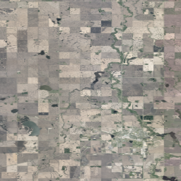
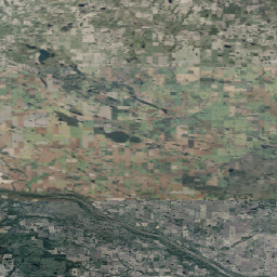
The public orthophotos from the Saskatchewan Geospatial Imagery Collaborative (SGIC).
Available map layers (1)
SGIC_Public_Orthophotos (SGIC_Public_Orthophotos)
The SGIC Orthophotography Project provides seamless, accurate province wide ortho-rectified nadir aerial photography and elevation data of the earth's surface for use in geographic information systems (GIS). The program intends to acquire imagery with a 100 metre buffer beyond the provincial border. The color orthophotos are pre-mosaiced then cut into township tiles before being delivered to the collaborative. Color infrared imagery, RAW images, AT files and a digital elevation model also exist for this area of imagery. The Saskatchewan Geospatial Imagery Collaborative (SGIC) was formed to acquire new aerial photography and satellite imagery of the province. The SGIC is made up of 29 participating organizations including Provincial Government, Crown Corporations, Municipalities, Federal Government, Universities, First Nations, Community Organizations, and Industry. A current list of SGIC members can be found on the imagery access website at www.flysask.ca.
There are currently no notifications for the service, click the feed icon to subscribe.