Northern Ireland Environment Agency |
|
Water Framework Directive Water Bodies (INSPIRE View Service)
http://webservices.spatialni.gov.uk/arcgis/services/NIEA/WFDWaterBodies/MapServer/InspireViewService
| Service health Now: |
|---|
- Interface
- Web Service, OGC Web Map Service 1.3.0
- Keywords
- INSPIRE View, LPS, NI, INSPIRE:ViewService, WMS, INSPIRE, ViewService, infoMapAccessService, ESRI, INSPIRE View, LPS, NI, Water, Lake, Transitional, Coastal, ground water, Hydrography
- Fees
- License
- Access constraints
- license
- Supported languages
- eng
- Data provider
-
Northern Ireland Environment Agency (unverified)
Contact information:
Water Management Unit (WMU)
Northern Ireland Environment Agency
Postal Address:
17 Antrim Road, BT28 3AL Lisburn, Northern IrelandEmail:
Phone: [your telephone number]
- Service metadata
Ads by Google
Water Bodies that had been created to comply with Article 2(7) of the Water Framework Directive were the basis of this dataset. The data was topologically corrected to remove gaps and overlaps from the original digitisation both with the features in the dataset and also with interbasins, river water bodies and transitional waters that were produced for the Water Framework Directive. Begin_Lifespan and End_Lifespan information was added to enable historical data to be kept along with current data in this resource.
Available map layers (5)
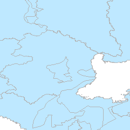
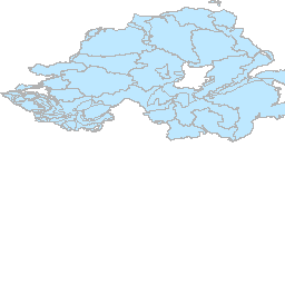
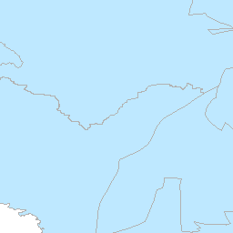
Ground Water Body (Ground_Water_Body)
Layer Ground Water Body
WFD Coastal Water (WFD_Coastal_Water)
Layer WFD Coastal Water
Transitional Water (Transitional_Water)
Layer Transitional Water
Lake Water Body (Lake_Water_Body)
Layer Lake Water Body
River Segment (River_Segment)
Layer River Segment
There are currently no notifications for the service, click the feed icon to subscribe.