U.S. Geological Survey Office of Water… |
|
GeoServer Web Map Service
| Service health Now: |
|---|
- Interface
- Web Service, OGC Web Map Service 1.3.0
- Keywords
- WFS, WMS, GEOSERVER
- Fees
- NONE
- Access constraints
- NONE
- Supported languages
- No INSPIRE Extended Capabilities (including service language support) given. See INSPIRE Technical Guidance - View Services for more information.
- Data provider
-
U.S. Geological Survey Office of Water Information (unverified)
Contact information:
Jessica Lucido
U.S. Geological Survey Office of Water Information
Work:
8505 Research Way, 53562 Middleton, USAEmail:
Phone: 608.821.3841
- Service metadata
- No INSPIRE Extended Capabilities (including service metadata) given. See INSPIRE Technical Guidance - View Services for more information.
Ads by Google
A compliant implementation of WMS plus most of the SLD extension (dynamic styling). Can also generate PDF, SVG, KML, GeoRSS
Available map layers (9)
Latest_WL_Percential (Latest_WL_Percentile)
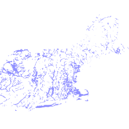
Alluvial and Glacial Aquifers of the United States (NAT_AQFR_ALLUV_GLACL_SPATIAL)
This data set represents the extent of the alluvial and glacial aquifers north of the southern-most line of glaciation. Aquifers are shown in the States of Maine, Vermont, New Hampshire, Connecticut, Massachusetts, Rhode Island, New Jersey, New York, Pennsylvania, Ohio, Indiana, Michigan, Wisconsin, Illinois, Minnesota, Iowa, Missouri, Kansas, Nebraska, South Dakota, North Dakota, and Montana. These data delineate the areal extent of the alluvial and glacial aquifers as defined in The Ground Water Atlas of The United States (GWA).
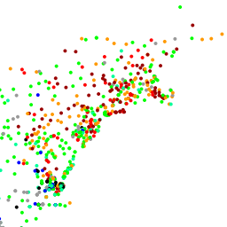
National Ground-Water Monitoring Network Sites (VW_GWDP_GEOSERVER)
Site locations, wells and springs, and metadata for the National Ground-Water Monitoring Network.
VW_IL_CONST (VW_IL_CONST)
VW_IL_LITH (VW_IL_LITH)
VW_IL_QW (VW_IL_QW)
VW_ISWS_WATER_LEVELS (VW_ISWS_WATER_LEVELS)
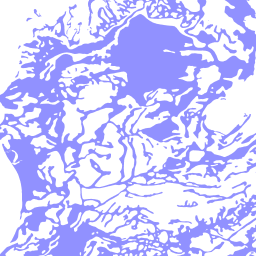
Principal Aquifers of the 48 Conterminous United States, Hawaii, Puerto Rico, and the U.S. Virgin Islands (aquifrp025)
This map layer contains the shallowest principal aquifers of the conterminous United States, Hawaii, Puerto Rico, and the U.S. Virgin Islands, portrayed as polygons. The map layer was developed as part of the effort to produce the maps published at 1:2,500,000 in the printed series "Ground Water Atlas of the United States". The published maps contain base and cultural features not included in these data. This is a replacement for the July 1998 map layer called Principal Aquifers of the 48 Conterminous United States.
central_region_gw_models (central_region_gw_models)
There are currently no notifications for the service, click the feed icon to subscribe.