VĮ GIS-Centras |
|
INSPIRE View Service

| Service health Now: |
|---|
- Interface
- Web Service, OGC Web Map Service 1.3.0
- Keywords
- Hydrography, INSPIRE, WMS, INSPIRE, ViewService, infoMapAccessService
- Fees
- no conditions apply
- Access constraints
- None
- Supported languages
- eng
- Data provider
-
VĮ GIS-Centras (unverified)
Contact information:
VĮ GIS-Centras
VĮ GIS-Centras
postal:
Sėlių g. 66, 08109 Vilnius, LithuaniaEmail:
Phone: 85 2724741
- Service metadata
Ads by Google
This service provides INSPIRE Data.
Available map layers (10)
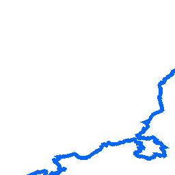
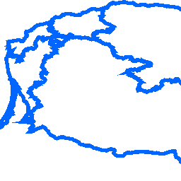
Catchment (HY.PhysicalWaters.Catchments)
Layer Catchment
Catchment - river basin (HY.PhysicalWaters.Catchments.RiverBasin)
Layer Catchment - river basin
Catchment - drainage basin (HY.PhysicalWaters.Catchments.DrainageBasin)
Layer Catchment - drainage basin
Waterbody (HY.PhysicalWaters.Waterbodies)
Layer Waterbody
Waterbody - water course (HY.PhysicalWaters.Waterbodies.Watercourse)
Layer Waterbody - water course
Waterbody - standing water (HY.PhysicalWaters.Waterbodies.StandingWater)
Layer Waterbody - standing water
Man-made Object (HY.PhysicalWaters.ManMadeObject)
Layer Man-made Object
Man-made Object - Sluice (HY.PhysicalWaters.ManMadeObject.Sluice)
Layer Man-made Object - Sluice
Man-made Object - Crossing (HY.PhysicalWaters.ManMadeObject.Crossing)
Layer Man-made Object - Crossing
Man-made Object - Dam or Weir (HY.PhysicalWaters.ManMadeObject.DamOrWeir)
Layer Man-made Object - Dam or Weir
There are currently no notifications for the service, click the feed icon to subscribe.