The James Hutton Institute |
|
1:250,000 Soils and NSIS WMS
http://druid.hutton.ac.uk/arcgis/services/Hutton_NSIS_and_Soils/MapServer/WMSServer

| Service health Now: |
|---|
- Interface
- Web Service, OGC Web Map Service 1.3.0
- Keywords
- Fees
- None
- Access constraints
- James Hutton InstituteLicence
- Supported languages
- No INSPIRE Extended Capabilities (including service language support) given. See INSPIRE Technical Guidance - View Services for more information.
- Data provider
-
The James Hutton Institute (unverified)
Contact information:
David Donnelly
The James Hutton Institute
AB15 8QH Aberdeen, UK
Email:
- Service metadata
- No INSPIRE Extended Capabilities (including service metadata) given. See INSPIRE Technical Guidance - View Services for more information.
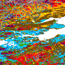
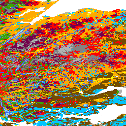
This service includes the National Soil Inventory of Scotland - samples at 10km intervals and the National Soil Map of Scotland. The map data is the digital (vector) version of the Soils of Scotland 1:250,000 maps, which is a generalised soil map, partly derived from a 1:50,000 map of the soils of Scotland. This dataset is an inventory of the soils of Scotland. The soil classification used was updated in 2013 to provide a unified classification across all Soil Survey of Scotland soil maps and profile datasets(UCSS).Version 1.1 of the data includes both the original 1984 and the 2013 soil classification. Version 1.2 of the data included an updated classification table. Version 1.3 of the data include some minor polygon corrections and further revisions to the classification table. Version 1.4 of the data includes some alterations to the symbology used for display. The National Soil Inventory of Scotland (NSIS 1978-88) dataset was collected at sampling points arranged on a 10 km grid across the country. Each sampling point is described and a wide range of soil properties are measured and analysed. These range from contextual information describing the surrounding landscape (such as slope and vegetation), down to detailed chemical analyses of each horizon within the soil profile. There are 721 sites in total.
Available map layers (2)
National soil map of Scotland (0)
The map data is the digital (vector) version of the Soils of Scotland 1:250,000 maps, which is a generalised soil map, partly derived from a 1:50,000 map of the soils of Scotland. This dataset is an inventory of the soils of Scotland. The soil classification used was updated in 2013 to provide a unified classification across all Soil Survey of Scotland soil maps and profile datasets(UCSS).Version 1.1 of the data includes both the original 1984 and the 2013 soil classification. Version 1.2 of the data included an updated classification table. Version 1.3 of the data include some minor polygon corrections and further revisions to the classification table. Version 1.4 of the data includes some alterations to the symbology used for display.
National Soil Inventory of Scotland (1)
The National Soil Inventory of Scotland (NSIS 1978-88) dataset was collected at sampling points arranged on a 10 km grid across the country. Each sampling point is described and a wide range of soil properties are measured and analysed. These range from contextual information describing the surrounding landscape (such as slope and vegetation), down to detailed chemical analyses of each horizon within the soil profile. There are 721 sites in total.