British Geological Survey (BGS) |
|
BGS Bedrock Geology (INSPIRE vocabularies)

| Service health Now: |
|---|
- Interface
- Web Service, OGC Web Map Service 1.3.0
- Keywords
- OneGeology, geology, map, United Kingdom, bedrock, lithology, age, thematic@Bedrock, thematic@Chronostratigraphy, thematic@Lithology, thematic@Harmonised geology, thematic@Harmonised age, MD_LANG@ENG, MD_DATE@2015-10-21, Geology, infoMapAccessService
- Fees
- NONE
- Access constraints
- The 1:625k DiGMap data is made available for all uses - including commercial use, however the British Geological Survey (BGS) at all times retains the copyright in this material and you are not permitted, without an appropriate licence, to set up a service selling on this material. Your own use of any information provided by the British Geological Survey (BGS) is at your own risk. Neither BGS nor the Natural Environment Research Council (NERC) gives any warranty, condition or representation as to the quality, accuracy or completeness of the information or its suitability for any use or purpose. All implied conditions relating to the quality or suitability of the information, and all liabilities arising from the supply of the information (including any liability arising in negligence) are excluded to the fullest extent permitted by law.
- Supported languages
- No INSPIRE Extended Capabilities (including service language support) given. See INSPIRE Technical Guidance - View Services for more information.
- Data provider
-
British Geological Survey (BGS) (unverified)
Contact information:
Mr Garry Baker
British Geological Survey (BGS)
postal:
Environmental Science Centre, NG12 5GG Keyworth, United KingdomEmail:
Phone: +44 (0)115 936 3100
- Service metadata
- No INSPIRE Extended Capabilities (including service metadata) given. See INSPIRE Technical Guidance - View Services for more information.
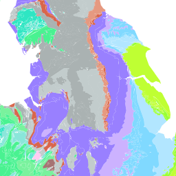
The 1:625k DiGMap data covering the whole of the United Kingdom is available in this OGC WMS service for all uses - including commercial use subject to the conditions in the Access Constraints section. It is being served as a contribution to the OneGeology initiative (www.onegeology.org). Bedrock geology layers are available in this service. Layers available for bedrock are age and lithology. In this service these are attributed and coloured according to INSPIRE standards for age and lithology. For information about more of the British Geological Survey's maps that are available digitally please visit http://www.bgs.ac.uk/products/digitalmaps/digmapgb.html
Available map layers (9)
Geologic Faults (GE.GeologicFault)
MappedFeature (spatial objects) whose specification property is of type ShearDisplacementStructure. This is a group layer which contains the layers falling under the definition that has been created to comply wiht INSPIRE Layer naming conventions.
GBR BGS 1:625k INSPIRE Faults (gsmlp:GBR_BGS_625k_MSF_INSP)
GBR BGS 1:625k scale Bedrock Faults using INSPIRE Faults classification.
Geologic Units (GE.GeologicUnit)
MappedFeature (spatial objects) whose specification property is of type GeologicUnit. This is a group layer which contains the layers falling under the definition that has been created to comply wiht INSPIRE Layer naming conventions.
GBR BGS 1:625k Bedrock INSPIRE Age (gsmlp:GBR_BGS_625k_BA_INSP)
GBR BGS 1:625k scale Bedrock Age using INSPIRE GeochronologicAge classification.
GBR BGS 1:625k Bedrock INSPIRE Lithology (gsmlp:GBR_BGS_625k_BLT_INSP)
GBR BGS 1:625k scale Bedrock Lithology using INSPIRE Lithology classification.
GeologicUnitView (gsmlp:GeologicUnitView)
INSPIRE Schema v3.0 Mapped Feature (ge:MappedFeature)
-- Definition -- A spatial representation of a GeologicFeature. -- Description -- A MappedFeature is part of a geological interpretation. It provides a link between a notional feature (description package) and one spatial representation of it, or part of it (exposures, surface traces and intercepts, etc) which forms the specific bounded occurrence, such as an outcrop or map polygon.
GeoSciML v3.2 Mapped Feature (gsml:MappedFeature)
A MappedFeature is part of a geological interpretation. It provides a link between a notional feature (description package) and one spatial representation of it, or part of it. (Exposures, Surface Traces and Intercepts, etc) * the specific bounded occurrence, such as an outcrop or map polygon * the Mapped Feature carries a geometry or shape - the association with a Geologic Feature (legend item) provides specification of all the other descriptors - the association with a Sampling Feature provides the context and dimensionality A Mapped Feature is always associated with some sampling feature - e.g. a mapping surface, a section, a Borehole (see BoreHolesAndObservation) etc. As noted on the diagram, if the associated sampling feature is a Borehole, then the shape associated with the MappedFeature will usually be either a point or an interval. This reconciles the 2-D ("map", section) and 1-D (borehole, traverse) viewpoints in a common abstraction.
GeoSciML v4.1 Mapped Feature (gsmlb:MappedFeature)
A MappedFeature is part of a geological interpretation. It provides a link between a notional feature (description package) and one spatial representation of it, or part of it. (Exposures, Surface Traces and Intercepts, etc) * the specific bounded occurrence, such as an outcrop or map polygon * the Mapped Feature carries a geometry or shape - the association with a Geologic Feature (legend item) provides specification of all the other descriptors - the association with a Sampling Feature provides the context and dimensionality A Mapped Feature is always associated with some sampling feature - e.g. a mapping surface, a section, a Borehole (see BoreHolesAndObservation) etc. As noted on the diagram, if the associated sampling feature is a Borehole, then the shape associated with the MappedFeature will usually be either a point or an interval. This reconciles the 2-D ("map", section) and 1-D (borehole, traverse) viewpoints in a common abstraction.