Environmental Information Data Centre |
|
LiDAR based Digital Surface Model (DSM) for South West England Web Map Service (WMS)
https://catalogue.ceh.ac.uk/maps/c89cc9a0-dcfa-11e3-8b68-0800200c9a66
| Service health Now: |
|---|
- Interface
- Web Service, OGC Web Map Service 1.3.0
- Keywords
- infoMapAccessService
- Fees
- unknown
- Access constraints
- None
- Supported languages
- eng
- Data provider
-
Environmental Information Data Centre (unverified)
Contact information:
Environmental Information Data Centre
Postal:
UK Centre for Ecology & Hydrology, Lancaster Environment Centre, Library Avenue, Bailrigg, LA1 4AP Lancaster, UKEmail:
- Service metadata
Ads by Google
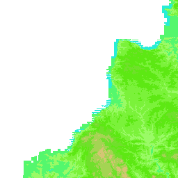
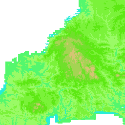
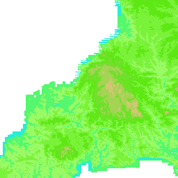
This is a web map service (WMS) of Digital Surface Model (DSM) data in South West England at a 1m resolution. The DSM covers an area of 9424 km2 that includes all the land west of Exmouth (i.e. west of circa 3 degrees 21 minutes West). The DSM includes the height of features on the bare earth such as buildings or vegetation (if present). The dataset is a part of outcomes from the Centre for Ecology & Hydrology South West (SW) Project.
Available map layers (2)
LiDAR based Digital Surface Model (DSM) for South West England Web Map Service (WMS) (WMS)
This is a web map service (WMS) of Digital Surface Model (DSM) data in South West England at a 1m resolution. The DSM covers an area of 9424 km2 that includes all the land west of Exmouth (i.e. west of circa 3 degrees 21 minutes West). The DSM includes the height of features on the bare earth such as buildings or vegetation (if present). The dataset is a part of outcomes from the Centre for Ecology & Hydrology South West (SW) Project.
EL.GridCoverage.SWDSM.1m (EL.GridCoverage.SWDSM.1m)
There are currently no notifications for the service, click the feed icon to subscribe.