Govern d'Andorra |
|
WMS Mapa de refugis i GR d'Andorra
| Service health Now: |
|---|
- Interface
- Web Service, OGC Web Map Service 1.3.0
- Keywords
- WFS, WMS
- Fees
- NONE
- Access constraints
- NONE
- Supported languages
- No INSPIRE Extended Capabilities (including service language support) given. See INSPIRE Technical Guidance - View Services for more information.
- Data provider
-
Govern d'Andorra (unverified)
Contact information:
Àrea de Cartografia
Govern d'Andorra
c/ de la Grau Edifici Prat del Rull Departament d'Ordenament Territorial Àrea de Cartografia, AD500 Andorra la Vella, Andorra
Email:
Phone: 00376875700
- Service metadata
- No INSPIRE Extended Capabilities (including service metadata) given. See INSPIRE Technical Guidance - View Services for more information.
Ads by Google
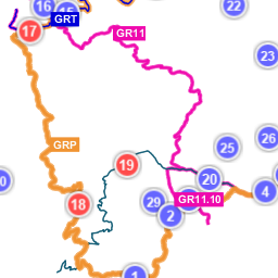
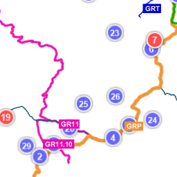
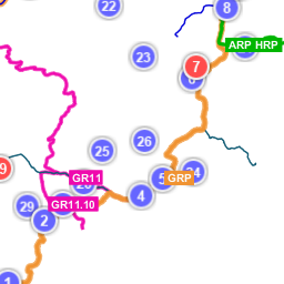
Servei WMS en què es publiquen les dades del mapa de refugis i GR d'Andorra, concretament els recorreguts dels GRT, GR-7, GR-11, GR-11.1, GR11.10, GRP i ARP/HRP, a més dels refugis i altres establiments colaboradors.
Available map layers (11)
Refugis i senders de Gran Recorregut (gr_refugis)
Layer-Group type layer: gr_refugis
GR dels Pirineus : GR-11 (GR11)
GR 11.1 (Variant GR-11) (GR11_1)
GR 11.10 (Variant GR-11) (GR11_10)
GR-7 (GR7)
GR país (GRP)
GR Transfronterer (GRT)
GR_TOTS (GR_TOTS)
Alta Ruta Pirenaica (HRP_ARP)
Refugis (Refugis)
coronallacs (coronallacs)
Recorregut dissenyat en 5 etapes d’entre 13 a 22 km diaris, amb parada per dormir als refugis guardats.
There are currently no notifications for the service, click the feed icon to subscribe.