USGS |
|
GeoServer Web Map Service
| Service health Now: |
|---|
- Interface
- Web Service, OGC Web Map Service 1.3.0
- Keywords
- WFS, WMS, GEOSERVER
- Fees
- NONE
- Access constraints
- NONE
- Supported languages
- No INSPIRE Extended Capabilities (including service language support) given. See INSPIRE Technical Guidance - View Services for more information.
- Data provider
-
USGS (unverified)
Contact information:
USGS Denver Federal Center
USGS
Federal Center, 2nd Street, 80215 Denver, United States
Email:
- Service metadata
- No INSPIRE Extended Capabilities (including service metadata) given. See INSPIRE Technical Guidance - View Services for more information.
Ads by Google
A compliant implementation of WMS plus most of the SLD extension (dynamic styling). Can also generate PDF, SVG, KML, GeoRSS
Available map layers (7)
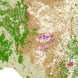
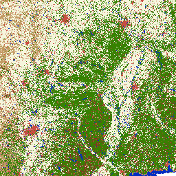
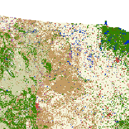
GAP/LANDFIRE National Terrestrial Ecosystems 2011 – USNVC Class (class)
Abstract: This layer represents a crosswalk of the GAP/LANDFIRE National Terrestrial Ecosystems 2011 land cover to the Class level of the U. S. National Vegetation Classification. At the Class level vegetation types are distinguished based on dominant growth form (for example - Forest& Woodland). In addition to the vegetation types in the map legend there are land use classes (for example - open water, agriculture) that are not a part of the USNVC. Visit these sites for more information about the National Classification, the Geographic Data Committee - Vegetation Subcommittee and the USNVC Standard. These data cover the entire continental U.S. and are a continuous data layer. These raster data have a 30 m x 30 m cell resolution.
GAP/LANDFIRE National Terrestrial Ecosystems 2011 – USNVC Division (division)
This layer represents a crosswalk of the GAP/LANDFIRE National Terrestrial Ecosystems 2011 land cover to the Division level of the U. S. National Vegetation Classification. At the Division level vegetation types are distinguished by combinations of growth forms, broad diagnostic plant species, and continental differences in mesoclimate, geology, substrates, hydrology, and disturbance regimes (for example - Vancouverian Cool Temperate Forest & Woodland). In addition to the vegetation types in the map legend there are land use classes (for example - open water, agriculture) that are not a part of the USNVC. Visit these sites for more information about the National Classification, the Geographic Data Committee - Vegetation Subcommittee and the USNVC Standard. These data cover the entire continental U.S. and are a continuous data layer. These raster data have a 30 m x 30 m cell resolution.
GAP/LANDFIRE National Terrestrial Ecosystems 2011 – Ecological System (ecological_system)
This layer represents the finest level of thematic detail for the GAP/LANDFIRE National Terrestrial Ecosystems 2011 land cover. This data layer is the 2011 update of the National Gap Analysis Program Land Cover Data - Version 2.2 for the conterminous U.S. The map legend includes types described by NatureServe's Ecological Systems Classification (Comer et al. 2003) as well as land use classes described in the National Land Cover Dataset 2011 (Homer et al. 2015). These data cover the entire continental U.S. and are a continuous data layer. These raster data have a 30 m x 30 m cell resolution. Comer, P., D. Faber-Langendoen, R. Evans, S. Gawler, C. Josse, G. Kittel, S. Menard, M. Pyne, M. Reid, K. Schulz, K. Snow, and J. Teague. 2003. Ecological Systems of the United States: A Working Classification of U.S. Terrestrial Systems. NatureServe, Arlington, Virginia.
GAP/LANDFIRE National Terrestrial Ecosystems 2011 – USNVC Formation (formation)
This layer represents a crosswalk of the GAP/LANDFIRE National Terrestrial Ecosystems 2011 land cover to the Formation level of the U. S. National Vegetation Classification. At the Formation level vegetation types are distinguished by dominant and diagnostic growth forms and global macroclimate factors as modified by altitude, seasonality of precipitation, substrates and hydrologic conditions (for example - Cool Temperate Forest & Woodland). In addition to the vegetation types in the map legend there are land use classes (for example - open water, agriculture) that are not a part of the USNVC. Visit these sites for more information about the National Classification, the Geographic Data Committee - Vegetation Subcommittee and the USNVC Standard. These data cover the entire continental U.S. and are a continuous data layer. These raster data have a 30 m x 30 m cell resolution.
GAP/LANDFIRE National Terrestrial Ecosystems 2011 – USNVC Group (group)
This layer represents a crosswalk of the GAP/LANDFIRE National Terrestrial Ecosystems 2011 land cover to the Group level of the U. S. National Vegetation Classification. At the Group level vegetation types are distinguished by diagnostic species and growth forms and regional mesoclimate, geology, substrates, hydrology, and disturbance regimes (for example - Cascadian Oregon White Oak - Conifer Forest & Woodland) In addition to the vegetation types in the map legend there are land use classes (for example - open water, agriculture) that are not a part of the USNVC. Visit these sites for more information about the National Classification, the Geographic Data Committee - Vegetation Subcommittee and the USNVC Standard. These data cover the entire continental U.S. and are a continuous data layer. These raster data have a 30 m x 30 m cell resolution.
GAP/LANDFIRE National Terrestrial Ecosystems 2011 – USNVC Macrogroup (macrogroup)
This layer represents a crosswalk of the GAP/LANDFIRE National Terrestrial Ecosystems 2011 land cover to the Macrogroup level of the U. S. National Vegetation Classification. At the Macrogroup level vegetation types are distinguished by diagnostic plant species and growth forms, and sub-continental to regional differences in mesoclimate, geology, substrates, hydrology and disturbance regimes (for example - Southern Vancouverian Dry Foothill Forest & Woodland). In addition to the vegetation types in the map legend there are land use classes (for example - open water, agriculture) that are not a part of the USNVC. Visit these sites for more information about the National Classification, the Geographic Data Committee - Vegetation Subcommittee and the USNVC Standard. These data cover the entire continental U.S. and are a continuous data layer. These raster data have a 30 m x 30 m cell resolution.
GAP/LANDFIRE National Terrestrial Ecosystems 2011 – USNVC Subclass (subclass)
This layer represents a crosswalk of the GAP/LANDFIRE National Terrestrial Ecosystems 2011 land cover to the Subclass level of the U. S. National Vegetation Classification. At the Subclass level vegetation types are based on dominant and diagnostic growth forms and global macroclimatic factors (for example - Temperate & Boreal Forest & Woodland). In addition to the vegetation types in the map legend there are land use classes (for example - open water, agriculture) that are not a part of the USNVC. Visit these sites for more information about the National Classification, the Geographic Data Committee - Vegetation Subcommittee and the USNVC Standard. These data cover the entire continental U.S. and are a continuous data layer. These raster data have a 30 m x 30 m cell resolution.
There are currently no notifications for the service, click the feed icon to subscribe.