Agriculture and Agri-Food Canada / Agr… |
|
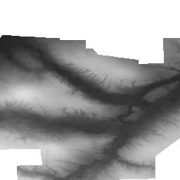
Swift Current LiDAR Project 2009 - DEM / Projet LiDAR de Swift Current 2009 - MAN


| Service health Now: |
|---|
- Interface
- Web Service, OGC Web Map Service 1.3.0
- Keywords
- Drainage, Remote sensing, Aerial photography, Floods, lang-en, Drainage, Télédétection, Photographie aérienne, Inondation, lang-fr
- Fees
- unknown
- Access constraints
- © Government of Canada (2018). Data are subject to the Government of Canada Open Data Licence Agreement: http://open.canada.ca/en/open-government-licence-canada. The terms of this Agreement govern your use and reproduction of the data instead of the copyright reproduction statements found in Important Notices on the Agriculture and Agri-Food Canada website. / © Gouvernement du Canada (2018). L'utilisation des données est assujettie à l'Accord de licence de données libres du gouvernement du Canada, disponible à : http://ouvert.canada.ca/fr/licence-du-gouvernement-ouvert-canada. Les modalités de l'accord régissent l'utilisation et la reproduction des données plutôt que les énoncés des droits d'auteur et de reproduction figurant dans les Avis importants sur le site Web d'Agriculture et Agroalimentaire Canada.
- Supported languages
- No INSPIRE Extended Capabilities (including service language support) given. See INSPIRE Technical Guidance - View Services for more information.
- Data provider
-
Agriculture and Agri-Food Canada / Agriculture et Agroalimentaire Canada (unverified)
Contact information:
Agri-Geomatics / Agrogéomatique
Agriculture and Agri-Food Canada / Agriculture et Agroalimentaire Canada
Canada
Email:
- Service metadata
- No INSPIRE Extended Capabilities (including service metadata) given. See INSPIRE Technical Guidance - View Services for more information.
Ads by Google
Digital Elevation Model (DEM) created from LiDAR data captured by McElhanney Consulting Services Ltd (MCSL). The DEM represents the elevation of the landscape covered by this project. For more information, visit: http://open.canada.ca/data/en/dataset/72003a79-c799-49de-b135-de5af833f029 / Modèle altimétrique numérique (MAN) créée à partir de données LiDAR capturés par McElhanney Consulting Services Ltd (MCSL). Le MAN représente l'élévation du paysage visé par le présent projet. Pour plus d'information, consulter : http://ouvert.canada.ca/data/fr/dataset/72003a79-c799-49de-b135-de5af833f029
Available map layers (1)
aafc_sk_swift_current_2009_1m_dem (0)
Digital Elevation Model (DEM) created from LiDAR data captured by McElhanney Consulting Services Ltd (MCSL). The DEM represents the elevation of the landscape covered by this project. For more information, visit: http://open.canada.ca/data/en/dataset/72003a79-c799-49de-b135-de5af833f029 / Modèle altimétrique numérique (MAN) créée à partir de données LiDAR capturés par McElhanney Consulting Services Ltd (MCSL). Le MAN représente l'élévation du paysage visé par le présent projet. Pour plus d'information, consulter : http://ouvert.canada.ca/data/fr/dataset/72003a79-c799-49de-b135-de5af833f029
There are currently no notifications for the service, click the feed icon to subscribe.